

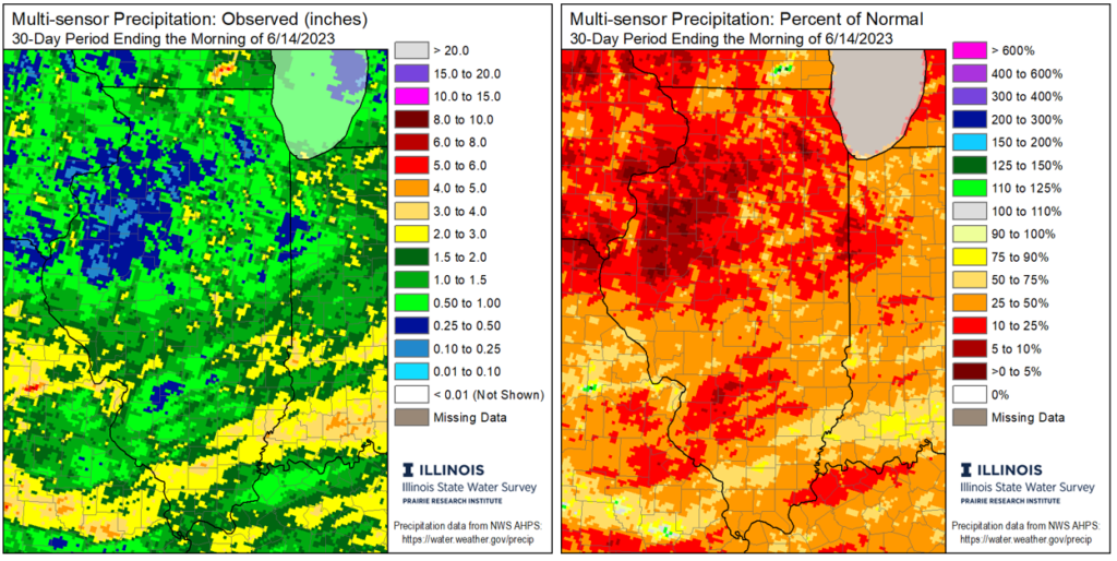
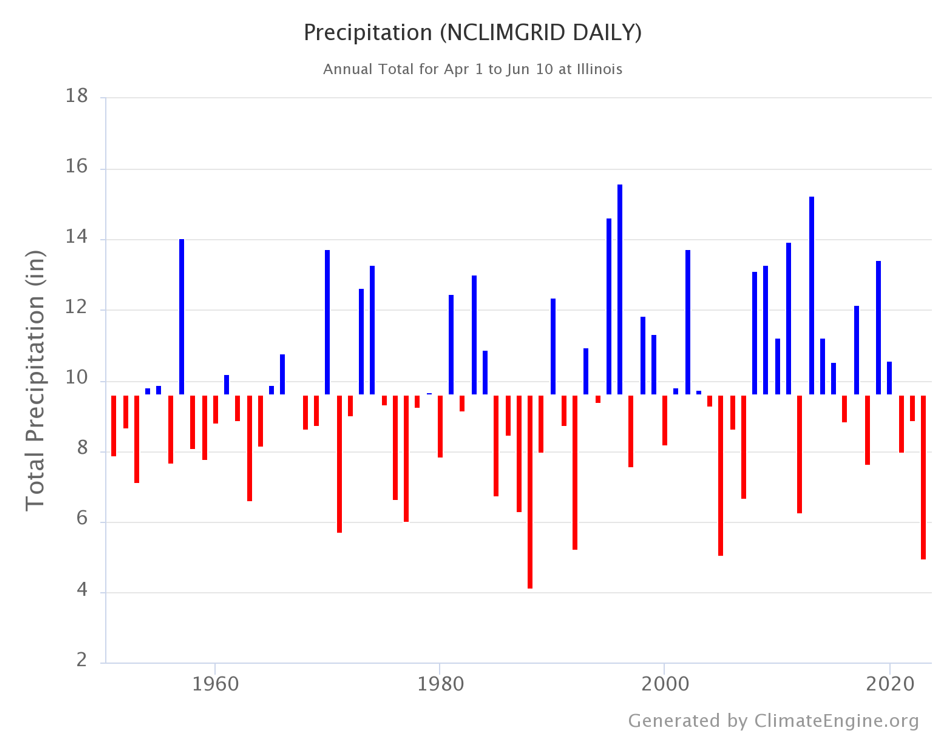
Dry conditions have persisted through May and into the first two weeks of June. While some parts of Illinois have received beneficial rain in the past week, totals have mainly been less than 1 inch, not enough to improve conditions. The maps in Figure 1 show most of Illinois has had less than 2 inches of rain over the past 30 days. The northern half of the state has largely seen less than 50 percent of normal rainfall since April 1st, and parts of the Chicagoland area have had less than 25 percent over that period. In fact, the period between April 1st and June 10th was the second driest on record statewide, wetter only than 1988.
A wetter winter and lack of extreme heat so far this summer have both helped limit drought impacts so far. Reports across the state indicate lawns are browning or going dormant, gardens, shrubs, and small trees require frequent watering, and mature trees are beginning to show stress. Streamflow in much of the state is well below normal and is near the record low at a few places on the Illinois River, including Henry and Valley City. Crop reports indicate corn and soybeans in parts of southwestern, central, and northeastern Illinois are showing some stress, including rolling corn leaves and slowed growth. However, the overall feeling is that yield potential has not been significantly affected at this point. Pasture conditions have declined to a larger extent than row crops, and there are some concerns about hay yield and quality moving forward.
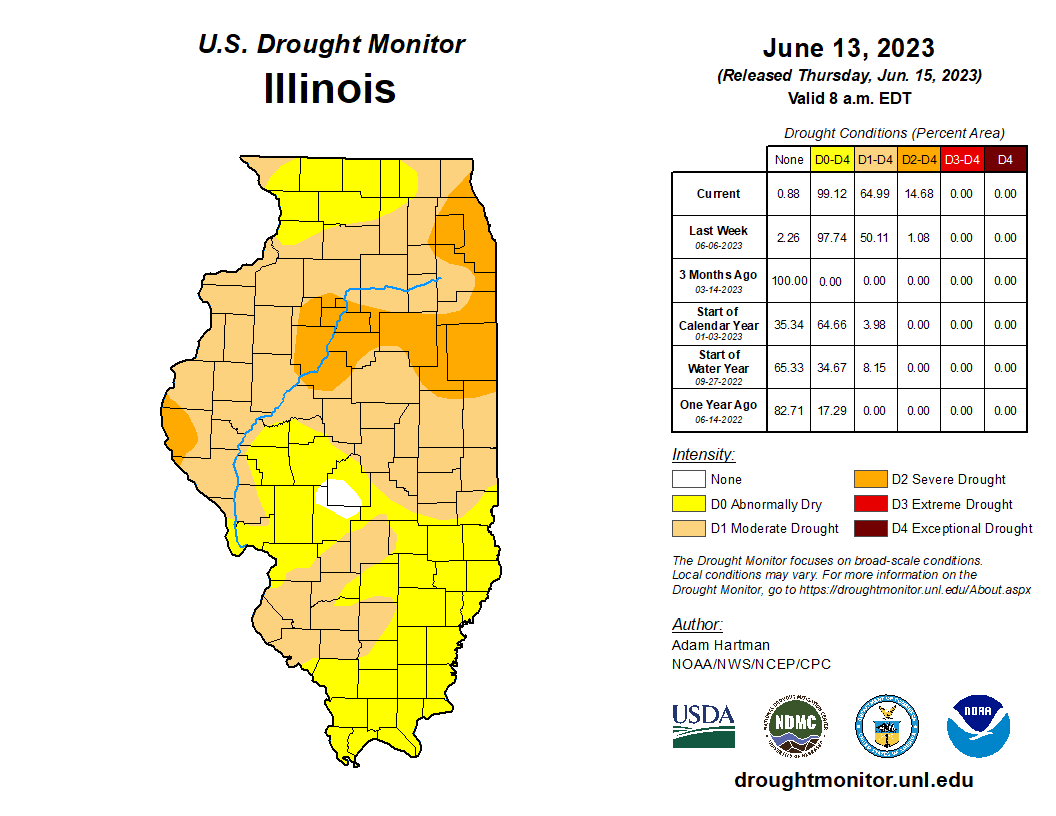
The US Drought Monitor on June 13th shows severe drought (D2) in northeastern and central Illinois, including most of the Chicagoland area and all of Peoria (Figure 2). Most of the state north of Interstate 70 is in abnormal drought, as is much of the St. Louis Metro east area, while southern Illinois remains abnormally dry.
Outlooks
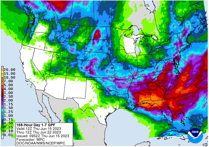
The most recent 7-day precipitation forecast from the National Weather Service shows more rain for the southern half of the state, with widespread chances of 1 to 1.5 inches in the next week (Figure 3). However, less accumulation is forecast for central and northern Illinois, with totals mostly less than half an inch. While some rain is better than no rain, we will need more consistent wetter conditions soon to avoid worsening impacts. To be clear, if we continue in a somewhat to very dry pattern over the next three to four weeks, we will likely see more extensive and severe drought impacts.
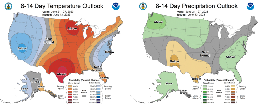
Farther out, the outlooks for the latter half of June show the highest chances of near normal rainfall and above normal temperatures (Figure 4). Warmer weather could quicken impacts through higher evaporation, but even near normal precipitation in late June would help reduce impacts as we move into the heart of the growing season.
What Can I do?
The message is the same as it was in the early stage of drought: water conservation and condition reports. Water conservation is extremely important to minimize the decline of stream and lake levels. Additionally, citizen reports of drought conditions and impacts greatly assist with the drought management effort. Reports can include how wet or dry it is around you, impacts to trees, gardens, pastures, crops, etc., and stream or pond levels around you.
Impact reports can be submitted through:
The National Drought Mitigation Center’s Condition Monitoring Observer Reporting (CMOR) system: go.illinois.edu/cmor.
or via email to the Illinois State Climatologist Office: statecli@isws.illinois.edu.
Also, if you observe precipitation for CoCoRaHS, please consider submitting a weekly condition monitoring report: https://www.cocorahs.org/content.aspx?page=condition. Every report makes a difference and helps us understand drought conditions and can direct help and resources where they need to go in the state.
Partners
National Weather Service Offices
Chicago: https://www.weather.gov/lot/drought
Quad Cities: https://www.weather.gov/dvn/drought
Central IL: https://www.weather.gov/ilx/drought
St. Louis: https://www.weather.gov/lsx/drought
Southern IL: https://www.weather.gov/pah/drought
National Drought Mitigation Center: drought.unl.edu
National Integrated Drought Information System (NIDIS): drought.gov/drought/