
Chicago lies midway between the Continental Divide and the Atlantic Ocean, and is 900 miles north of the Gulf of Mexico. Chicago’s climate is typically continental with cold winters, warm summers, and frequent short fluctuations in temperature, humidity, cloudiness, and wind direction. Many consider the more moderate temperatures of spring and fall to be the most pleasant. Lake Michigan provides a moderating influence on temperature while boosting the amount of snowfall received in the city.
Climatic controls
Four factors control the continental climate of Chicago: 1) the sun, 2) weather systems, 3) urban areas, and 4) Lake Michigan. Two major controls are latitude (reflecting the amount of solar input) and weather systems (air masses and cyclonic storms). The effects of Lake Michigan and the urban area are of lesser significance but they influence local climate conditions to varying degrees within the Chicago metropolitan area, rather than uniformly across the entire region.
The sun, primary energy source for virtually all weather phenomena, in large part determines air temperatures and seasonal variations. Solar energy is three to four times greater in early summer than in early winter at Chicago’s mid-latitude location; which results in warm summers and cold winters.
Weather systems, the second major factor affecting the city’s climate, create the wide variety of weather conditions that occur almost daily as a result of varying air masses and passing storm systems. The polar jet stream often is located near or over Illinois, especially in fall, winter, and spring, and is the focal point for the creation and movement of low-pressure storm systems characterized by clouds, winds, and precipitation. The settled weather associated with high-pressure systems is generally ended every few days by the passage of low-pressure systems.
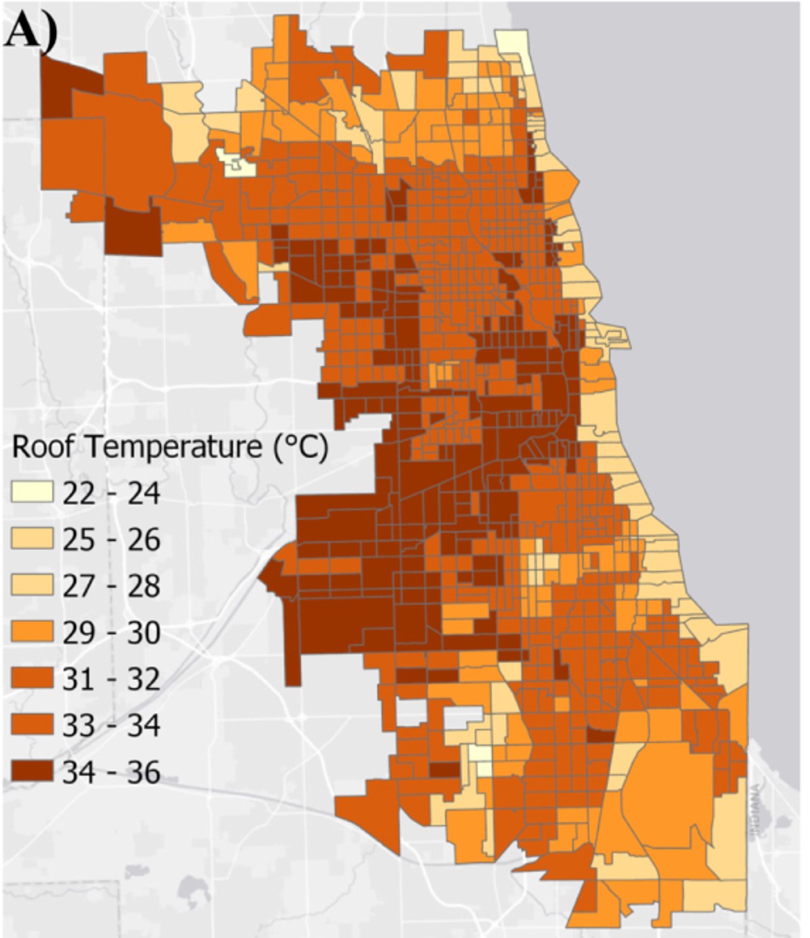
The first local feature is the urban climate in the Chicago metropolitan area. Buildings, parking lots, roads, and industrial activities make the urban climate noticeably different than that of surrounding rural areas. For example, Chicago tends to be warmer by 2°F, on average, especially at night. In some cases, this difference can be higher. This particle feature of the urban climate is usually called the “urban heat island effect.” Because of differences in development, land use, and greenspace (i.e., parks, trees, etc.), the urban heat island effect is more intense in some neighborhoods than others. The map below shows differences in roof top temperature by census tract across the city, showing the hotter parts of Chicago, relative to others.
Urban areas also cause changes in humidity, cloudiness, wind speeds and directions. Not only do the built up areas cause warmer temperatures but they also increase the runoff of rainwater, leading to increased flooding.
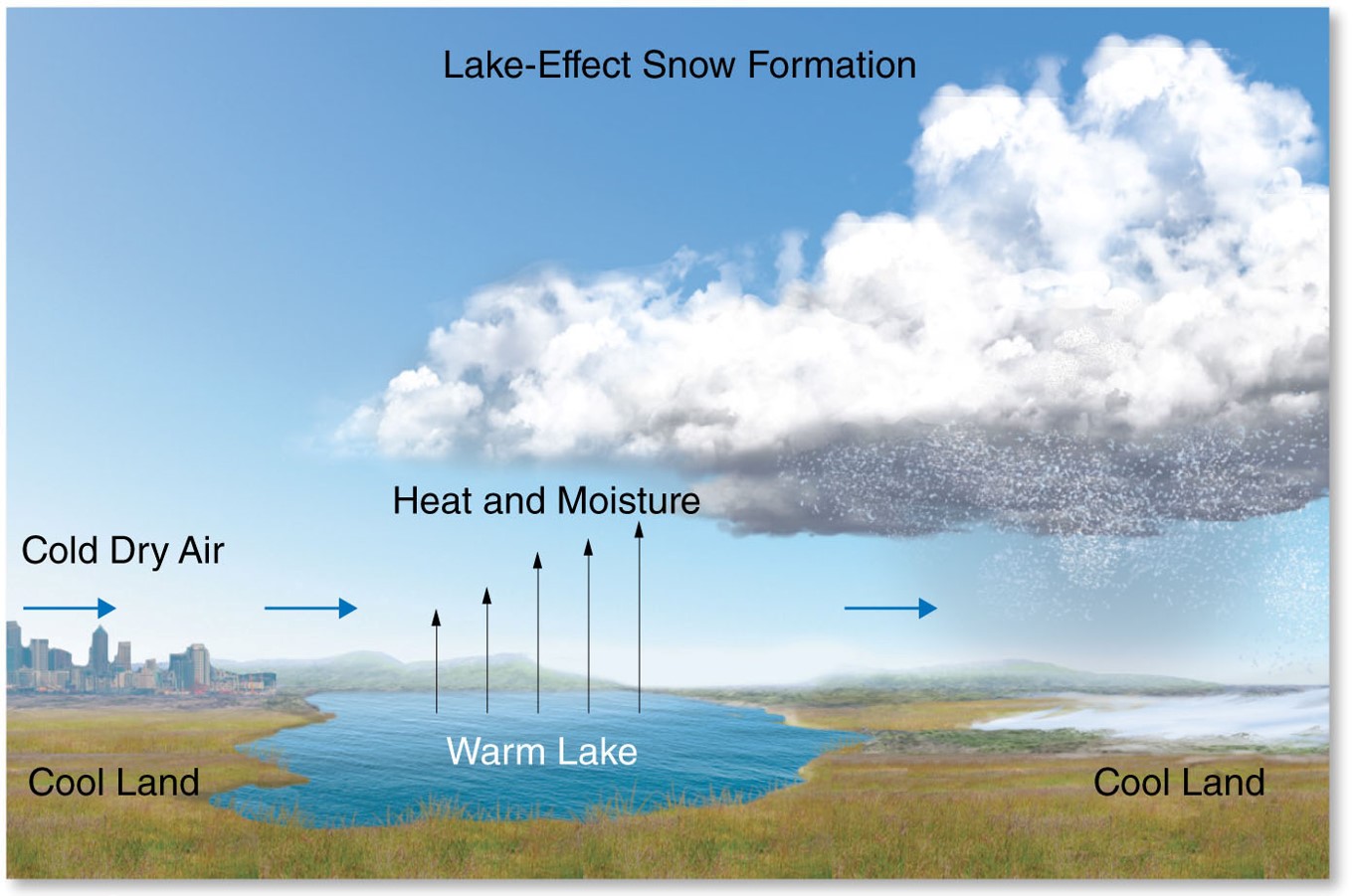
Lake Michigan influences the climate of Chicago and most of northeastern Illinois. The large thermal mass of the lake tends to moderate temperatures, causing cooler summers and warmer winters. One of the major benefits is cool lake breezes that provide some relief from summer heat. The lake also tends to increase cloudiness in the area and suppress summer precipitation. Winter precipitation is enhanced by lake-effect snows that occur when winds blow from the north or northeast. These winds allow air to pass over the relatively warm lake, boosting storm system energy and water content, and leading to increased snowfall (see figure below). However, because the predominant wind in the cold season blows out of the west or northwest, Chicago does not experience as much lake-effect snow as areas on the downwind lake coast, like western Michigan.
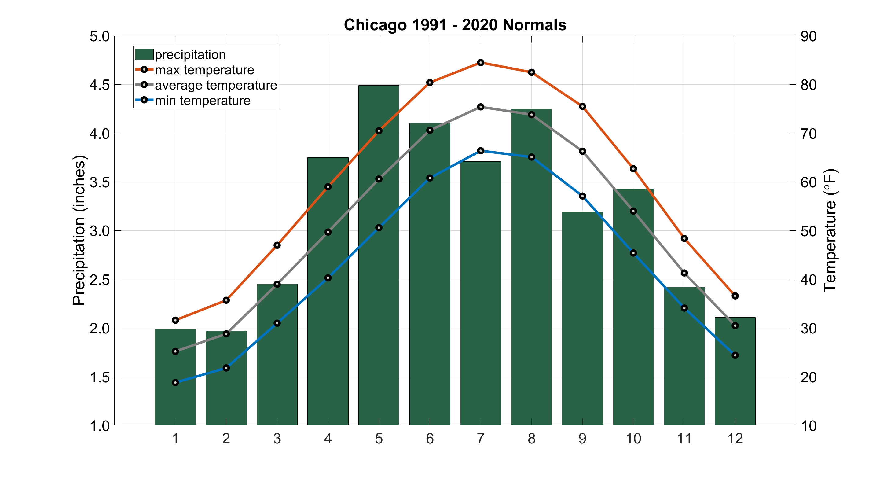
Climate normals for O’Hare Airport is featured here and based on data from NCDC. More climate and weather data can be found at the National Weather Service (NWS) office for Chicago.
Monthly and Annual Normals (from O’Hare Airport)
| MONTH/ANNUAL | HIGH (F) | LOW (F) | MEAN (F) | # DAYS HIGH ≥ 90 | # DAYS LOW ≤ 0 |
|---|---|---|---|---|---|
| January | 31.6 | 18.8 | 25.2 | 0.0 | 3.5 |
| February | 35.7 | 21.8 | 28.8 | 0.0 | 1.8 |
| March | 47.0 | 31.0 | 39.0 | 0.0 | 0.2 |
| April | 59.0 | 40.3 | 49.7 | 0.0 | 0.0 |
| May | 70.5 | 50.6 | 60.6 | 0.8 | 0.0 |
| June | 80.4 | 60.8 | 70.6 | 4.1 | 0.0 |
| July | 84.5 | 66.4 | 75.4 | 6.5 | 0.0 |
| August | 82.5 | 65.1 | 73.8 | 3.7 | 0.0 |
| September | 75.5 | 57.1 | 66.3 | 1.6 | 0.0 |
| October | 62.7 | 45.4 | 54.0 | 0.0 | 0.0 |
| November | 48.4 | 34.1 | 41.3 | 0.0 | 0.0 |
| December | 36.6 | 24.4 | 30.5 | 0.0 | 1.1 |
| Annual | 59.5 | 43.0 | 51.2 | 16.7 | 6.5 |
| MONTH/ANNUAL | PRECIPITATION (IN.) | SNOW (IN.) | WIND DIR (DEGREES) | WIND SPD (MPH) | RELATIVE HUMIDITY (%) |
|---|---|---|---|---|---|
| January | 1.99 | 11.3 | 280 | 11.3 | 75 |
| February | 1.97 | 10.7 | 300 | 11.1 | 74 |
| March | 2.45 | 5.5 | 280 | 11.4 | 70 |
| April | 3.75 | 1.3 | 30 | 11.3 | 66 |
| May | 4.49 | 0.0 | 40 | 10.1 | 66 |
| June | 4.10 | 0.0 | 220 | 8.8 | 67 |
| July | 3.71 | 0.0 | 240 | 8.4 | 69 |
| August | 4.25 | 0.0 | 240 | 8.0 | 72 |
| September | 3.19 | 0.0 | 190 | 8.5 | 71 |
| October | 3.43 | 0.2 | 220 | 9.8 | 70 |
| November | 2.42 | 1.8 | 220 | 10.8 | 73 |
| December | 2.11 | 7.6 | 270 | 10.5 | 76 |
| Annual | 37.86 | 38.4 | 280 | 10.0 | 71 |
| MONTH/ANNUAL | HEATING DEGREE DAYS | COOLING DEGREE DAYS | DAYS W/ HVY FOG | DAYS W/ THUNDER | CLOUDY DAYS |
|---|---|---|---|---|---|
| January | 1234 | 0 | 1.8 | 0.4 | 18.0 |
| February | 1015 | 0 | 1.5 | 0.5 | 15.7 |
| March | 808 | 2 | 2.0 | 2.2 | 17.6 |
| April | 468 | 8 | 0.7 | 3.9 | 16.4 |
| May | 198 | 60 | 1.0 | 5.2 | 13.9 |
| June | 31 | 199 | 0.5 | 6.3 | 11.2 |
| July | 2 | 326 | 0.3 | 5.9 | 10.1 |
| August | 4 | 277 | 0.5 | 6.1 | 10.4 |
| September | 77 | 116 | 0.4 | 4.1 | 11.2 |
| October | 355 | 15 | 0.7 | 1.7 | 13.3 |
| November | 713 | 0 | 1.0 | 1.0 | 17.7 |
| December | 1069 | 0 | 1.8 | 0.5 | 18.5 |
| Annual | 5974 | 1003 | 12.2 | 37.8 | 174.0 |
Here is what they said about the climate of Chicago in 1913:
“The city is located in latitude 41 35′ North, somewhat less than half-way from the equator to the pole, on a crescent-shaped plain about 581 feet above mean sea level. This plain at its highest point is considerably less than 100 feet above the surface of the lake, and its greatest width is approximately 15 miles in a northeast-southwest direction. The whole plain is bordered inland by a glacial moraine which rises in places to about 150 feet above the higher portions of the plain itself. This rim is far too low to exert any appreciable effect upon the climatic or weather conditions of the city, and forms no barrier to either cold-wave areas from the west or hot winds from the southwest and south. Such barrier, however, is but infrequently needed, as many times the waters of the lake serve to soften the rigors of the wintry storms or moderate the intensity of the summer’s heat.
Located as it is at the southwest corner of the lake, Chicago is justly proud of its climate. As a consequence of the cool expanse of water in summer, the city often enjoys delightful and refreshing breezes while the interior of the country away from the lake is sweltering in an air hot and still almost to the point of suffocation. The city is close to certain well-defined storm tracks, and the passage of these disturbances insures ample precipitation and interrupts the otherwise monotonous cycles of temperature and weather change. Chicago has been called the “Windy City” and the ensuing pages will show that there is some reason for the sobriquet, although the wind movement here is not much greater than it is at other places in the Great Lakes region. Its changes in weather are often sudden and pronounced, but usually are of such character as to have a stimulating effect upon the average person of health; and it is not at all improbable that the great energy of its people, which has resulted in the rapid upbuilding of Chicago, is due largely to the peculiar nature of its climate.”
Excerpt from The Weather and Climate of Chicago, The Geographic Society of Chicago, Bulletin No. 4, H.J. Cox and J.H. Armington, University of Chicago Press, 1913.
Note: Google Books has the 1913 “The Weather and Climate of Chicago” by Cox and Armington and the more rare 1893 “The Climate of Chicago” by Hazen.