The preliminary statewide average March temperature was 45.8 degrees, 4.4 degrees above the 1991–2020 average and the 14th warmest on record going back to 1895. The preliminary statewide average total March precipitation was 3.09 inches, 0.15 inches above the 1991–2020 average and the 60th wettest on record statewide.
Data are provisional and may change slightly over time
Mild Start and Bumpy End to March
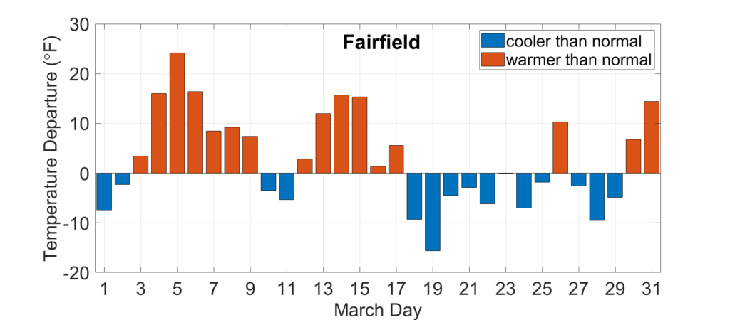
Mild temperatures from February carried over to the first half of March in Illinois. Most of the first 15 days of March were warmer than normal in the state, including in Fairfield (Figure 1). A strong storm system pulled in very warm and humid air from the Gulf of Mexico on March 5, sending high temperatures into the 70s and 80s across the state. However, the second half of the month had more days with below normal temperatures and multiple rounds of sub-freezing nighttime low temperatures.
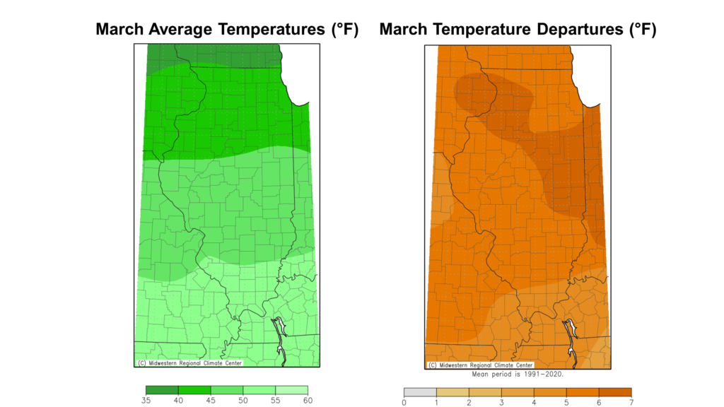
March average temperatures ranged from the low 40s in northern Illinois to the low 50s in southern Illinois, between 2 and 5 degrees above normal (Figure 2). The warmest place in the state last month was Du Quoin at 53.4 degrees on average, and the coldest place in the state last month was Stockton at 39.6 degrees. It was the 5th warmest March on record in Peoria, the 6th warmest in Freeport, and the 9th warmest in both Moline and Rockford.
The mild weather in the first half of the month broke 77 daily high maximum temperature records and 32 daily high minimum temperature records in Illinois. The colder weather that settled in the back half of March broke three daily low minimum temperature records, including 21 degrees in Kaskaskia.
Overall, the preliminary statewide average March temperature was 45.8 degrees, 4.4 degrees above the 1991–2020 average and the 14th warmest on record going back to 1895.
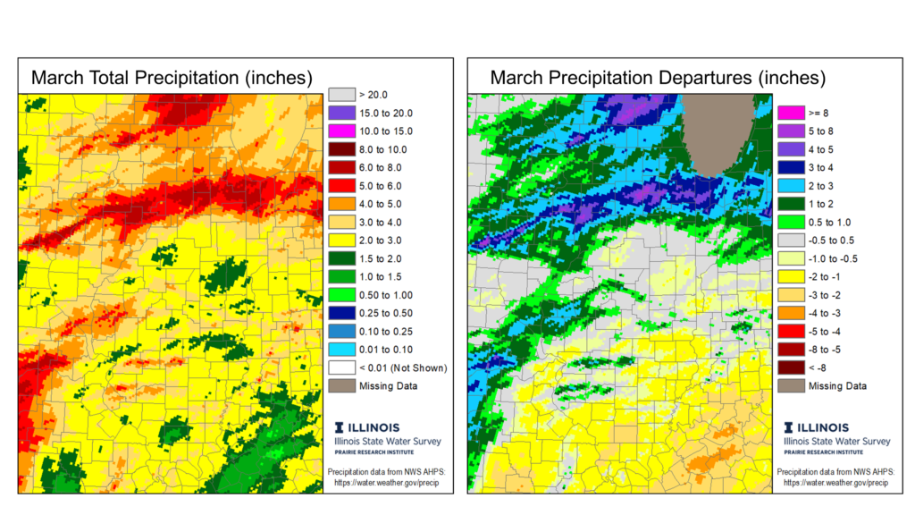
Mixed Wet and Dry Conditions in March
The first two months of the year included a top 15 wettest January on record and the 2nd driest February on record in Illinois. March gave us a little taste of both worlds, with wetter conditions in the north and drier conditions in the south. March total precipitation ranged from over 6 inches in north-central Illinois to less than 2 inches in southern Illinois. Most of the state north of Interstate 70 had a near-normal to wetter than normal March, while much of southern Illinois was 1 to 3 inches drier than normal (Figure 3).
Overall, the preliminary statewide average total March precipitation was 3.09 inches, 0.15 inches above the 1991–2020 average and the 60th wettest on record statewide.
Uh Oh, March Hail and Snow
Unfortunately, not all March precipitation was rain. While March wasn’t nearly as active for severe weather as last year, we did get quite a bit of hail across Illinois. The Storm Prediction Center’s preliminary count had 68 severe hail reports across Illinois last month, including eight reports of 2-inch (i.e., hen egg size) or larger diameter hail. If you feel like Illinois has had a lot of hail in the month of March recently, you’re not wrong. Each of the last two years have had more than 45 severe hail reports across the state, following a stretch of five years between 2018 and 2022 with only 37 severe hail reports total.
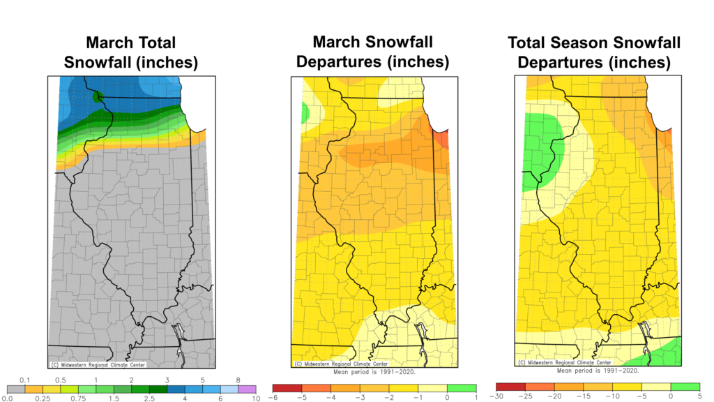
Meanwhile, as it often does, March brought some snowfall to northern Illinois. Most places north of Interstate 80 saw some accumulation in March, with some isolated 8- to 9-inch totals in Boone and McHenry Counties. Despite the impressive totals, March still ended with below normal snowfall for the entire state, adding to deficits from the rest of the snow season (Figure 4).
April & Late Spring Outlooks
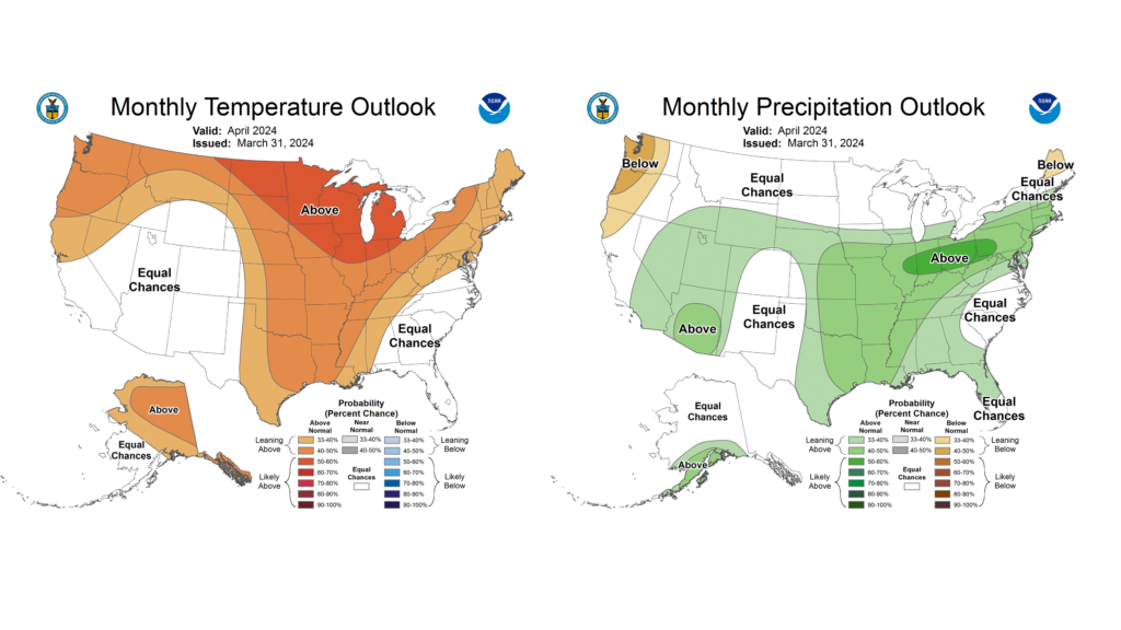
April is an important weather month in Illinois because it ushers in a typically wet three-month period that also brings the highest threat of severe weather. April is also when we see spring fieldwork and planting in earnest across the state. And this year, April is particularly interesting because of the solar eclipse on the 8th. I’ll refer to the National Weather Service for an official eclipse forecast, and instead present the outlooks for April and the three-month period between April and June.
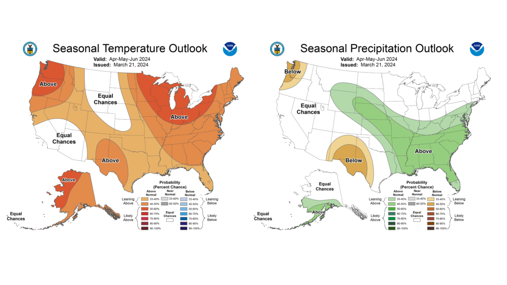
The final April outlook from the Climate Prediction Center has highest chances of warmer and wetter than normal conditions in this important month (Figure 5). The April-June period also leans warmer and wetter than normal in Illinois (Figure 6).