

Thunderstorms develop in warm, moist air in advance of eastward- moving cold fronts. These thunderstorms often produce hail, strong winds, and tornadoes. A tornado is a violent rotating column of air extending from a thunderstorm to the ground. The damage from a tornado is a result of the high wind speeds and wind-blown debris.
Tornadoes can and do occur at any time of the year, although peak tornado frequency in Illinois is between April and June. Tornadoes tend to occur in the afternoons and evenings with 50% occurring between 3 p.m. and 7 p.m. Illinois averaged 54 tornadoes per year based on the 1991-2020 data.
How do tornadoes form?
Before thunderstorms develop, a change in wind direction and an increase in wind speed with increasing height creates an invisible, horizontal spinning effect in the lower atmosphere. Rising air within the thunderstorm updraft tilts the rotating air from horizontal to vertical. An area of rotation, 2 to 6 miles wide, now extends through much of the storm. Most strong and violent tornadoes form within this area of strong rotation. The newer National Weather Service Doppler radar can detect these areas of rotation, leading to an earlier warning time.
Tornado Facts
- Tornadoes can be almost invisible, marked only by swirling debris at the base of the funnel. Some are composed of several mini-funnels.
- On average, the United States experiences 100,000 thunderstorms per year. About 1,000 tornadoes develop from these storms.
- The prime tornado period in Illinois is April through June, with 63% of Illinois’ tornadoes occurring during that time.
- Average number of tornadoes in Illinois is 54 per year, but there were none in 1919 and 1933, and as many as 124 tornadoes in 2006.
- There are no real time trends in the number of tornadoes. However, a sharp increase after 1954 is due to greater attention to tornadoes by the National Weather Service with better data collection and studies. A second increase appears to have occurred in the mid-1990s as the new NWS Doppler radar systems became operational in Illinois.
- Illinois has experienced two of the worst tornadoes in the nation’s history: the infamous Tri-State tornado of March 18, 1925, which resulted in 695 deaths, 2000 injuries, and $130 million in property damage; and the Mattoon tornado of May 26, 1917, which resulted in 101 deaths, 638 injuries, and $55 million in property damage.
- Damage to buildings is caused by violent winds and debris slamming into the building, not by the low pressure of the tornado as it passes overhead.
Tornado Data & Accounts for Illinois
Recent Tornado Data
| Year | |||
|---|---|---|---|
Searchable tornado data from other past years is available through the NOAA National Centers for Environmental Information.
Some Noteworthy Illinois Tornado Events
- The record-setting 2006 tornado season
- National Weather Service account of the March 18, 1925 Tri-State Tornado
- National Weather Service account of the May 26, 1917, Mattoon Tornado
- National Weather Service list of significant Chicago-area tornadoes.
Tornado Seasonality
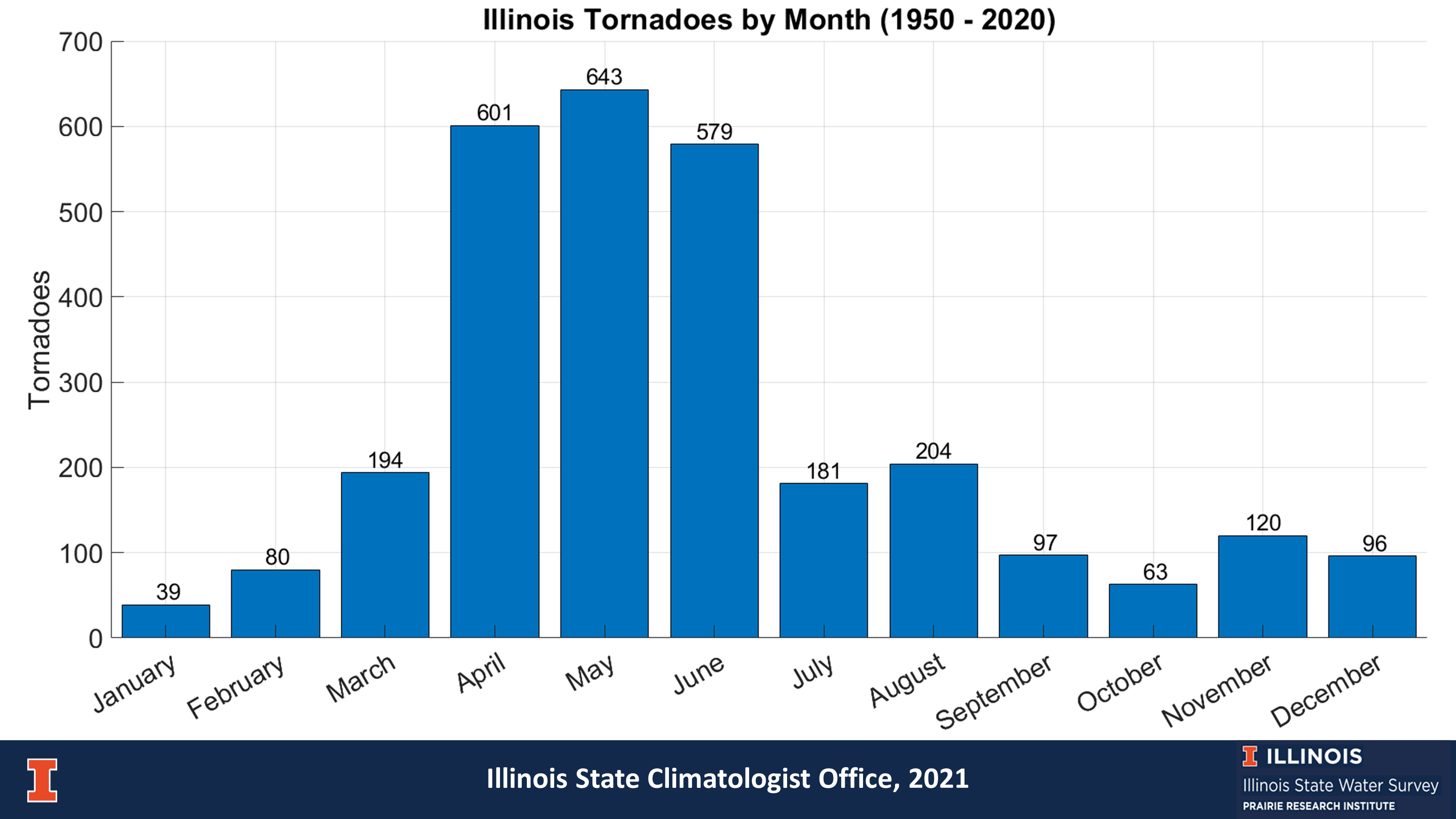
The plot above shows the frequency of tornadoes in Illinois by month between 1950 and 2020. About 64 percent of tornadoes over that time occurred between April and June; however, tornadoes do occur outside of this time. For example, between 1950 and 2020 more tornadoes occurred in December and February together than in September and October together.
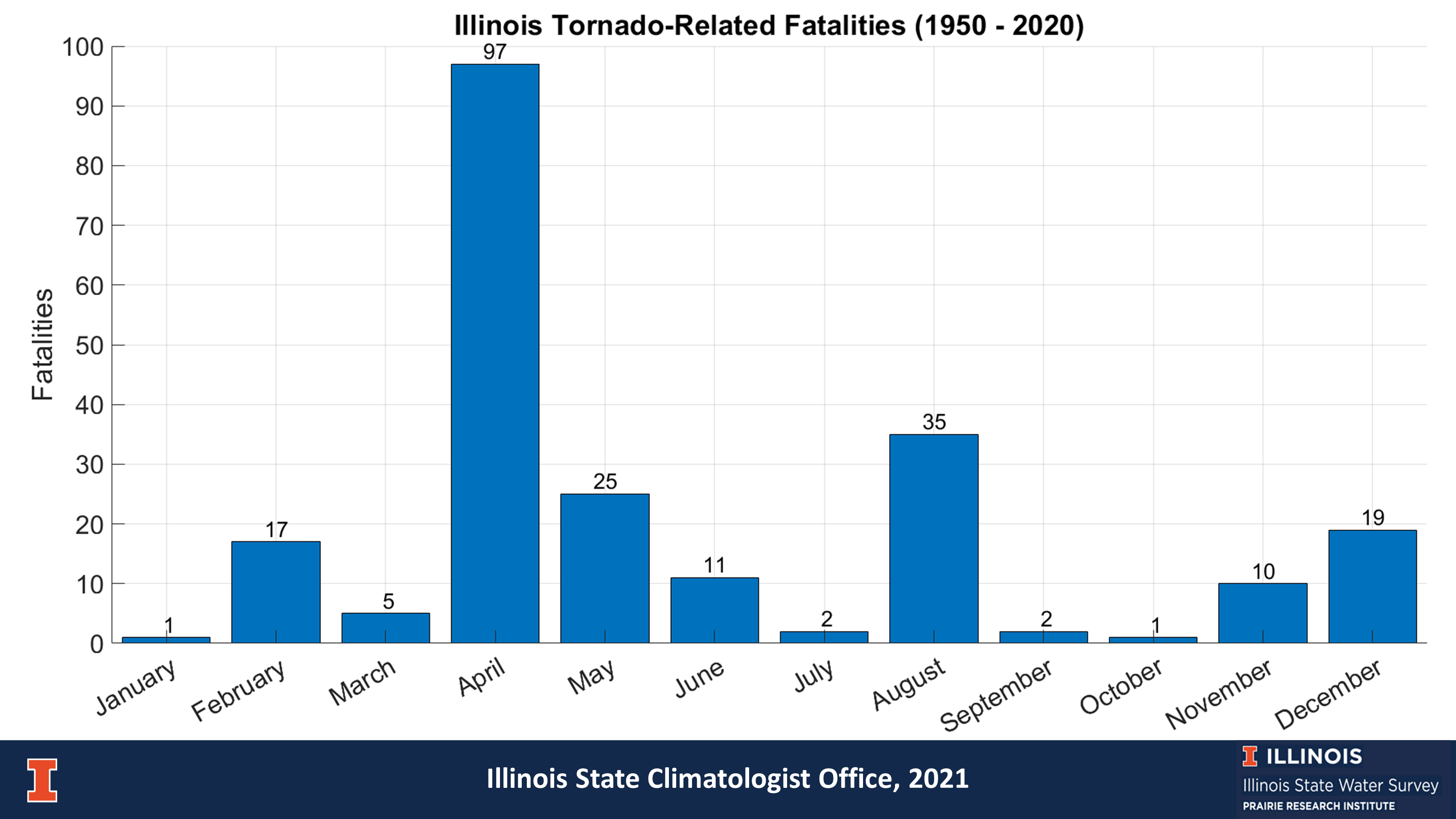
This plot shows the number of tornado-related fatalities by month for Illinois. April is the deadliest month with 97 reported deaths, mostly due to the 58 deaths associated with the 1967 Oak Lawn tornado outbreak. The second deadliest month was August, mostly due to the 29 deaths associated with the August 28, 1990, Plainfield event.
Importantly, December and February are the 4th and 5th deadliest months in Illinois despite have the 4th and 5th fewest tornadoes, respectively.
Tornado Plots for Illinois
Using tornado statistics provided by the National Climatic Data Center, here we explore the relationship of selected tornado characteristics with hour of the day, month of the year, from year to year, etc. This was part of a Capstone project by Michael Patrick, a senior (2011) in the Department of Atmospheric Science at the University of Illinois. Nearly all the plots have been updated through 2020. Click any plot to enlarge.
First Radar-Detected Tornado
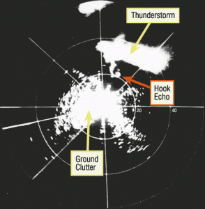
The first documented case of a tornado being detected by radar occurred near Champaign, Illinois. On April 9, 1953, while running tests on a research radar unit after hours, Don Staggs of the Illinois State Water Survey discovered an interesting radar return and began recording it using a 35mm camera. As a result, he was able to document the development, growth, and movement of a tornado, as identified by the distinctive “hook echo.” This was later correlated with damage reports from the area. This discovery helped in push for a nationwide network of radar sites in the 1950s to spot and track tornadoes.
Tornado Maps for Illinois (1950 – 2010)
Tornadoes frequently occur in Illinois with numbers that are comparable to those in “tornado alley” in the Great Plains. Here are maps showing the geographic distribution of tornadoes across Illinois, each county, and the Midwest for 1950-2010. The data were obtained from NOAA’s Storm Prediction Center and mapped using ArcGIS.