
Parts of northeast, western, and central Illinois have been much drier than normal in the past 4 to 6 weeks, causing dry soils and lower streamflow. Perennials, gardens, and young trees in these areas have begun to show some response to the dryness, requiring more frequent watering than typical for late May. Forecasts for the next 7 to 10 days show very dry weather and above normal temperatures, which will likely worsen already dry conditions in the state and potentially induce rapid onset drought conditions in some areas.
As conditions evolve, accurate reports on conditions and drought impacts are critical to accurately assess what parts of the state are in drought and what parts are not. Whether your area is currently wet, close to normal, or dry, please consider reporting conditions and any drought impacts you see or hear via the National Drought Mitigation Center’s Condition Monitoring Observer Report (CMOR, https://droughtimpacts.unl.edu/Tools/ConditionMonitoringObservations.aspx) system or by email to the State Climatologist Office (statecli@isws.illinois.edu).
Current & Recent Dryness
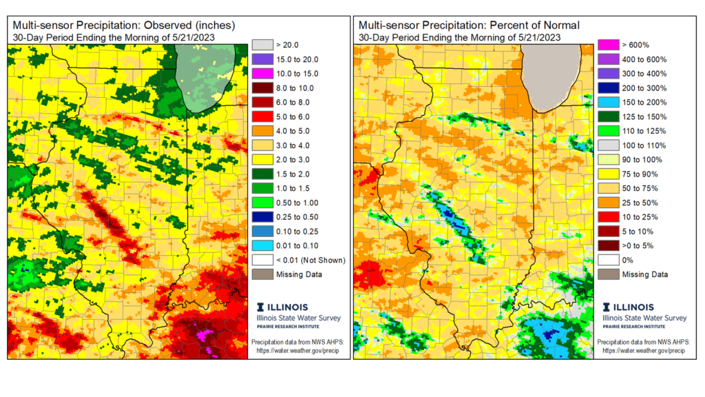
A dry pattern has been in place over Illinois since mid-April. Outside of a few areas of heavy rain, most places have had between 60% and 90% of normal precipitation in the last 30 days (Figure 1). Parts of central and western Illinois, the St. Louis Metro East, and virtually all of Chicagoland have had less than 50% of normal rainfall since April. As of May 22nd, Chicago has had only 0.42 inches of total May precipitation, more than 2 inches below normal by this time in May.
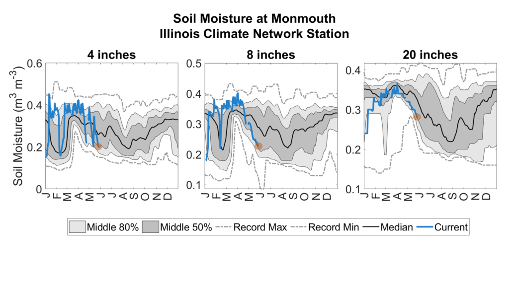
The combination of dryness and above average temperatures in May increased evaporation and plant water use, which depleted soil moisture. Figure 2 shows much drier than normal soils at 4-, 8-, and 20-inch depths at Monmouth, as part of the Illinois Climate Network. As of May 22nd, the top 20 inch soil column at Monmouth has 1-1.5 inches less water in it than normal for late May, meaning less water available for plant and crop use.
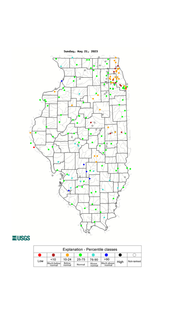
The lack of consistent rain and dry soils have acted together to reduce levels in some streams and rivers across northeast, central, and western Illinois (Figure 3). The orange and red dots in Figure 3 show places where stream levels are somewhat- to much-lower than normal for late May. Several streams in northeast and east-central Illinois have seen flow dip well below normal this month, including the Vermilion River at Pontiac and Lenore, the Illinois River at Marseilles and Henry, and the Sangamon River at Fisher and Monticello.
While the recent dryness is beginning to affect stream levels in Illinois, drought has not persisted enough to significantly affect water resources. Drought in Illinois typically impacts plants and crops first, as soil moisture is depleted; but can begin to impact water resources and water quality if it persists.
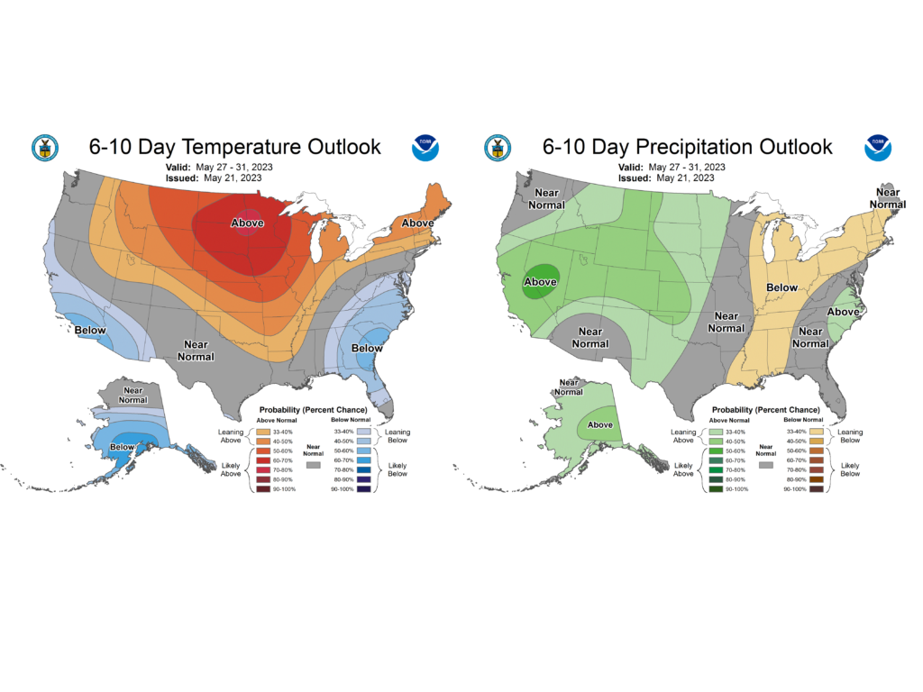
Dry & Warm End to May
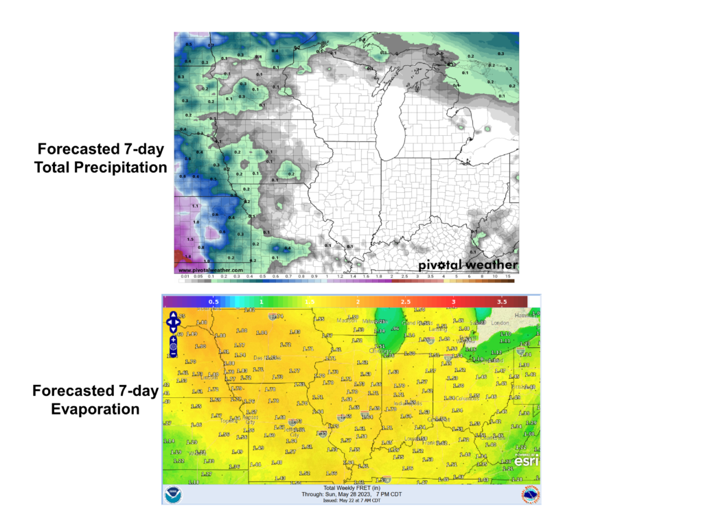
Current conditions show only small parts of Illinois are experiencing drought, although soils are drier than normal across much of central and northern Illinois, and streamflow is declining in these areas. The 7-day forecast from the National Weather Service shows very little – if any – rainfall across Illinois this week (Figure 4). Meanwhile, temperatures are expected to reach into the mid-80s and may even crack 90 degrees in some places this week and into next week. The result of higher temperatures and low humidity is increased evaporation and transpiration, which further deplete soil moisture. As Figure 4 shows, National Weather Service forecasts show between 1.5 and 1.75 inches of potential evaporation over the next 7-days, meaning the state would generally need that much rainfall to keep soil moisture conditions steady.
The NOAA Climate Prediction Center outlooks for the final week of May also lean warmer and drier than normal across the state. A potentially very dry and warm end to May would likely worsen already dry conditions, and push more of the state into drought, with potential impacts to perennials, vulnerable crops, and young trees. The Climate Prediction Center has also denoted a swath of the eastern corn belt that is at risk of rapid-onset or “flash” drought in the next 2 weeks because of the expected warmer and drier conditions (Figure 6).
What Can I do?
Drought is a tough hazard because of its relatively slow evolution (as compared to a tornado or blizzard, for example) and its complex impacts; however, there are important steps we can take before and during drought to minimize its impacts. The first impacts we typically see with drought are to vulnerable perennials, crops, and young trees. Folks should be extra aware of how dry soils are in their areas, and if possible, augment watering of sensitive shrubs, trees, and other perennials – especially if they begin to show water stress. Additionally, we should always conserve water and use it sustainably, but particularly so when in drought. While no water resource impacts have been reported in Illinois from the recent dryness, our water use can affect the severity of drought impacts.
Lastly, monitoring drought conditions across Illinois is challenging and time consuming because of its varied and sometimes subtle impacts. Likewise, it is just as important to know where drought is not as to know where drought is. Therefore, to help with the drought monitoring and impact assessment process, please consider regularly reporting conditions and any impacts (or lack thereof) in your part of the state. Reports can include how wet or dry is the environment around you (soils, lawn, gardens, etc.), are you seeing any impacts like trees drooping or dropping leaves and are creek- and stream-levels in your area near normal, above normal, or below normal for this time of the year.
Impact reports can be submitted through:
The National Drought Mitigation Center’s Condition Monitoring Observer Reporting (CMOR) system: https://droughtimpacts.unl.edu/Tools/ConditionMonitoringObservations.aspx,
or via email to the Illinois State Climatologist Office: statecli@isws.illinois.edu.
Also, if you observe precipitation for CoCoRaHS, please consider submitting a weekly condition monitoring report: https://www.cocorahs.org/content.aspx?page=condition. Every report makes a difference, and helps us understand drought conditions and can help direct help and resources where they need to go in the state.