

Drought re-intensified in Illinois at the end of the growing season and has increased the fire and blowing dust risk as we approach harvest. River levels have also dropped near or below low stage, increasing concerns of issues with navigation.
Working off Early August Rains
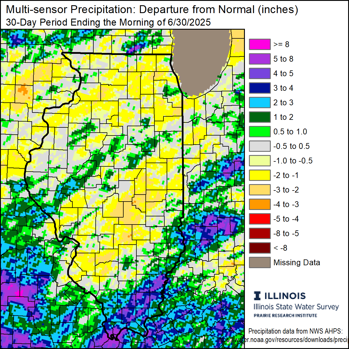
The drought peaked in early July for much of Illinois, as more active, stormy weather was present most of that month and in the first two weeks of August. Most of Illinois was 1 to 8 inches wetter than normal between mid-July and mid-August, dramatically improving soil moisture, crop conditions, and streamflow. However, drier weather has dominated since mid-August, and most of central and northern Illinois have been 1 to 4 inches drier than normal between mid-August and mid-September (Figure 1).
Soil moisture down to 20 inches has been depleted once again because of the below normal rainfall. The combination of dryness and late August heat has also sped up crop senescence and possibly affected some yields in the driest parts of the state. Meanwhile, crops in areas of the state that had been wetter in early August, such as parts of central and southern Illinois, have been relying on the remaining soil moisture.
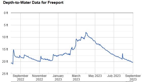
Water table levels have also dropped across the northern two-thirds of the state as soil moisture is used. Water table levels at the State Water Survey’s WARM station in Freeport dropped more than 1 foot between August 1 and September 1 (Figure 2), and current water table depths are 1.5 feet deeper than this time last year.
Low River Levels Across the Midwest
Drought usually affects the flow and level of small streams and creeks first, then the tributaries of our larger rivers. When dry conditions persist for weeks to months we can see low flow along our larger rivers like the Illinois, Rock, and Kaskaskia. When those drought conditions cover most of the Midwest region, we can see low flow along the region’s largest rivers like the Mississippi and Ohio. Persistently dry conditions this summer have caused concerns of low flow conditions along the Mississippi River, like the issues we saw last fall. As of September 15, the Mississippi at Memphis was 4 feet below low stage and forecasted to approach record low values by late September. The big river hit a record low of -10.81 feet on October 21, 2022, so it is concerning that we are approaching these low values a full month ahead of last year.
The problem of big river low flow is not as easily fixed as soil moisture drought. Most rain over the next few weeks would be soaked up by the soil to replenish soil moisture and groundwater, reducing runoff to the big rivers and their tributaries. Therefore, the Midwest region will need prolonged wetter conditions over the next several weeks to help reduce or avoid the impacts of low flow on our rivers.
Where are We Headed?
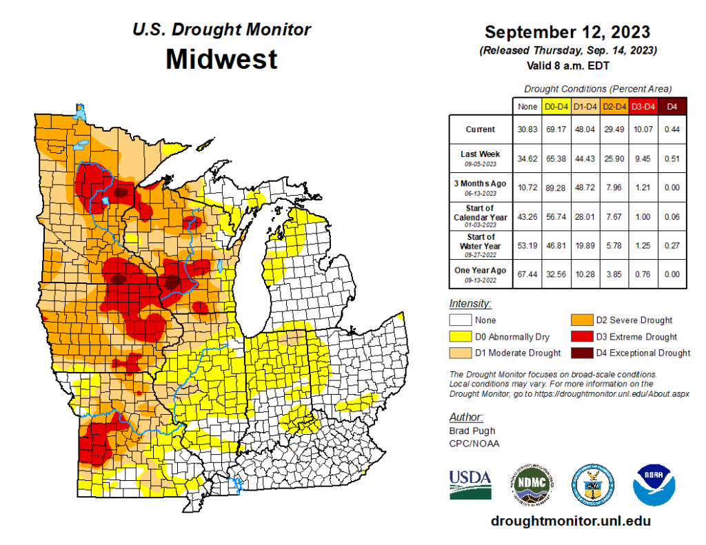
The September 12 edition of the U.S. Drought Monitor has over 20% of Illinois and nearly half of the Midwest region in at least moderate drought (Figure 3). Most of the worst drought issues are in the western Midwest, while the eastern corn belt remains mostly drought-free.
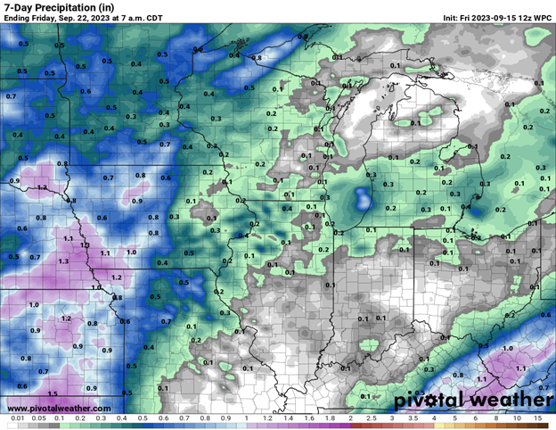
Next week looks to be very dry across most of the region, including the Ohio Valley region that often contributes significantly to the flow of the Ohio and lower Mississippi Rivers (Figure 4). Beyond that, outlooks show the best chances of warmer conditions returning for the last full week of September, but also possibly better chances of near to wetter than normal conditions in the Midwest.
Fire and Dust Risk
We are still a few weeks from harvest in full swing, but more combines are out of the shed–and some in the field–across southern and central Illinois. Recent dry weather has quickly dried corn and beans, and combined with low humidity and dry topsoil, has increased field and grass fires across the Midwest. Extra precautions should be taken ahead of, during, and after harvest to ensure everyone stays safe considering the enhanced fire risk. You can find more information on farm fire safety here: go.illinois.edu/farmfiresafety.
Additionally, the dry crop and topsoil increase the chances of blowing dust on dry and windy days. Folks should consider weather conditions and the potential dust created when harvesting. We want to avoid dangerous blowing dust situations like what we saw this spring.