A warm and dry first half of June has persisted or worsened drought conditions in northern Illinois. Here is an update of current conditions and a look ahead into this summer.
U.S. Drought Monitor
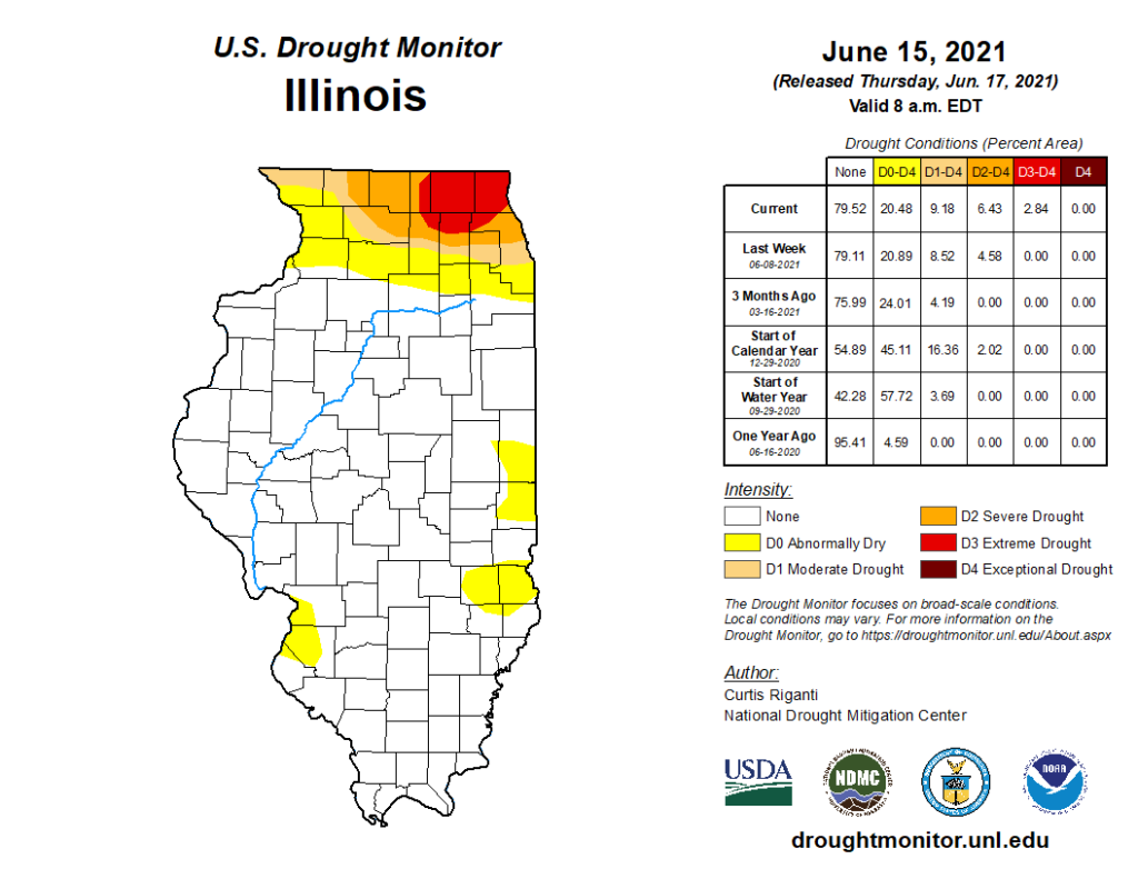
The latest version of the National Drought Mitigation Center’s U.S. Drought Monitor, which was current as of June 15th, showed an expansion of both moderate drought (D1) and severe drought (D2) across northern Illinois. The Drought Monitor also introduced extreme drought (D3) in all or parts of Lake, McHenry, Boone, DeKalb, Kane, and Cook Counties in northeast Illinois as well as in parts of southern Wisconsin. The last time the Drought Monitor showed extreme drought in any part of Illinois was October 2012. Currently, over 9% of the state is in at least moderate drought, over 6% of the state is suffering from severe drought, and nearly 3% of the state is now in extreme drought according to the U.S. Drought Monitor.
Precipitation Deficits
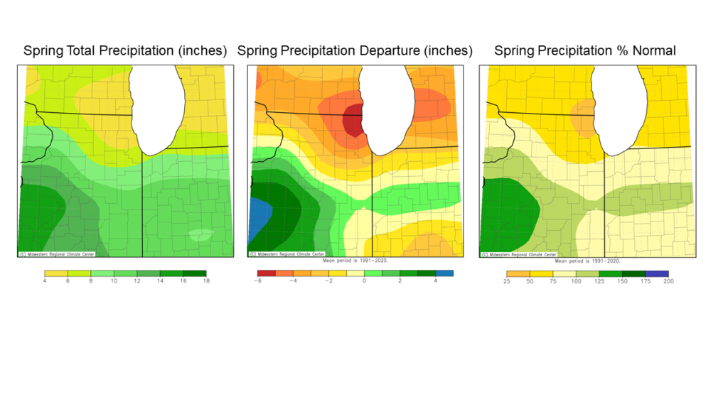
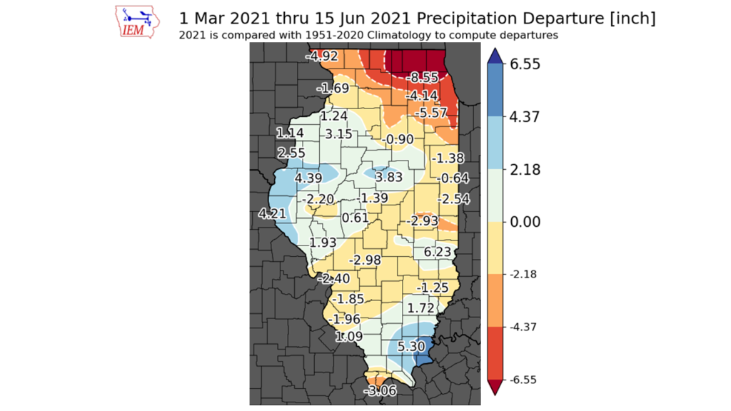
May wrapped up an extremely dry spring. The period March to May this year was the 3rd driest spring on record in Chicago and the driest since 1934. The maps below show spring precipitation in northern Illinois was 2 to 6 inches below the 1991-2020 normal, with the largest deficits in far northeast Illinois.
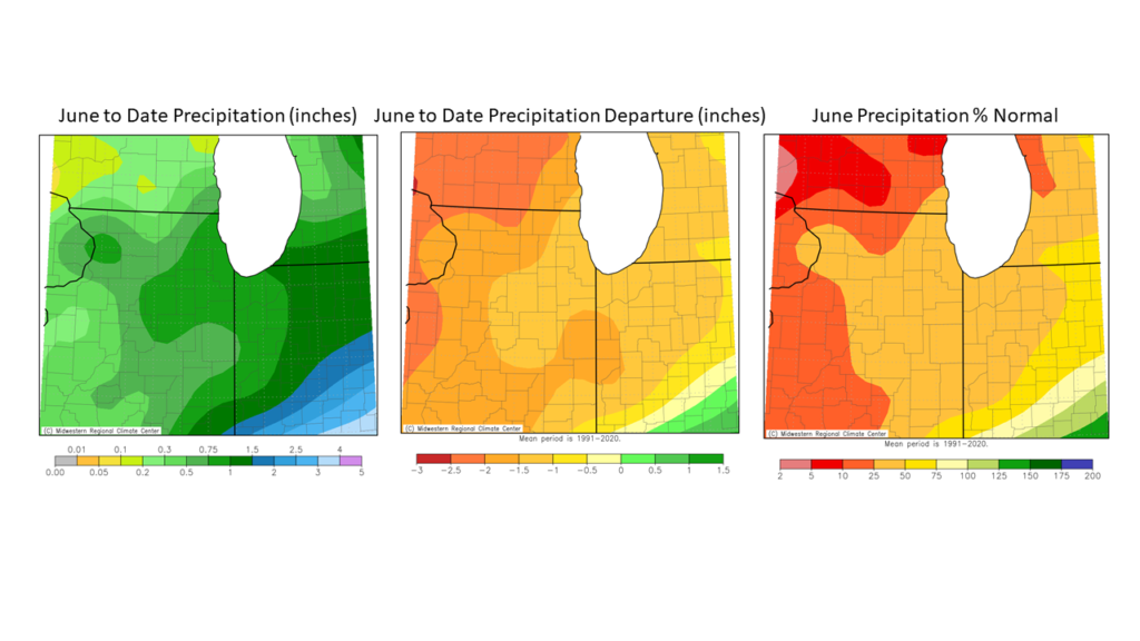
The dry weather pattern continued throughout the first half of June. The northern half of the state received between 0.5 inches and 2.5 inches below normal precipitation in the first half of June, between 10% and 50% of the 1991-2020 normal. The combination of spring and the first half of June has left northeast Illinois with an 8 to 10 inch precipitation deficit since March 1st, and northwest Illinois with a 4 to 6 inch precipitation deficit since March 1st (Figure 3).
June Heat Not Helping
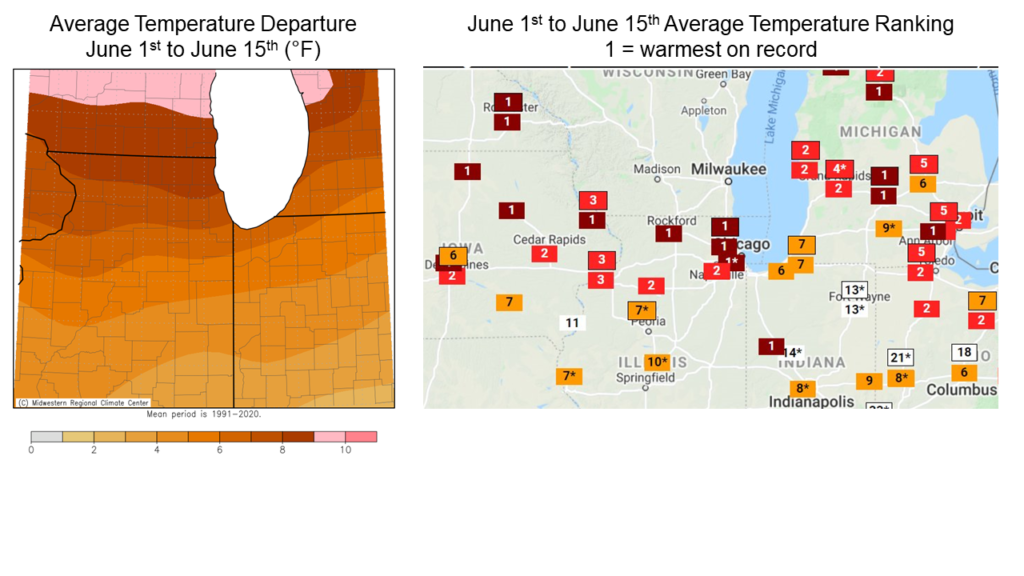
Extensive precipitation deficits have left parched soils and reduced flow in both small and large streams throughout northern Illinois. These impacts have been exacerbated by the extreme high temperatures in the region during the first half of June. Average temperatures in northern Illinois between June 1st and June 15th were between 6 and 10 degrees above the 1991 to 2020 normal. The first half of June was the warmest on record in Chicago and the third warmest on record in both Rockford and Moline; all three of these stations’ records stretch back to the 1870s. Very warm weather has increased evaporative demand on already dry soils and stressed vegetation and crops, worsening the drought conditions and associated agriculture, water resource, and ecological impacts.
Impacts So Far
The timing of this drought is different than the “droughts of record” of 1988 and 2012 such that the “peak” of those past droughts was later in the summer in July and August. The relatively early onset of this year’s drought has likely limited impacts to agriculture, water resources, and ecosystems so far. However, reports of impacts to crops in northern Illinois include corn plants curling leaves, early firing, and stunted growth in both corn and soybeans. Gardeners and horticulturalists across northern Illinois report having to water gardens and specialty crops much more frequently, and lawns, trees, and shrubs are reportedly showing significant drought stress in residential areas.
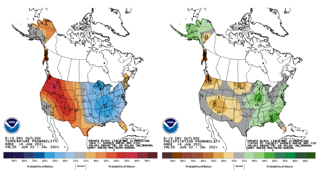
Outlook
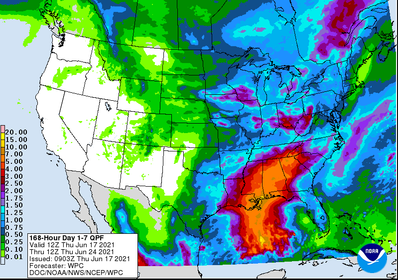
The June 17th National Weather Service precipitation forecast indicates the potential for widespread 1 to 2 inches accumulation across northern Illinois over the 7 days. It is understandable if folks are skeptical of the forecast, given how frequently wet forecasts have not come to fruition in northern Illinois over the past three months; however, this is the best chance for drought alleviation since mid-May. If the forecast does verify it will not eliminate drought in northern Illinois but will go a long way to improve soil moisture and reduce stress in crops and ecosystems.
Meanwhile, Climate Prediction Center outlooks indicate a tendency for cooler and wetter than normal conditions statewide in the third week of June. Both outlooks are potentially good news for drought affected areas, and we could see real improvement with soaking rains combined with below average evaporative demand from the cooler weather. However, many more weeks of wetter weather are needed to ameliorate drought in northern Illinois and stave off further impacts as we move into the heart of summer.