NOAA’s Climate Prediction Center issued new outlooks today for October and beyond. The latest outlook for October shows all of Illinois having increased chances of being both warmer and drier than normal.
BTW, this is the exact opposite of how last October turned out. The statewide precipitation total in October 2009 was 8.40 inches. That was 5.5 inches above normal and the 2nd wettest October on record. The statewide average temperature was 49.6 degrees. That was 4.6 degrees below normal and the 6th coldest on record.
The outlook for October-December shows all of Illinois having an increased chance of warmer than normal conditions. Precipitation has “equal chances” of being above, below, and near-normal, or what I call a neutral forecast.

Summer – One of the Warmest and Wettest on Record
Summer
This summer was one of the warmest and wettest in Illinois history, based on preliminary data. The average statewide temperature for this summer (June-August) was 76.4 degrees, 2.7 degrees above normal and the seventh warmest summer on record. The average statewide rainfall was 16.7 inches, 5.2 inches above normal and the sixth wettest summer on record. Statewide records for Illinois extend back to 1895.
August
The average statewide temperature for August was 76.8 degrees, 3.2 degrees above normal. That puts it at the 13th warmest August on record. August was on track to being even warmer but a late-month cool spell knocked it down a few notches in the ranking. August rainfall has been close to normal with a statewide average of 3.4 inches, just 0.3 inches below normal.
[This is an update of a post earlier in August, now removed to avoid confusion]
Maps for July 2010
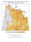
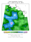
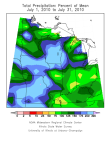
Here are the thumbnail maps (click to enlarge) of July temperature departures, and July rainfall and rainfall departures. It was warmer than normal across much of eastern Corn Belt. It was much wetter than normal across much of the western Corn Belt.


July – Warmer and Wetter than Normal
The average temperature for July in Illinois was 77.7 degrees, 1.9 degrees above normal. That’s warm but not record-breaking by any means. By contrast, the average temperature of last July was 70.2 degrees. Not only was this year warmer but it was considerably more humid as well.
The average rainfall for July in Illinois was 5.6 inches, 1.8 inches above normal. BTW, the wettest July on record was 1958 with 8.03 inches.
The largest rainfall totals occurred in western and far northern Illinois as well as an area along I-70. Amounts of 8 to 12 inches were common in these areas.
Southern Illinois was much drier in July with amounts of only 1 to 3 inches in many locations. In fact, the US Drought Monitor categorized southern Illinois as being “abnormally dry” by. Another area of dryness is through central Illinois in an area bound by Moline, Kankakee, Danville, Springfield, and Peoria.

