Based on preliminary numbers, the statewide average temperature for the first half of April is 54.0 degrees, 5.4 degrees above the 1971-2000 average.
The statewide average rainfall for the first half of April is 1.65 inches, 0.22 inches below average. Rainfall ranged from under an inch in far northern Illinois to over 2 inches in far southern Illinois (see map).

March – Near Average Temperature
Temperature
The statewide average temperature for Illinois in March was 41.0 degrees, just 0.1 degrees below the 1971-2000 average. Of course, temperatures varied widely from one week to the next. Take Chicago: on March 17, the high temperature was 67 degrees which is 20 degrees above average. A week later, the highs were in the low 30s and 11 to 12 degrees below average. Kaskaskia reported the highest temperature in Illinois for the month with 83 degrees, while Normal reported the lowest temperature for the month with 14 degrees.
Precipitation
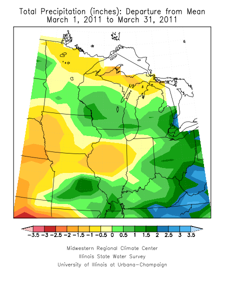
The statewide average precipitation for March was 2.76 inches, 0.45 inches below the 1971-2000 average. Amounts ranged from 2 to 3 inches in northern Illinois, to 1 to 2 inches in central Illinois, and 3 to 6 inches in southern Illinois. The heaviest rainfalls were in far southern Illinois with Brookport reporting a monthly total of 8.14 inches and Cairo reporting 7.36 inches.
Snowfall
It is not unusual to get snowfall in March. Average snowfall in March typically ranges from about 2 inches in Carbondale to over 5 inches in Rockford and Chicago. This year, the only significant snow fell near St. Louis. Lebanon to the east of St. Louis reported 8.0 inches of snow; Waterloo to the southeast of St. Louis reported 6.2 inches.
Figures


A Cold and Snowy Winter in Illinois
For anyone who lives in Illinois, it will come as no surprise that we were colder and snowier than normal this winter. The statewide average temperature for December-February was 24.9 degrees. That is 3.3 degrees below normal and the 17th coldest December-February since statewide record began in 1895. The coldest December-February in Illinois was 1977-78 with 19.6 degrees.
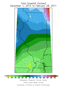
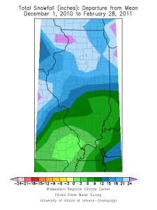
Snowfall for December-February ranged from 15 inches in southern Illinois to over 45 inches in northern Illinois (see maps below). According to the Lincoln NWS office, Peoria reported its snowiest December-February on record with 52.5 inches while Springfield reported its fifth snowiest December-February with 34.2 inches. According to the Chicago NWS office, Rockford reported its third snowiest December-February with 51.2 inches and Chicago reported its fifth snowiest December-February with 56.3 inches.
Precipitation (both rainfall and the water content of any snow) was near-normal. The statewide average precipitation was 6.90 inches, only 0.14 inches below normal.
Climatologists define winter as the months of December, January, and February because it lines up better with the kinds of weather we expect to see in winter. It’s better than the December 22 to March 22 definition, which is based on the winter solstice and the vernal equinox. In many cases in Illinois, we have already had several doses of winter weather by December 22 and winter weather is fading away once March arrives.
Tenth Wettest February for Illinois
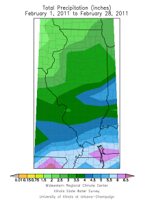
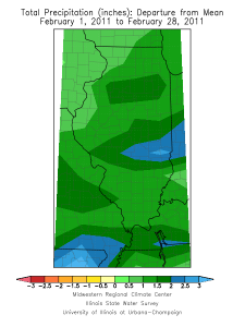
The statewide average precipitation in Illinois for February was 3.39 inches, 1.46 inches above normal and the tenth wettest February since statewide records began in 1895. Precipitation includes rainfall and the water content of any snow (and freezing rain, sleet, snow pellets as was the case in February). See maps below (click to enlarge). The highest monthly precipitation total in Illinois was 7.05 inches in Paris.
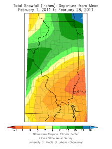
Snowfall was above normal in February across much of Illinois thanks to the February 1-2 winter storm. Snowfall totals for the month ranged from just under 4.5 inches in southeastern Illinois to over 20 inches across much of northern Illinois. The highest monthly snowfall total in Illinois was 30.5 inches in Spring Grove.
Some outstanding monthly snowfall totals include Chicago with their snowiest February on record with 29.0 inches; Rockford with their fifth snowiest February on record with 20.2 inches, Peoria with their second snowiest February on record with 20.9 inches, and Springfield with their fourth snowiest February on record with 16.5 inches.
The statewide average temperature in Illinois for February was 29.5 degrees, 0.7 degrees below normal. The highest temperature for February in Illinois was 78 degrees in Waterloo on February 21. The lowest temperature for February was -22 degrees in Elizabeth on February 10.
