Midwest Most Productive Region in the World

According to a press release from NASA …

Data from satellite sensors show that during the Northern Hemisphere’s growing season, the Midwest region of the United States boasts more photosynthetic activity than any other spot on Earth, according to NASA and university scientists.

They determined this by measuring the fluorescent glow that healthy plants give off when they grow. It is not visible to the human eye but can be picked up by special sensors on satellites. The press release has a lot more details.

If you click on the map, you can see the full version. While they don’t have any state boundaries, you can make out Lake Michigan. Based on that, it looks like one of the brightest areas is across central and northern Illinois – no surprise there.
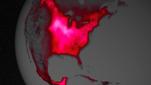
The magnitude of fluorescence portrayed in this visualization prompted researchers to take a closer look at the productivity of the U.S. Corn Belt. The glow represents fluorescence measured from land plants in early July, over a period from 2007 to 2011. Image Credit: NASA's Goddard Space Flight Center.
The magnitude of fluorescence portrayed in this visualization prompted researchers to take a closer look at the productivity of the U.S. Corn Belt. The glow represents fluorescence measured from land plants in early July, over a period from 2007 to 2011.
Image Credit: NASA’s Goddard Space Flight Center.
Wet June and Wettest Year-to-Date in Illinois

Based on preliminary numbers, the statewide average precipitation for June 2013 in Illinois was 5.19 inches. That was 0.99 inches above the 1981-2010 average. It was more than double the June 2012 total of 1.80 inches.
In the first map below, the two wettest areas in Illinois were in northern Illinois and an area just to the south of Interstate 70. The area in northern Illinois was part of a larger area of heavy amounts in northeastern Iowa and southern Wisconsin. The area in southern Illinois extended into southern Indiana and Kentucky. Both regions had rainfall totals in excess of 8 inches and even 10 or more inches in the red and purple areas.
By contrast, much of the rest of the state was close to average precipitation for June with 3 to 6 inches very common (shades of green on the map). The few areas in blue (representing less than 3 inches) in western and north central Illinois are not alarming yet because they followed a wet spring. In fact, much of the Midwest experienced a wet June, including the Ohio River Valley which experienced drier conditions early in the month.
The second map zooms in on Illinois and shows the departures from average for June. The wet areas in northern and south-central Illinois stand out with rainfall totals 3 to 5 inches above average. Areas in central and southwestern Illinois were below average.

30-day precipitation through the morning of June 30 for the Midwest.
30-day precipitation through the morning of June 30 for the Midwest. Click to enlarge.

June Precipitation Departure from Average.

 
The year to date (January-June) statewide precipitation for Illinois was 28.74. That was 8.91 inches above the 1981-2010 average and the wettest January-June on record. The statewide records go back to 1895. It is more than double the 12.67 inches accumulate in January-June of 2012 during the height of the drought.
The statewide average temperature was 71.5 degrees, which was 0.3 degrees below the 1981-2010 average.

Wettest Locations In Illinois in June

Location and June precipitation total in inches, ranked high to low. List cut off for sites with less than 5 inches to keep the list somewhat short.
                    FLORA 12.63
     BELLEVILLE SCOTT AFB 12.34
     BELLEVILLE SIU RSRCH 10.97
              CARY 0.3 NE 10.72
         BROOKPORT DAM 52 10.37
        CENTREVILLE 1.9 E 10.33
               STEWARD 3S 9.78
     MCHENRY STRATTON L&D 9.69
              TROY 1.4 SE 9.68
              CARY 1.9 NE 9.62
           YORKVILLE 3 SW 9.5
       BELLEVILLE 4.5 WNW 9.35
              HIDALGO 3SW 9.3
          CLAY CITY 6 SSE 9.16
             PALESTINE 2W 9.02
               GREENVILLE 9.01
      WHITE HEATH 3.7 NNE 8.99
             CAPRON 0.1 N 8.79
      LAWRENCEVILLE RIVER 8.76
           AVISTON 0.4 NW 8.73
                 OLNEY 2S 8.7
        BELLEVILLE 2.2 SE 8.67
              ROSCOE 2 SE 8.66
          ROCKFORD 3.3 NE 8.54
                BELVIDERE 8.5
           CHAMPAIGN 9 SW 8.49
                 KINMUNDY 8.46
         WOODSTOCK 0.7 SW 8.44
         BELKNAP 11.1 ESE 8.42
        MASCOUTAH 0.5 WSW 8.39
     EDWARDSVILLE 0.9 WSW 8.32
     HAWTHORN WOODS 0.6 N 8.3
                    SALEM 8.27
     GRANITE CITY 1.4 ENE 8.26
             ATWOOD 0.4 N 8.24
         SHERIDAN 0.1 SSW 8.23
                 ROBINSON 8.21
      WONDER LAKE 0.8 WNW 8.17
                  HARVARD 8.16
               ALBERS 1 W 8.16
                 HIGHLAND 8.11
          ROCKFORD 0.7 NW 8.09
           PALATINE 1.3 E 8.07
       ORANGEVILLE 2.8 NW 8.04
          ALGONQUIN 0.7 N 7.98
                    CASEY 7.87
       PARK RIDGE 0.7 WNW 7.87
             CARLYLE RSVR 7.82
       HARRISBURG 4.6 NNE 7.77
                ELIZABETH 7.76
 ROCKFORD GTR ROCKFORD AP 7.72
           SHABBONA 5 NNE 7.72
               CHARLESTON 7.64
         OKAWVILLE 2.3 SW 7.58
                  MATTOON 7.52
         CHARLESTON 1.0 S 7.51
             FREEPORT WWP 7.5
             SPRING GROVE 7.5
         EDWARDSVILLE 2 W 7.43
          MARSEILLES LOCK 7.42
                  DE KALB 7.38
            SMITHLAND L&D 7.36
           STOCKTON 3 NNE 7.35
            DE KALB 1.4 W 7.35
             DIXON 1.5 SW 7.33
                 VANDALIA 7.33
         PECATONICA 2.3 S 7.32
 ARLINGTON HEIGHTS 1.2 SW 7.29
        MANSFIELD 3.0 WSW 7.29
          WINSLOW 4.3 ESE 7.29
                  MARENGO 7.28
              SHABBONA 3S 7.23
            DUNLAP 2.6 NE 7.21
         CHARLESTON 0.9 S 7.2
           FARMER CITY 3W 7.19
                  TUSCOLA 7.18
           WOODSTOCK 5 NW 7.17
                  WINDSOR 7.09
      BUFFALO GROVE 1.5 N 7.07
              DAVIS 0.5 N 7.04
          BARRINGTON 3 SW 6.99
ARLINGTON HEIGHTS 1.8 NNW 6.98
          ROCKTON 1.0 ESE 6.97
     LINCOLNSHIRE 1.3 WSW 6.96
 ST. FRANCISVILLE 2.3 NNW 6.96
            EARLVILLE 3 S 6.96
           MARSHALL 4.6 W 6.89
                  PAW PAW 6.85
          CHAMPAIGN 3.6 W 6.83
                CENTRALIA 6.82
            WATSON 0.3 NE 6.81
           PEORIA 3.4 WNW 6.8
         ROCKFORD 1.5 ENE 6.79
             EFFINGHAM SE 6.74
       NEW MILLFORD 3.3 W 6.74
        CHAMPAIGN 2.3 NNW 6.7
                     IUKA 6.69
      LAWRENCEVILLE 1.4 W 6.68
      BULL VALLEY 2.5 WNW 6.67
       MONTGOMERY 1.7 SSE 6.65
                   GALENA 6.63
             MT OLIVE 1 E 6.63
        CHAMPAIGN 2.5 WNW 6.59
        CHAMPAIGN 0.3 ESE 6.55
        CHAMPAIGN 3.5 SSE 6.54
               TRIMBLE 1E 6.52
         WINNETKA 0.8 ESE 6.52
         SHERIDAN 3.4 SSE 6.51
           ASHTON 0.4 SSW 6.51
                    NEOGA 6.5
          FREEPORT 2.0 NW 6.5
                  ST ANNE 6.47
             MENDOTA 2 SE 6.45
             GALENA 5.7 E 6.43
              CAIRO RIVER 6.37
          YORKVILLE 1.1 W 6.33
          TUSCOLA 1.4 NNE 6.25
                CAIRO 3 N 6.24
    CHICAGO OHARE INTL AP 6.23
       RIVERWOODS 0.4 ENE 6.23
                NEOGA 4NW 6.22
             RED BUD 5 SE 6.22
            LISBON 4.4 NE 6.22
            MATTOON 1.3 W 6.21
                   URBANA 6.2
              BYRON 3.2 N 6.2
       MONTGOMERY 0.8 SSE 6.2
          LAKEMOOR 1.5 SE 6.19
 MOLINE QUAD CITY INTL AP 6.14
                    AMBOY 6.06
          MUNDELEIN 4 WSW 6.05
                   AURORA 6.04
       GRAND CHAIN DAM 53 6.03
                   HAVANA 6.03
      BANNOCKBURN 0.5 ESE 5.99
                   FISHER 5.98
            DIXON 3.0 NNW 5.95
 CHICAGO BOTANICAL GARDEN 5.94
          CHICAGO 5.5 ESE 5.93
       LINCOLNSHIRE 0.9 N 5.92
           ASHLEY 1.4 NNE 5.89
       PLAINFIELD 2.4 SSE 5.88
      KANKAKEE METRO WWTP 5.88
              SAVOY 0.9 N 5.86
               MT CARROLL 5.83
 CHANNAHON DRESDEN ISLAND 5.81
        LINCOLNWOOD 1.8 E 5.8
         EVANSTON 1.2 SSE 5.78
         PETERSBURG 7.5 W 5.73
                   MORRIS 5.71
               NEW ATHENS 5.71
        CHANNAHON 0.8 NNE 5.7
                  ROANOKE 5.69
      VILLA GROVE 0.6 ESE 5.69
        MARSEILLES 2.8 NW 5.68
        MOUNT OLIVE 0.4 S 5.65
       MARSEILLES 5.6 WNW 5.64
           GLENCOE 0.1 NW 5.63
           MORRIS 4.8 NNW 5.62
            NASHVILLE 1 E 5.6
          PEOTONE 0.4 ENE 5.6
       BROADLANDS 0.1 SSW 5.55
                  BUFFALO 5.54
        PLAINFIELD 1.1 SW 5.53
             GIRARD 1.2 W 5.49
     SHAWNEETOWN OLD TOWN 5.47
             SIDNEY 0.9 N 5.46
  HARWOOD HEIGHTS 1.9 NNE 5.46
             URBANA 1.8 N 5.45
     FAIRFIELD RADIO WFIW 5.43
        PLAINFIELD 4.8 SW 5.43
              KEWANEE 1 E 5.42
           COLETA 1.4 SSW 5.42
                   HARDIN 5.41
                  CHESTER 5.41
           LE ROY 4.1 SSW 5.41
                   RIPLEY 5.4
             EMDEN 2.4 SW 5.36
       MONTICELLO 3.5 NNE 5.36
           OSWEGO 5.0 SSE 5.35
               PEORIA 5NW 5.35
          KANKAKEE 3.2 SE 5.35
            SPARLAND 6 SW 5.33
         CHADWICK 2.7 WSW 5.32
      SUGAR GROVE 1.4 ENE 5.3
                  RANTOUL 5.3
                EFFINGHAM 5.23
                  DECATUR 5.22
            AURORA 3.8 SE 5.21
             MILFORD 5 NW 5.19
            AMBOY 0.5 ESE 5.18
                 ROCHELLE 5.18
        LONDON MILLS 1 SW 5.16
           SPARTA 1.9 SSW 5.16
     KASKASKIA RIV NAV LO 5.15
             AURORA 3.4 W 5.14
          PEOTONE 0.5 ENE 5.13
         CHAMPAIGN 0.7 SW 5.12
            PHILO 1.9 ENE 5.11
          PLAINFIELD 3 NE 5.1
           MINOOKA 0.3 NE 5.06
                    CISCO 5.05
            AURORA 3.6 SE 5.05
ELK GROVE VILLAGE 0.6 ESE 5.04
        CHANNAHON 2.5 SSE 5.03
           MENDOTA 2.4 SE 5.02
           PEOTONE 0.5 SE 5.02
           JACKSONVILLE 2 5.01
               MONEE RSVR 5

Dry Across the Midwest – 2012 Compared to 1988

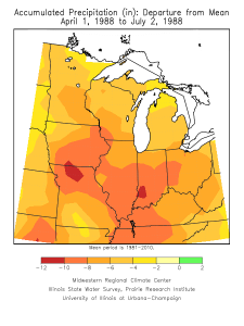
The current drought condition has many similarities with 1988. Here is the departure from normal precipitation for the Midwest from April 1 to July 2 for 2012 (left) and for 1988 (right).
Areas in green are doing well. Areas in blue are having to deal with flooding issues. Areas in yellow are dry, and areas in the darker shades of yellow, orange, and red are progressively drier.
This year the drought has missed parts of Minnesota, Wisconsin, and Michigan, where all the Midwestern states suffered in 1988. So far this year, the hardest hit area is in southern Illinois, southwest Indiana, western Kentucky and southeastern Missouri with departures of 8 to 12 inches (dark orange and red areas) since April 1. In 1988, those same conditions were seen over a wider area including large parts of northern Missouri, Iowa, Illinois, Indiana, western Kentucky, and eastern Ohio.

2012 (click to enlarge)

1988 (click to enlarge)