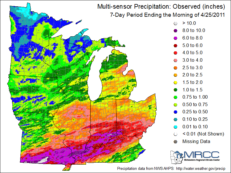
Heavy rains fell across southern Illinois over the last week. Amounts of 4 to 8 inches were common in areas from Carbondale southward (see map). In addition, heavy rains fell in southern Missouri, southern Indiana, southern Ohio, and large portions of northern Kentucky. As a result, minor to major flooding was reported along the Mississippi and Ohio Rivers as well as many of their tributaries.
You can track current river observations and flood stage forecasts at NWS website: http://water.weather.gov/ahps/

Heavy Rains Alleviate Illinois Drought
Heavy rains over the weekend put a major dent in the drought in southern Illinois and neighboring states. Amounts of two to four and a half inches were common throughout the southern half of the state. Some places saw more rain in the last week than in the last three months. For example, Mt Carmel reported 5.07 inches in the last 7 days while receiving a combined total of only 4.34 inches during the months of August, September, and October.
These widespread rains should give relief to other drought-stricken areas of the Midwest as well, including Missouri, Kentucky, Indiana, and Ohio.

Tropical Storm Hermine Reaches Illinois
The remains of Tropical Storm Hermine have reached Illinois this morning. Rainfall amounts of 1 to 3 inches are possible and flash flood warnings have been issued. Check the National Weather Service as this event unfolds.
While we don’t often use the words “tropical” and “Illinois” in the same sentence, the remains of tropical storms and hurricanes have reached us before. Most of these systems came on shore in Texas and Louisiana and weakened considerably as they moved northward. Usually, the severe weather is gone by the time they reach Illinois but they can produce large amounts of rain than can lead to flooding.
The passage of four tropical systems alleviated drought impacts, particularly in southern and central Illinois during the 2005 growing season. The four systems were Tropical Storm Arlene, and Hurricanes Dennis, Katrina, and Rita. An article in the Illinois State Academy of Science by me described that situation in more detail.
More recently, in September 2008 the remains of Hurricanes Ike and Gustav produced heavy rains and flooding in Illinois. More on that particular situation can be found on my website.
Rainfall Totals for July in the Chicago Area
Here are some rainfall totals for July 2010 [updated on August 3] for the Chicago area. This is preliminary and may contain missing or incorrect data. Missing data can make the monthly totals too low. Based on what has been reported so far, Midway Airport has set a new record for July precipitation, beating the old record of 8.98 inches set in 1957.
| Station | Total Precipitation |
|---|---|
| BARRINGTON 3 SW | 7.18 |
| BELVIDERE | 7.24 |
| CHICAGO BOTANICAL GARDEN | 5.51 |
| CHICAGO MIDWAY AP | 10.39 |
| CHICAGO MIDWAY AP 3 SW | 9.17 |
| CHICAGO OHARE INTL AP | 8.84 |
| DE KALB | 6.92 |
| EARLVILLE 3 S | 3.31 |
| ELBURN | 6.28 |
| ELGIN | 7.68 |
| GENOA 2 SW | 8.89 |
| GLEN ELLYN 4 S | 7.48 |
| HARVARD | 9.52 |
| JOLIET BRANDON RD DM | 5.00 |
| MARENGO | 6.53 |
| MARSEILLES LOCK | 3.87 |
| MCHENRY STRATTON L | 3.28 |
| MENDOTA 2 SE | 3.29 |
| MONEE RSVR | 6.01 |
| MORRIS | 3.89 |
| MUNDELEIN 4 WSW | 7.06 |
| NEWARK 2 SSE | 3.91 |
| OAK BROOK 2W | 9.02 |
| PARK FOREST | 6.38 |
| PERU | 2.74 |
| PLAINFIELD 3 NE | 7.48 |
| ROMEOVILLE LEWIS UNIV AP | 8.05 |
| SHABBONA 3S | 5.29 |
| SPRING GROVE | 6.89 |
| ST CHARLES 7 NW | 9.44 |
| STREAMWOOD | 6.91 |
| WHEATON 3 SE | 6.25 |
| WOODSTOCK 5 NW | 6.65 |
| YORKVILLE 3 SW | 4.31 |

