Based on preliminary data, the statewide average temperature for the first half of June was 73.4 degrees, 3.3 degrees above normal.
The statewide average rainfall for the first half of June was 3.85 inches, 1.78 inches above normal. Much of the southern and northern thirds of the state were near normal while central Illinois was much above normal.
The wettest areas are in a region between Quincy and the Quad Cities (again) and in east-central Illinois. For June 1-15, the following rainfall totals were reported: Moline with 4.35 inches, Quincy with 4.78 inches, Springfield with 3.85 inches, Champaign with 4.88 inches , and a CoCoRaHS observer in Sidney (SE of Champaign) with 7.84 inches.
The National Weather Service provides a high-resolution precipitation product that combines both rain gauge and radar data. It can be found at http://water.weather.gov/precip/. Here is the rainfall departure map for June 1-15, 2010, clearly showing the heavy rain areas in western and east-central Illinois.
More rains are falling in Illinois while this is being written on the afternoon of June 15.

May Finished both Wetter and Warmer
For Illinois, the preliminary statewide average temperature was 64.1 degrees, 1.3 degrees above normal. Basically the first 17 days of the month ran on the cool side (1.4 degrees below normal) while the rest of the month ran on the warm side (4.8 degrees above normal). The map below shows the temperature departures.
The statewide average rainfall was 5.68 inches, 1.42 inches above normal or 133% of normal. The heaviest amounts for the month were in western Illinois between Quincy and the Quad Cities. Dallas City, along the Mississippi River, reported 9.07 inches for the month.


Warmer Conditions Prevail in Late May
After a cold start to May (see earlier post), the period between May 18 and 27 was much warmer. The statewide average temperature during this period was 3.7 degrees above normal. The earlier cold period and this later warm period will pretty much cancel out, leaving May temperatures close to normal as we near the end of the month.
The statewide rainfall for the month is at 5.48 inches, 1.71 inches above normal. While wetter than normal, this is a long ways from the record May rainfall for Illinois of 8.87 inches set in 1943.
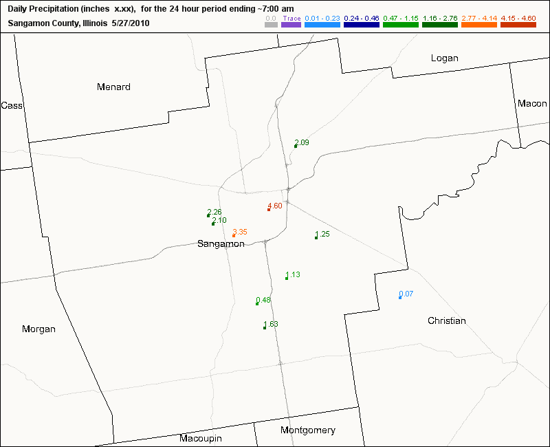
On a personal note, I drove through Springfield on I-72 on the afternoon of May 26 when a severe thunderstorm developed over the city. According to CoCoRaHS weather observers in Springfield, rainfall reports ranged from 2.10 on the far west side to 4.60 inches in the east-central side of the city – all in less than 2 hours (see map). I drove through wind-driven rain, lightning, and pea-sized hail. The flooding along the I-72 and I-55 entrance and exit ramps was impressive but conditions were even worse in town.


