New Climate Outlook for July and Summer – OK for Illinois

Today (June 19) the NOAA Climate Prediction Center has released their latest outlook for July and the rest of the year. One of the factors to come into play this fall and winter is the developing El Niño event in the Pacific Ocean. Unshaded areas show an equal chance (EC) of above, below, or near-average conditions. Click on any map to enlarge.

JULY

For July, we have EC for both temperature and precipitation in Illinois, except for a slight risk of below-average precipitation in southern Illinois. We are sandwiched between cooler than average conditions in the north and warmer that average conditions in the south.

off14_tempoff14_prcp


JULY-SEPTEMBER

For July through September we have EC for both temperature and precipitation in Illinois. From the standpoint of the Corn Belt, the increased chance of cooler than average temperatures in WI, MN, and the Dakotas through September may spell trouble for getting the corn crop to mature in time this fall. Wetter than average conditions are expected in the central West, which could bring some relief to drought conditions in that region.

off01_tempoff01_prcp


DECEMBER-FEBRUARY

For December through February, the core winter months, Illinois and much of the northern half of the US has an increased chance of above-average temperatures. This forecast reflects the expectation that El Niño will arrive. El Niño tends to bring milder temperatures in winter for Illinois and wetter conditions in the Southwest and Southeast.

off05_tempoff05_prcp

New Forecast for the 2014 Growing Season

Today the NWS Climate Prediction Center (CPC) released their forecast for May and beyond. There is nothing much to report for Illinois. We are in the area labeled EC for both temperature and precipitation for May and May-July. EC stands for equal chances of above-, below-, and near-average conditions. I consider that a neutral forecast without any solid evidence for unusual conditions to crop up (heat, drought, etc.).

While not shown here, the August-October maps are just as exciting for Illinois – EC for both temperature and precipitation. At least they have taken out the “increased chances of below-normal temperatures” that have been prevalent in recent months. While there has been some press about the potential arrival of El Niño this summer, the current thinking at CPC is that the effects will be minimal until later in the year.

Meanwhile, the latest 6-10 and 8-14 days forecasts (below) from the Climate Prediction Center show increased odds for both warmer and wetter than average conditions in Illinois. The warmer temperatures are welcome for warming up the soils (see Illinois soil temperatures). However, the increased chances for rain could be a problem for field work.

page2
Click to enlarge.

6-10 Day Forecast (click to enlarge)

610temp.new610prcp.new


8-14 Day Forecast (click to enlarge)

814temp.new814prcp.new

New NOAA Climate and Flood Outlooks

Happy Spring Equinox!

Seasonal Temperature and Precipitation Outlooks

There were a lot of new outlooks released today from NOAA. First are the new temperature and precipitation outlooks for April and this spring. It looks like the below-average temperatures are likely to continue in April. We have had below-average temperatures in Illinois for every month since November.

The April-June outlook has northern Illinois with an increased chance of below-average temperatures. Areas labeled E.C. mean that there are equal chances of above-, below-, or near-average temperatures or precipitation (depending on the map type).

page2
NWS Climate Prediction Center outlooks. Click to enlarge.

Spring Flooding Risk

The second major announcement is the spring flood outlook.

sfo_full

In the article, they say,

An unusually cold and wet winter across the Upper Mississippi Basin, Great Lakes region, Ohio River Valley, northern Middle Atlantic, New York and New England has produced an above normal amount of water in the current snowpack and a deep layer of frozen ground much further south than typical. With significant frozen ground in these areas, the flood risk is highly dependent on the amount of future rainfall and the rate of snowmelt this spring. Recent snowmelt has increased the near surface soil moisture and elevated the potential for rapid runoff from rain events. In addition, significant river ice increases the risk of flooding related to ice jams and ice jam breakups.

Moderate flooding is expected in southern Wisconsin, southern Michigan and portions of Iowa, Illinois and Indiana, as a result of water in the current snowpack and the deep layer of frozen ground coupled with expected seasonal temperatures and rainfall. Specific rivers at risk include the Mississippi River between Davenport, Iowa and Burlington, Iowa, the Illinois River between Beardstown, Illinois and Henry, Illinois and many smaller rivers in the area. In addition, a potential for exceeding minor river flood levels exists across the upper Midwest and east into New England.
New NWS Outlooks for June and June-August

Today, the NWS Climate Prediction Center released their temperature and precipitation outlooks for June and June-August and beyond. You can see their full suite of outlooks here.

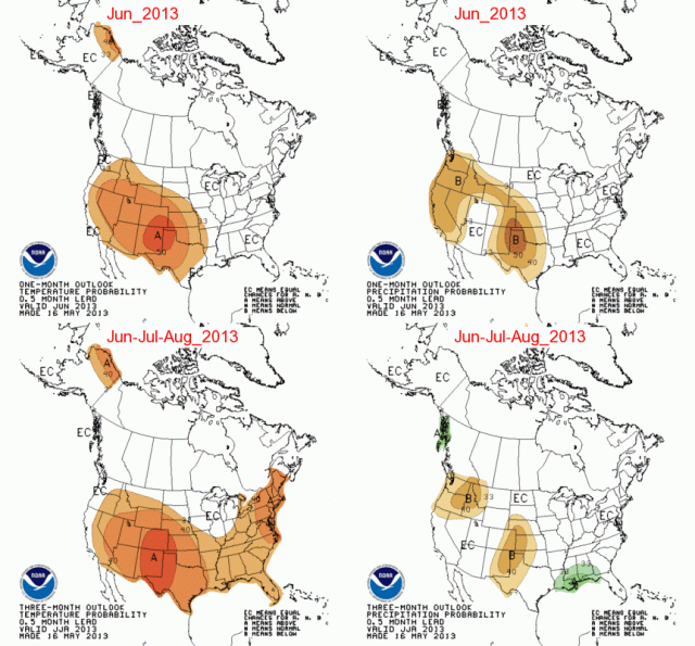
There isn’t much to report for Illinois (below). We are in the EC zone which means we have equal chances of above, below, and near-average temperatures and precipitation for the next three months. The only exception is that far southern Illinois has a slightly higher chance of above-average temperatures for June-August.

NWS Climate Prediction Center outlooks released May 16, 2013.
NWS Climate Prediction Center outlooks released May 16, 2013. Click to enlarge.