Rest of March – Cold, Wet; April-June – Wet According to NWS

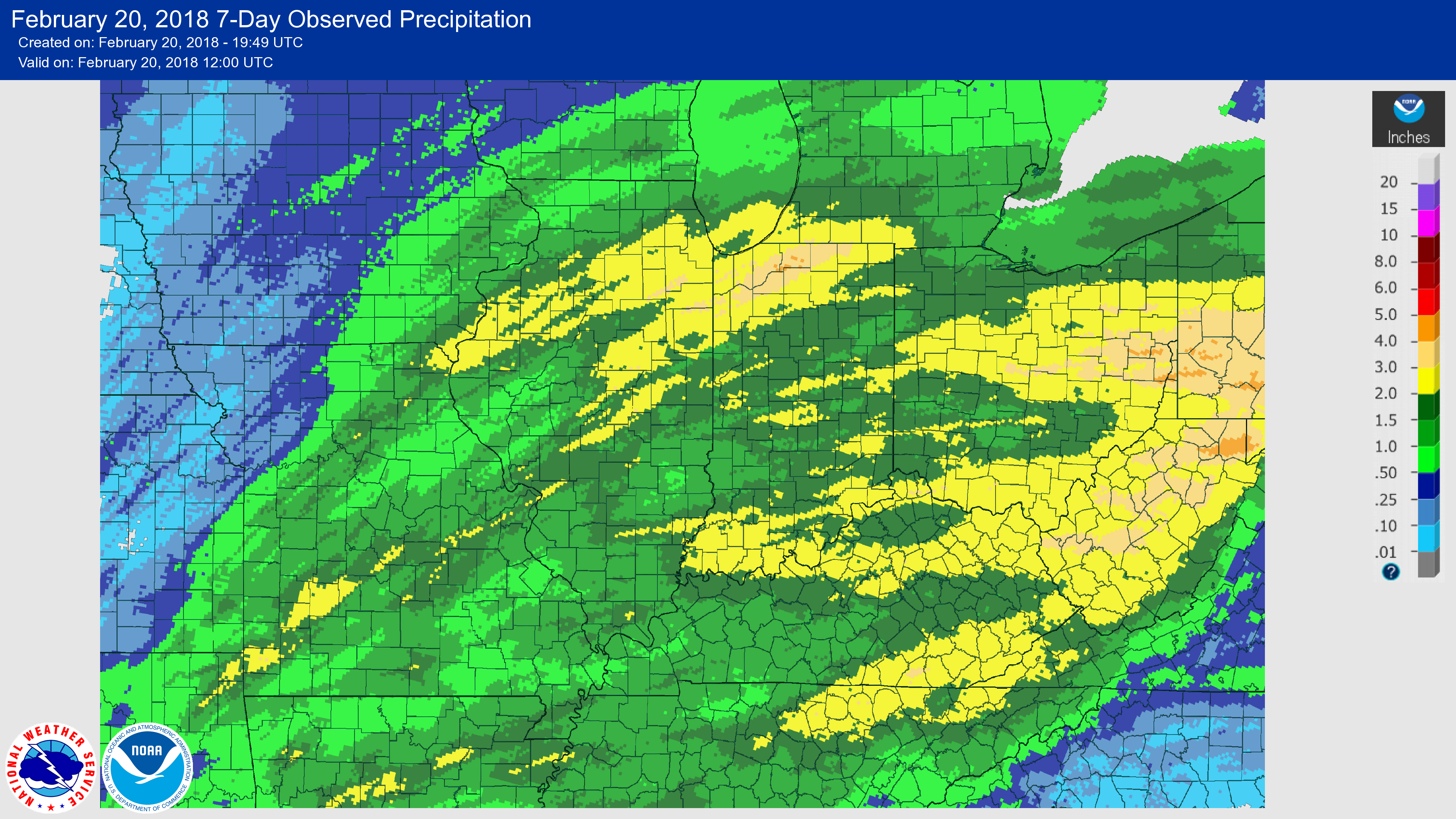
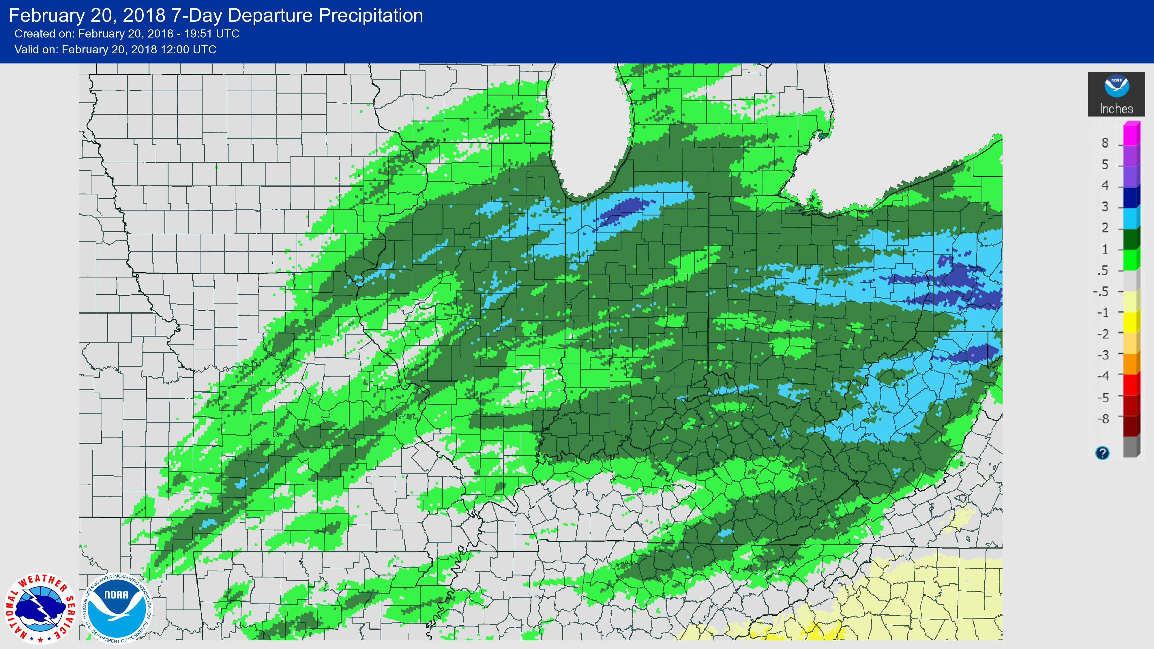
The NWS Climate Prediction Center released their latest outlooks for March, April, and beyond. So far, March has been cooler and drier than normal. The statewide average temperature was 36.8 degrees, which is about a degree below normal, while the statewide average precipitation was 1 inch, about 70% of normal.
Rest of March: there is an increased chance that the rest of March will be both colder and wetter than normal, according to the NWS forecast that extends out to 14 days. Here are the maps for the 8-14 day period. The 6-10 day maps are nearly identical. The expected colder and wetter conditions are widespread across the Midwest.


April: the outlook for April resembles the waning stages of a typical La Niña event. The southern third of Illinois has an increased chance of being warmer and wetter than normal. There are no strong climate signals for the rest of the state. Continue reading “Rest of March – Cold, Wet; April-June – Wet According to NWS”

Record Wet February in Illinois

Highlights: Based on preliminary data, the statewide average precipitation (rain and water content of snow) was 5.0 inches for February, 2.9 inches above normal and the wettest February on record. It beat the old record of 4.4 inches set back in 2008.  Statewide records go back to 1895. The highest monthly snowfall total for the month was Aurora with 26 inches. The warmest reading was 83 degrees at Belleville on 2/15 while the coldest reading was -16 degrees at Fulton on 2/7.

Precipitation

Below are the precipitation maps for February in Illinois (click to enlarge). The left panel shows the observed precipitation while the right panel shows the departures from normal (1981-2010 average). Areas in the shades of red to purple received 5 to 10 inches of precipitation for the month. That’s about 3 to 8 inches above normal. Areas that received only 3 to 5 inches include far western and northern Illinois and that was still above normal for February. The highest reported monthly total was Streator with 11.45 inches, followed by Cobden with 10.88 inches. Continue reading “Record Wet February in Illinois”

From Drought to Flood Worries in Illinois

Illinois has had a quite the shift in the weather pattern in the last few days with widespread rains across the state, including areas that have been dry for some time. Here are the rainfall totals for the past 7 days as of this morning (February 20th), both observed and departures from normal. In the top map, areas in yellow received between 2 and 3 inches. Many areas of the rest of the state received between 1 and 2 inches. As the bottom map shows, that’s above normal for this time of year, especially in the areas that received 2 to 3 inches of rain.
February 20, 2018 7-Day Observed PrecipitationFebruary 20, 2018 7-Day Departure Precipitation
Precipitation Forecast: And it continues to rain as I write this. Many areas in northern and central Illinois are currently in a flood watch or warning, according to the National Weather Service. And more rainfall is on the way. Here are the potential rainfall totals over the next five days. Southern Illinois could see between 5 and 7 inches while central Illinois could see 2 to 5 inches. Northern Illinois could see between 0.75 and 2 inches, depending on where you are. Continue reading “From Drought to Flood Worries in Illinois”

Outlook for Spring and Summer from NWS

The new outlooks for March, Spring, and Summer from the National Weather Service’s Climate Prediction Center are out.  You can click on any map to see the larger version.
Overview: The NWS says that La Nina conditions continued through January and into early February across the equatorial Pacific Ocean, as indicated by oceanic and atmospheric observations. The CPC/IRI consensus ENSO forecast indicates that La Nina conditions are expected to decay rapidly and transition to ENSO-neutral conditions during Spring. ENSO-neutral conditions are favored to persist through at least the summer.

March

Parts of Illinois shaded in blue have an increased chance of colder than normal conditions. This is part of a larger area of expected colder conditions that extend from the Midwest westward and is a classic La Nina signal for this region. Current climate conditions do not favor colder or warmer than normal conditions in the rest of Illinois. Current climate conditions do not favor wetter or drier than normal conditions in Illinois in March.

March-April-May

Continue reading “Outlook for Spring and Summer from NWS”