The preliminary statewide average December temperature was 29.4 degrees, 0.6 degrees below the 1991–2020 average and the 61st coldest on record going back to 1895. The preliminary statewide average total December precipitation was 2.62 inches, 0.21 inches above the 1991–2020 average and 43rd wettest on record statewide.
Data are provisional and may change slightly over time.
Unusual Extreme Cold in Late December
December 2021 was the second warmest on record in Illinois. The unusually warm December weather was accompanied by tornado outbreaks, extreme rainfall, and the latest first measurable snowfall on record in Chicago (December 28th). This year was quite a bit different, with much closer to, in not slightly warmer than normal temperatures in the first half of the month, followed by an extreme cold outbreak and rapid warmup in the second half. The plot of daily temperature departures from normal in Peoria shows the intensity of cold around Christmas, and how quickly extremely cold air was replaced with much warmer weather. In fact, Peoria went from -33 degree temperature anomalies on December 23rd to +26 degree temperature anomalies on December 29th, the quickest the city has experienced this magnitude of change on its 140+ year record.
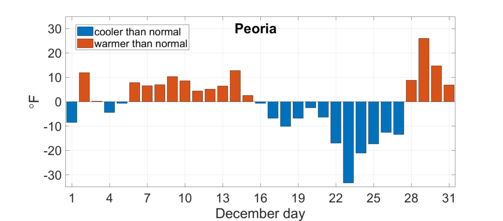
Figure 1. Daily December average temperature departures in Peoria.
A strong winter storm moved through the Midwest in late December, bringing extremely cold Arctic air into the region. Actual temperatures recorded in Illinois in the final two weeks of the month include -15 degrees in Knox and Mercer Counties, -12 degrees in Lee and Cook Counties, and -11 in McLean and Champaign Counties. Combined with 25+ mph sustained winds and 45+ mph wind gusts, wind chill values were in the -25 to -40 degree range. The extreme temperatures and wind chill values are very unusual for late December, only occurring in northern and central Illinois once every 20 to 25 years. As often happens, a strong ridge followed the intense trough in the jet stream, and the state warmed up quickly in the last week of the month. High temperatures ranged from the low 50s to mid-60s, between 10 and 25 degrees above normal.
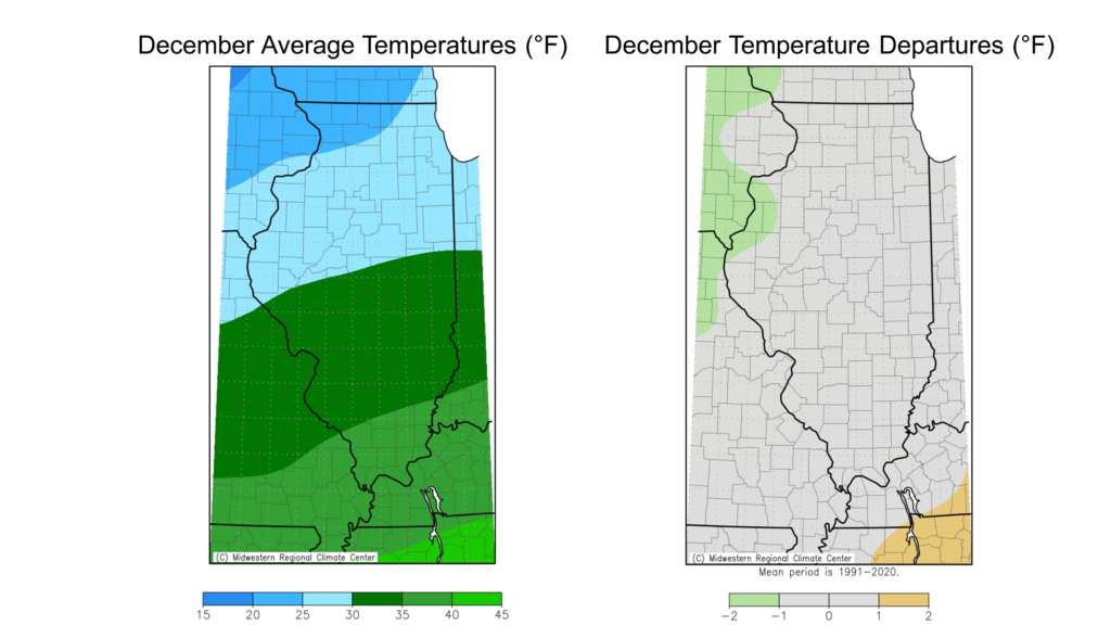
When taken altogether, December average temperatures ranged from the low 20s in northern Illinois to the high 30s in southern Illinois, within 1 degree of normal (Figure 2). The warmest place in the state last month was Olmsted in Pulaski County with an average December temperature of 37.1 degrees. The coolest place in the state was Elizabeth in Jo Daviess County with an average December temperature of 22.4 degrees.
While no daily high maximum temperature records were broken last month, daily high minimum temperature records were broken at two stations. Meanwhile, the extreme cold in late December broke low maximum temperature records at 11 stations and low minimum temperature records at 5 stations. The station in Robinson in Crawford County set a new all-time December low temperature record of -9 degrees, breaking the old record of -8 degrees set in 1901.
Overall, the preliminary statewide average December temperature was 29.4 degrees, 0.6 degrees below the 1991–2020 average and the 61st coldest on record going back to 1895.statewide.
Some Rain, Some Snow, and a White Christmas (for some)
Most of the state entered the first month of climatological winter drier than normal with some parts of southern Illinois having precipitation deficits of 8 to 10 inches going back to the summer. While December didn’t eliminate drought issues, the near normal precipitation last month put us on the road to drought improvement.
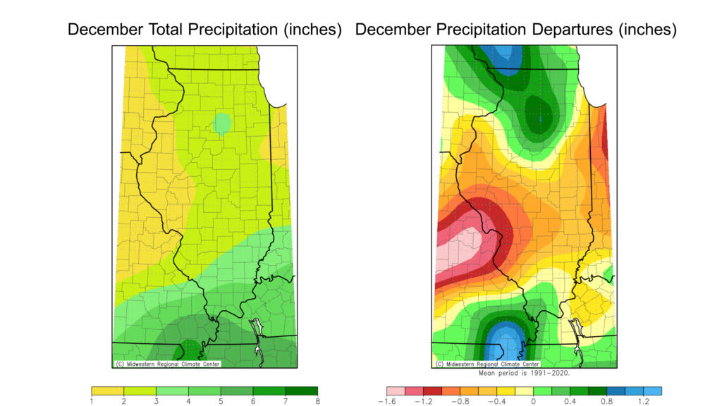
December total precipitation ranged from just under 2 inches in western Illinois to over 5 inches in far southern Illinois. Most of central and south-central Illinois was 0.5 to 1.5 inches drier than normal last month, while northern and southern Illinois were 0.5 to 1.5 inches wetter than normal. December was the first wetter than normal month since July in parts of far southern Illinois.
Overall, the preliminary statewide average total December precipitation was 2.62 inches, 0.21 inches above the 1991–2020 average and 43rd wettest on record statewide.
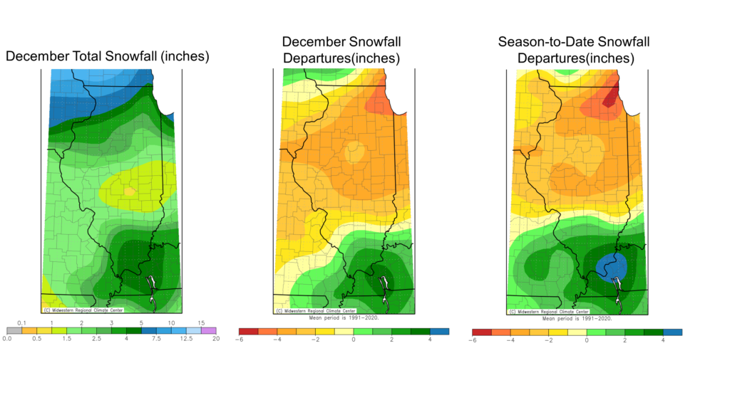
While the extreme temperatures and wind were the main storylines of the winter storm in late December, the storm did bring modest snowfall to the northern two-thirds of the state. A weaker storm system moved through the mid-South in early December, making for a snowier than normal December in southern Illinois, while snowfall totals were 1 to 5 inches below normal north of Interstate 64. The same snowfall pattern exists for the winter season to date, with areas north (south) of Interstate 64 having 1 to 5 inches below (above) normal snowfall.
Outlooks
Climate Prediction Center outlooks for January lean into a late-blooming La Niña-esque pattern, leaning to warmer and wetter than normal weather to kick off 2023 (Figure 6).
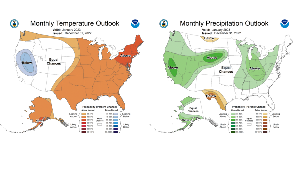
Figure 6. Maps show (left) temperature and (right) precipitation outlooks for January.
