
Summary: There is a big shift in the weather pattern coming to Illinois as a strong cold front moves through Illinois on Friday and Saturday. Behind it will be cooler, less humid air. In fact, cooler temperatures are expected to dominate in Illinois over the next few weeks.
For the weekend and next week, daytime highs will range from the 70s in northern Illinois, the 70s and low 80s in central Illinois, and low 80s in southern Illinois. Overnight lows will range from the mid-50s to low 60s in northern and central Illinois, and in the low to mid-60s in southern Illinois.
Here is what temperatures on Sunday afternoon are expected to look like – not bad for early August and more like the first week of September.

Mid-Range Forecasts
Here are the 6-10 day, and 8-14 day forecasts from the NWS. All of these maps are expressed as departures from normal. All that blue shading means that below-normal temperatures are expected across Illinois and much of the US for the next 14 days. Meanwhile, parts of the West Coast swelters with exceptional heat. Does this pattern look familiar? It should, it was the basic pattern for most of 2014 with heat in the West and cool temperatures across the central US.


August Monthly Forecast
Because of the recent pattern shift, the NWS has revised their forecast for August. The western half of Illinois, as well as points westward, have an increased chance of below-normal temperatures. Personally, I would say that all of Illinois has an increased chance of ending up below-normal in August, based on the forecasts over the next 2 weeks. It will be interesting to see if the pattern remains in the second half of August.

Does a cooler August increase our risk of an early frost? No.
Based on past experience, temperatures in August have little relevance to the risk of early frost. The only risk is indirect – a cool August could cause crop development to lag behind, resulting to later maturity in the fall and bumping up against normal fall frost dates in October. This may be especially critical in fields that were (re)planted late due to spring conditions. I would be most concerned in northern Illinois where the growing season is always much tighter than southern or central Illinois.
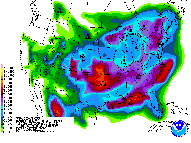
Precipitation
Over the next few days, the cold front moving through Illinois will initiate precipitation throughout the state. The expected rainfall totals across Illinois will be modest over the next 7 days – ranging from about 1 inch in the north to 1.5 inches in the south. Local amounts could be much heavier. The models out to 14 days show several more opportunities for rainfall – nothing spectacular but nevertheless helpful for crops in central and southern Illinois without washing away northern Illinois. At the same time, the cooler temperatures will lower the demands on soil moisture for a while.
 US Drought Monitor
The US Drought Monitor introduced D1 “moderate drought” conditions in St. Clair and Monroe Counties this week. If you have any drought impacts, please let me know either in the comments section or sending me email at jimangel@illinois.edu Thank you.
