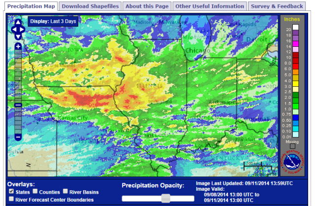
Heavy rains have fallen in western and central Illinois over the last three days. Here is the overall picture showing the heavy rains in southern Iowa and northern Missouri as well. Areas in yellow, orange, and red experienced 2.5 to 8 inches of rain. Much of the rest of Illinois received 1 to 2 inches.

The largest three-day total comes out of Rushville with 8.06 inches with most of that falling on one day (6.96 inches on September 10). To put that in perspective, the average September rainfall at Rushville is 3.65 inches. So this three-day period was over twice the average for the entire month.
Several other nearby sites reported amounts in the 4 to 6.5 inch range, including:
- Mt. Sterling with 6.40 inches
- St. David with 6.13 inches
- La Harpe with 6.00 inches
- Griggsville with 5.50 inches
- Macomb with 4.80 inches
- Jacksonville with 4.46 inches
- Quincy with 4.45 inches
Here is a closer look at the 3-day rainfall amounts in Illinois.


Of course, this has had a dramatic effect on local rivers and streams. Here is a plot of the gage height on the La Moine River, at Colmar, IL, over the last 8 days. In general, water levels in rivers and streams in Illinois are at their lowest this time of year, as you can see before the recent rains.

