Champaign-Urbana Winter Weather Stats

Below is a summary of the February and winter weather statistics for Champaign-Urbana:

February

  • The average temperature for February was 19.0 degrees, which was 9.9 degrees below average and the 9th coldest on record.
  • The total snowfall for February was 14.6 inches, which was 8.8 inches above average and the 10th snowiest on record.

Winter

  • The average temperature for the three core winter months of December, January, and February, was 21.6 degrees, which was 8.6 degrees below average and the 9th coldest on average.
  • Our seasonal snowfall total that goes all the way back to November, was 41.1 inches as of March 3. That makes it the 7th snowiest seasonal total on record and 17.9 inches above the seasonal average of 23.2 inches.

It was certainly a cold and snowy winter but it was hard to beat those winters in the late 1970s and early 1980s. For example, the winter of 1977-78 experienced the most snow in Champaign-Urbana history with 67.2 inches. It was also the coldest during the December-February period at 20.2 degrees.

The official NWS cooperative observer site is located at the Illinois State Water Survey near the corner of First and Windsor in Champaign.
The Tale of Two Winters – One Dry, One Wet

We have had a remarkable contrast in the last two winters in terms of precipitation. While both winters have been relatively quiet in terms of snow (at least up until the last week), this winter has made up for it in rainfall.
Here are the January 1 to February 25 precipitation departure maps for 2012 (first figure) and 2013 (second figure) for the Midwest. Precipitation is the combination of rainfall and the water content of any snow/sleet/freezing rain events.
Areas in shades of yellow show below-average precipitation while areas in shades of green show above-average precipitation. As you can see, the widespread yellow in 2012 was replaced with widespread green in 2013. This is good news for Illinois and for the Midwest.
First two months of 2012.
First two months of 2013.

Latest Outlook for this Winter in Illinois

The NWS Climate Prediction Center posted their latest outlook for December and December – February (winter). The temperature outlook for December is for equal chances (EC) for above, below, and near-normal temperatures. The precipitation outlook for December is a little more interesting with an increased chance of above normal precipitation in the southern half of Illinois. The rest of the state is in the EC category.
There is not much to report on the December-February outlook for Illinois with the state in EC for both temperature and precipitation, except for an increased chance of above-normal precipitation in far southern Illinois.
Part of the reason for the bland outlooks is that the Climate Prediction Center expects near-normal temperatures in the eastern Pacific Ocean along the equator. That means there is no El Niño or La Niña expected for this winter.
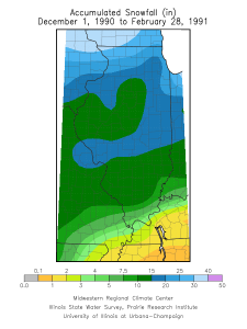
I looked at three winters that had a similar setup in the Pacific Ocean (slightly raised sea-surface temperatures but not a full-blown El Niño event). They are the winters of 1979-80, 1990-91, and 2003-04. In Illinois, each of these winter were slightly warmer than normal – on average by half a degree. Two out of the three had below-average precipitation (1979-80 was 2.2 inches short, 2003-04 was 1.3 inches short, while 1990-91 was 1.4 inches above).  All three had below-average snowfall in the north. However, two out of three had above-average snowfall in southern Illinois (1979-80 and 1990-91). See the maps below for more details on snowfall.

Climate Prediction Center outlook for December and December-February. Click to enlarge.

Winter 1979-80 snowfall. Click to enlarge.

Winter 1979-80 snowfall departures. Click to enlarge.

Winter 1990-91 snowfall. Click to enlarge.

Winter 1990-91 snowfall departures. Click to enlarge.

Winter 2003-04 snowfall. Click to enlarge.

Winter 2003-04 snowfall departures. Click to enlarge.

NOAA Winter Forecast

Back on October 18, NOAA released their winter forecast. There was nothing too exciting for Illinois. Illinois has equal chances of above, below, and near-normal temperatures. The same is true for precipitation, except along the westward edge of Illinois which has a slightly increased risk of below-normal precipitation. See maps below.
If you look at the past dozen years in Illinois, winter-time temperatures have been consistent at being inconsistent (see graph). We have had some really mild winters in 2001-2002 and this last winter. On the other hand, we have had harsh winters including the three before this last winter.
Just to give you an idea of what is “normal” or average about Illinois, here is the link to the monthly and seasonal precipitation, temperature, and snowfall across Illinois.

Winter temperatures in Illinois for past 12 years. The departure is from the 1971-2000 period. The double date represents December of the first year and January and February of the second year.

NWS Winter Temperature Outlook.

NWS Winter Precipitation Outlook.