The NWS Climate Prediction Center posted their latest outlook for December and December – February (winter). The temperature outlook for December is for equal chances (EC) for above, below, and near-normal temperatures. The precipitation outlook for December is a little more interesting with an increased chance of above normal precipitation in the southern half of Illinois. The rest of the state is in the EC category.
There is not much to report on the December-February outlook for Illinois with the state in EC for both temperature and precipitation, except for an increased chance of above-normal precipitation in far southern Illinois.
Part of the reason for the bland outlooks is that the Climate Prediction Center expects near-normal temperatures in the eastern Pacific Ocean along the equator. That means there is no El Niño or La Niña expected for this winter.
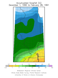
I looked at three winters that had a similar setup in the Pacific Ocean (slightly raised sea-surface temperatures but not a full-blown El Niño event). They are the winters of 1979-80, 1990-91, and 2003-04. In Illinois, each of these winter were slightly warmer than normal – on average by half a degree. Two out of the three had below-average precipitation (1979-80 was 2.2 inches short, 2003-04 was 1.3 inches short, while 1990-91 was 1.4 inches above). All three had below-average snowfall in the north. However, two out of three had above-average snowfall in southern Illinois (1979-80 and 1990-91). See the maps below for more details on snowfall.


