We just updated the odds of a white Christmas in Illinois, based on 1981-2010 data. We created the map using stations that had at least 20 years of snowfall data during the 1981-2010 period. A year with a white Christmas was defined as having measurable snow on the ground on December 25.
There can be large differences from site to site. Snowfall is notoriously difficult to measures with two nearby sites having different results due to exposure to sun and wind. In general, the odds are about 40-50 percent in the northern third of Illinois, 20-40 percent in central Illinois, and 0-20 percent in southern Illinois.

December snowfall in Illinois
The new 1981-2010 normal snowfall data have been released by the National Climatic Data Center. A map of those data for December are shown below. Normal snowfall ranges from barely an inch in far southern Illinois to 8 – 11 inches in many places in northern Illinois. Antioch is the snowiest station with 11.1 inches in December. Besides the total snowfall for the month, you can get maps of number of days with 0.1 inches or more, 1 inch or more, and 10 inches or more.
While southern Illinois gets less snowfall in December, they get more rain. In fact, the map of total precipitation (rainfall plus the water content of snow) shows that southern Illinois is almost twice as wet as northern Illinois. Normal precipitation amounts of 4 to 4.5 inches are common there, compared to around 2 inches for sites in northern Illinois. See second map.
So why is northern Illinois so “dry” compared to southern Illinois in terms of precipitation, even though northern Illinois gets much more snow? It turns out that the water content in snow is not that great. The rule of thumb is that 10 inches of snow melts into 1 inch of water (10:1). However, the actual ratio varies from storm to storm. I have seen the ratio vary from 4:1 for a wet, slushy snow to 20:1 for a light, powdery snow. So that 8 inches of snow in your driveway may not have any more water in it than the rain from a typical summertime thunderstorm.
You can explore all the new normals data in maps and tables for each station at the climate normals page on the State Climatologists website.


November Snowfall in Illinois
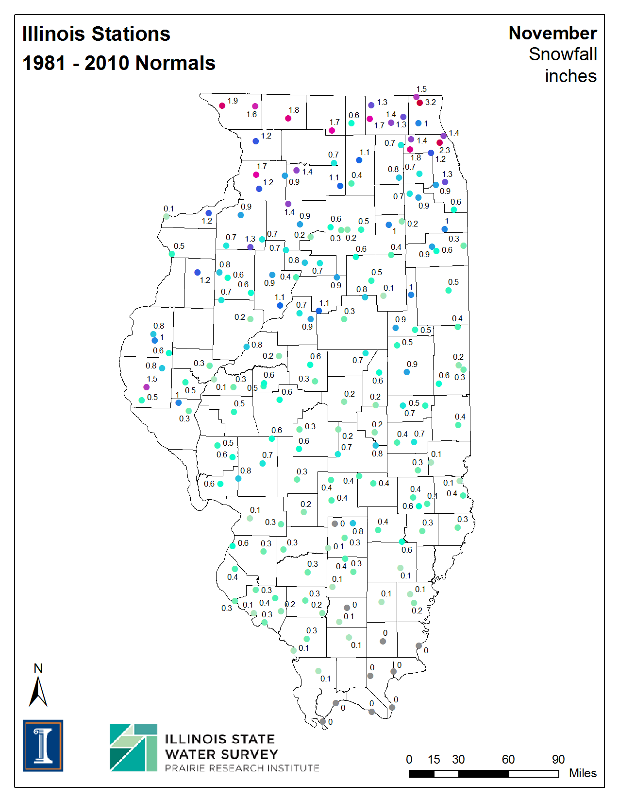
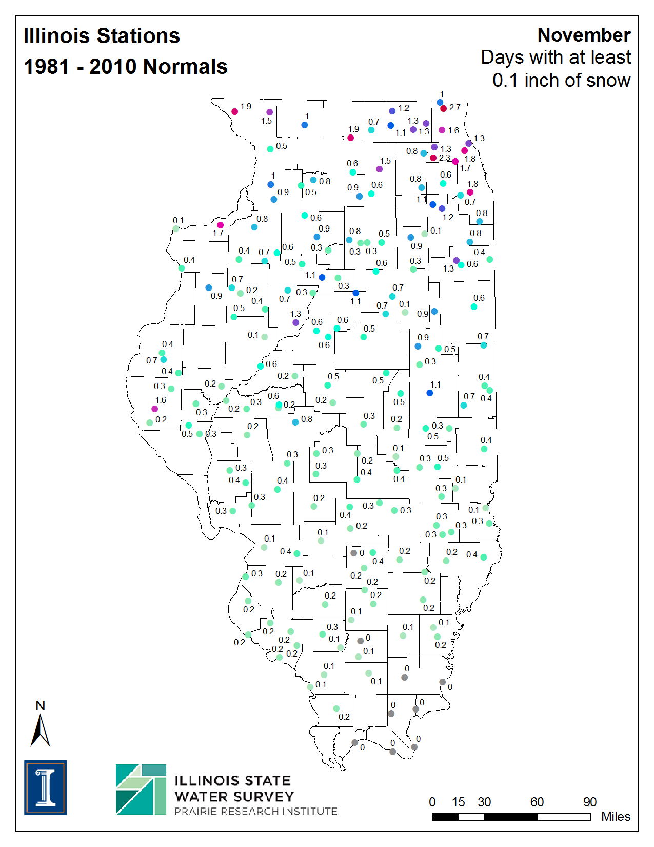
We have generated maps of the new 1981-2010 normals for Illinois, including the new November snowfall normals and the number of days with “measurable” snowfall (0.1 inches or more). See the maps below (click to enlarge).
While we may sometimes see snow in late October, November is normally the start to the snowfall season for much of Illinois. However, the average amounts are small by the standard of later winter months, ranging from 1-2 inches in northern Illinois to less than an inch in central Illinois to zero in southeastern Illinois.
The number of days with measurable snowfall, or snowfall frequency, is uncannily like the snowfall totals. The snowfall frequency ranges from 1-2 days for November in northern Illinois, to less than a day in central Illinois, to zero in southeastern Illinois. When the frequency drops below one day it means snowfall does not occur every year. For example, an average frequency of 0.5 days means it happens only once every 2 years on average.


2011: A Year of Extremes
I think we will remember 2011 as a year of extreme events. In Illinois we have already faced a February blizzard, flooding, record rainfalls, drought, and a heat wave. The latest newsletter of the NOAA’s Regional Climate Centers Program has highlighted several major events from around the country, including:
- wildfires
- tornadoes
- spring flooding in the Midwest
- record flooding in the Missouri River Basin
- drought
- snow
Check it out. I don’t know about anyone else but I’m ready for a quiet fall.
BTW, the Midwestern Regional Climate Center is housed at the Illinois State Water Survey.

