June rainfall has been well above average for much of Illinois. Rainfall amounts in the 3 to 8 inch range were common in the last 14 days (yellow to red in the map below). The relatively driest part of the state was the northwest corner where amounts were less than 2 inches. Heavy rainfall amounts were reported in Missouri, southern Iowa, and Indiana as well.

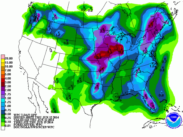
The NWS precipitation forecast for the next 7 days (map below) shows more opportunities for rain, especially in northern Illinois. The 6-10 day and 8-14 day forecast show an increased chance of wetter-than-average conditions for Illinois and the eastern Cornbelt.
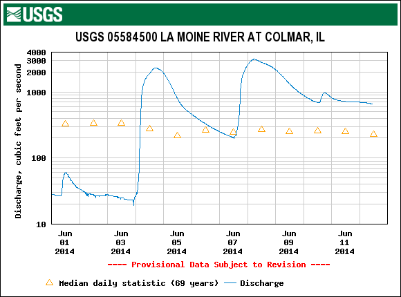
At the beginning of June we had some concerns for western Illinois, especially with low river and stream flows and short to very short subsoil moisture (below 6 inches). The recent rains have improved the situation to some degree. For example, the La Moine River at Collmar IL USGS stream gauge increased from 30 cubic feet per second on June 1 to 3,000 cubic feet per second on June 8, a one-hundred fold increase in flow (figure below).
The last USDA report from June 9 showed widespread improvements in topsoil moisture. In fact, 12 percent of the state reported excess topsoil moisture. I suspect that percentage would be even higher now. However, subsoil moisture in western Illinois improved only slightly, suggesting that much of the rain ran off into the streams and rivers instead of recharging the deeper layers of the soil.


 The good news of sorts is that much of the upper Midwest, including northern Illinois has been dry for the last 3-4 months. In the last few weeks, what snow cover we had in the central US is gone, as this map shows.

