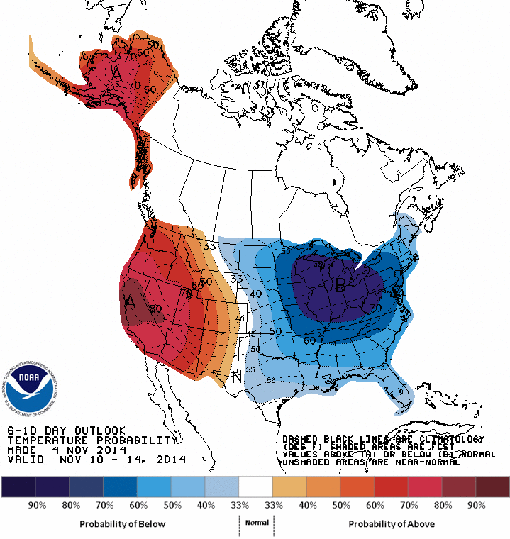
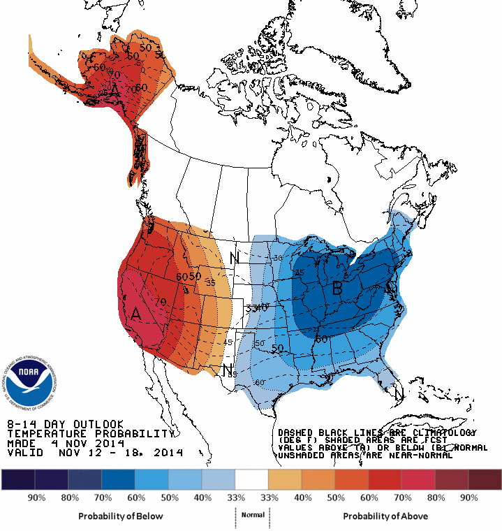
So far, November has been cooler than average across Illinois and the eastern two-thirds of the Midwest (below). The statewide average temperature is about 5 degrees below average.
The NWS forecasts indicate that temperatures are likely to stay below-average for the next two weeks across Illinois and the Midwest. The second and third maps are the latest NWS 6-10 and 8-14 day forecasts.
The statewide average precipitation for November was only 1.26 inches. That is 36 percent of normal or 2.21 inches below normal. It ranks as the 17th driest November on record since 1895. The maps below show the distribution around the state and how it compares to normal (1981-2010 average).
The statewide average precipitation from January to November was only 27.6, nearly 10 inches below the normal of 37.5 inches. What does this mean for the drought? The recovery that began in late August and through October in much of the state has stalled out.
The statewide average temperature for November was 40.8 degrees, 1.1 degrees below normal.
November was an interesting month in Illinois. The four outstanding features were:
the sixth wettest November on record with a statewide average precipitation amount of 5.23 inches, 1.9 inches above average; several sites in southern Illinois had over 9 inches of rain, including Cairo with 9.92 inches (the most of any site in the state);
the end of drought for western and central Illinois as a result of the above average rainfall in November;
the ninth warmest November on record with a statewide average temperature of 45.3 degrees, 3.6 degrees above average;
the snowiest spot in the state was in far southern Illinois, 2.5 inches of snow fell by the morning of November 30 at Grand Chain Dam on the Ohio River. A few sites in northern Illinois reported an inch or less of snow. As was noted in an earlier post, the “normal” snowfall for November ranges from 1 to 2 inches in northern Illinois to no snowfall in southern Illinois – the near opposite of this year. It is just another example of Illinois weather “not playing by the rules.”
Statewide records of temperature and precipitation go back to 1895. Here are the precipitation and snowfall maps for November. November precipitation (inches) for Illinois. Click to enlarge. November precipitation departure from average for Illinois. Click to enlarge. November snowfall (inches) for Illinois. Click to enlarge.
Based on preliminary numbers, the statewide average precipitation for the first 15 days of November in Illinois was 2.8 inches. That is 1.2 inches above average or 171 percent of average. The largest rainfall totals were in western Illinois, four to nearly five inches in some places, where it was most needed.
Soil Moisture
Soil moisture readings from Water Survey sites at Perry, Monmouth, Peoria, and Springfield, show that the water content in the top 20 inches of the soil is at 30-35 percent, nearly ideal for this time of year. That is a big improvement over this summer when the water content was only 15-20 percent in the top 20 inches.
With 97 percent of the corn and 98 percent of the soybeans harvested and winter wheat in good shape, many of the agricultural impacts of the 2011 “flash” drought in western and central Illinois are done. The recent precipitation and the precipitation in the next few months should leave Illinois soils fully recharged for spring.
Temperature
The statewide average temperature for the first 15 days of November in Illinois was 49.2 degrees. That is 4.8 degrees above average. Precipitation (inches) for first half of November 2011 in Illinois. Precipitation departure (inches) for the first half of November 2011 in Illinois. Click to enlarge.