Average Date of First Snow in Illinois

I have noticed that the average date of the first snow is a popular search term on the blog, so here is the reposting of the median dates of the first measurable snowfall of the season in Illinois. This map is based on 1971-2000 data. While it is not based on the current 1981-2010 averages, the map is still relevant for the purpose of getting an idea of the dates. Measurable snowfall means at least a tenth of an inch.

Median Date:

In the northern third of Illinois, the first snowfall occurred around Thanksgiving. The dates switch from November to December once you reach central Illinois (just north of a line between Quincy and Champaign). By the time you reach Carbondale, the date can be as late as December 20. From this you can see that we are by no means behind schedule this year.

date of first snow

Early Date:

Continue reading “Average Date of First Snow in Illinois”

Illinois – Coolest Place to Live in 2014?

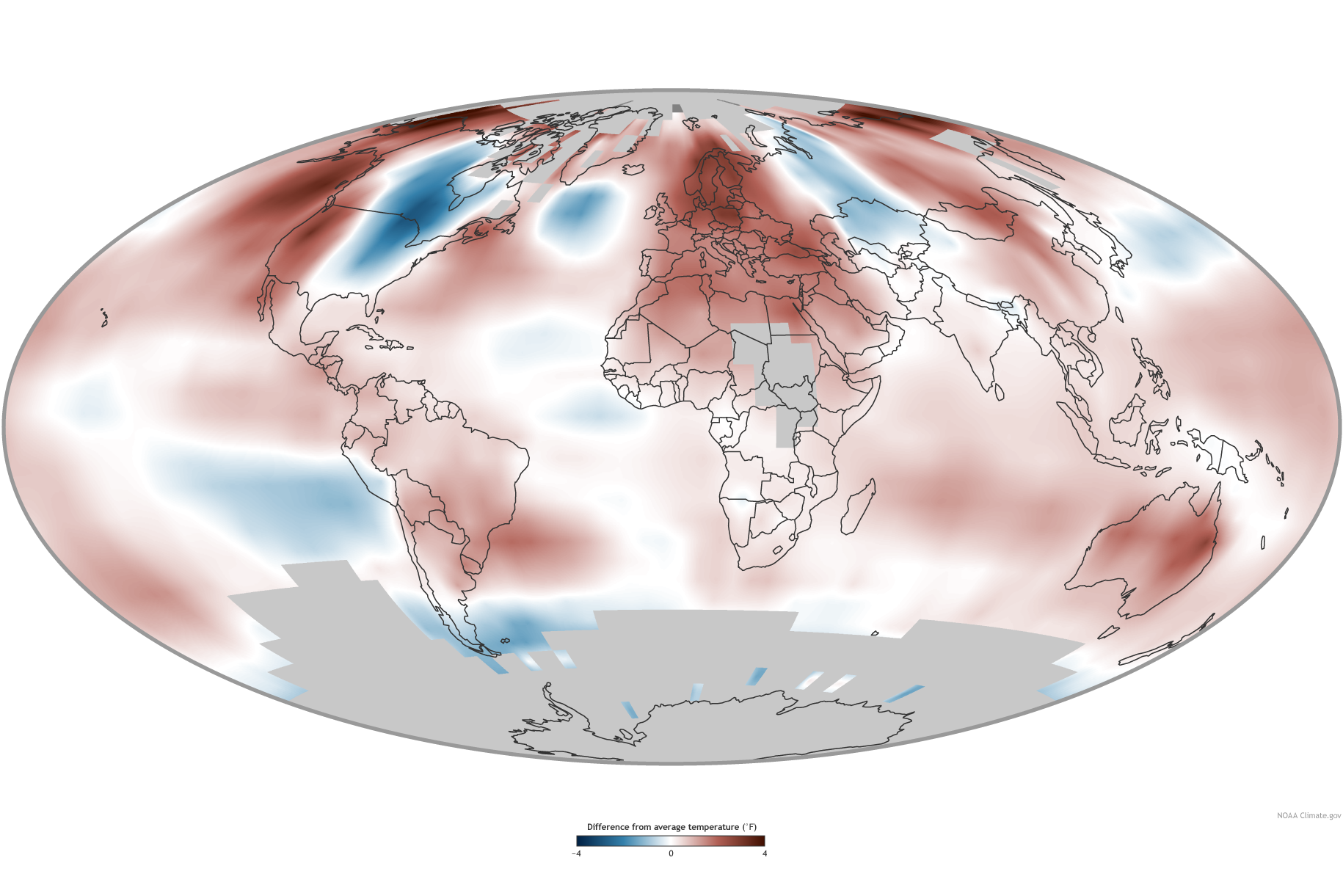
Illinois was one of the coolest places to live in 2014, at least in terms of temperature, according to the recent annual report released by the National Centers for Environmental Information (NCEI). In the map below, the areas in blue show areas where the temperatures were much colder than average for the central US and eastern Canada, while the West and Alaska were much warmer than average (areas in red).

Click to enlarge.
Temperature departures from the 1981-2010 average. Blue means colder than average while red means warmer than average. Click to enlarge.

According to the latest figures, the average temperature for Illinois in 2014 was 49.5 degrees, 2.7 degrees below the 1981-2010 average, and the 6th coolest year on record for Illinois.

Continue reading “Illinois – Coolest Place to Live in 2014?”

Historical Tornadoes in Illinois and the US

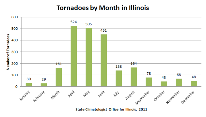
While tornadoes can happen any time of the year, the tornado season really starts to ramp up in March in Illinois (see plot below) and remains active through the spring and on into summer. April, May, and June are the three standout months historically. So far 2015 has been very quiet with no severe weather reported in Illinois so far, according to NOAA.

tornado-month

You can see more plots like this on our tornado plots page.

Historical Tornado Tracks

Continue reading “Historical Tornadoes in Illinois and the US”

February – 7th Coldest on Record for Illinois

The statewide average temperature for February was 18.6 degrees. That is 12.3 degrees below the 1981-2010 average and the 7th coldest February on record. By comparison, February 2014 was 9th coldest at 19.5 degrees.

Here are some amazing statistics for Chicago. February was tied with 1875 for the coldest on record, according to the Chicago National Weather Service.  The average temperature for February was 14.6 degrees, 13.1 degrees below average. In addition, it was the 10th coldest month overall on record. February snowfall in Chicago was the third largest on record with 26.8 inches, 17.7 inches above average.

Snowfall for February in Illinois was widespread and well above average. Amounts of 15 to 20 inches were common in western and northern Illinois and 10 to 15 across central Illinois and parts of far southern Illinois. This was 8 to 12 inches above average in many locations. See maps below. Click to enlarge.

Some other February snowfall totals from around the state:

  • Chicago Midway AP: 28.3 inches
  • Rockford: 14.7 inches
  • Peoria: 12.8 inches
  • Quincy Lock and Dam: 11.2 inches
  • Springfield: 22.6 inches
  • Champaign-Urbana: 12.4 inches
  • Bloomington-Normal: 13.0 inches
  • Carbondale: 6.0 inches

The statewide average precipitation (rain plus the water content of snow) for February was 1.5 inches, 0.5 inches below average. Most of the state received 1 to 2 inches of precipitation, except for far southern Illinois which got 2 to 3 inches. See the second batch of maps for precipitation and precipitation departures from average.

Continue reading “February – 7th Coldest on Record for Illinois”