Winter Finally Arrives in Illinois In February

February

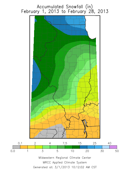
The preliminary numbers are in and winter finally arrived in February. The statewide temperature for February finished at 29.3 degrees, which was 1.5 degrees below average. The statewide precipitation was 2.7 inches, which was 0.6 inches above average. The precipitation total represented both rainfall and the water content of any snow. Snowfall for February ranged from less than an inch in southern Illinois to over 20 inches in the far northeast corner of the state.

Winter

For the core winter months of December, January, and February, the statewide temperature was 31.8 degrees, which was 2.8 degrees above average. The statewide average precipitation was 9.1 inches, 2.2 inches above average. It was the 11th wettest winter on record for Illinois. Snowfall for those three months ranged from less than 10 inches in east-central Illinois to over 20 inches in parts of far western and northern Illinois, as well as in a band across southern Illinois.

Maps

Here are the maps of precipitation and snowfall for February.

February 2013 Precipitation.

February 2013 Precipitation Departures From Average.

February 2013 Snowfall.

February 2013 Snowfall Departure.

Halfway through February – Warm and Dry in Illinois

We are halfway through February here in Illinois. The statewide average temperature through February 14 was 32.2 degrees, 6.2 degrees above normal.
The statewide average precipitation was 0.66 inches, about 86 percent of normal (first map). It has a quiet month for snowfall as well with most areas reporting 2 inches or less (second map). That’s about ten times less than the first 14 days of last February (last map).

Click to enlarge.

Click to enlarge.

Click to enlarge.

Tenth Wettest February for Illinois

The statewide average precipitation in Illinois for February was 3.39 inches, 1.46 inches above normal and the tenth wettest February since statewide records began in 1895. Precipitation includes rainfall and the water content of any snow (and freezing rain, sleet, snow pellets as was the case in February). See maps below (click to enlarge). The highest monthly precipitation total in Illinois was 7.05 inches in Paris.
Snowfall was above normal in February across much of Illinois thanks to the February 1-2 winter storm.  Snowfall totals for the month ranged from just under 4.5 inches in southeastern Illinois to over 20 inches across much of northern Illinois. The highest monthly snowfall total in Illinois was 30.5 inches in Spring Grove.
Some outstanding monthly snowfall totals include Chicago with their snowiest February on record with 29.0 inches; Rockford with their fifth snowiest February on record with 20.2 inches, Peoria with their second snowiest February on record with 20.9 inches, and Springfield with their fourth snowiest February on record with 16.5 inches.
The statewide average temperature in Illinois for February was 29.5 degrees, 0.7 degrees below normal. The highest temperature for February in Illinois was 78 degrees in Waterloo on February 21. The lowest temperature for February was -22 degrees in Elizabeth on February 10.

February 2011 precipitation.

February 2011 precipitation departure.

February 2011 snowfall.

February 2011 snowfall departure.

Cold February Wraps Up a Cold Winter

CHAMPAIGN, Ill. – Based on preliminary data in Illinois, the statewide average temperature for February 2010 was 25.1 degrees, 5.1 degrees below normal. Snowfall for February was above normal. Amounts ranged from 6 inches in southern Illinois to over 18 inches in the Quad Cities and Chicago areas.
The cold February, along with colder-than-normal temperatures in December and January, made this the 19th coldest winter on record. The 3-month average temperature was 25.3 degrees, 2.9 degrees below average. Winters in the late 1970s were still much colder with a virtual tie between the winter of 1977-1978 at 19.6 degrees and the winter of 1978-1979 at 19.9 degrees.
Winter snowfall totals (December—February) ranged from about 45 inches in northeast Illinois to just under 15 inches in southern Illinois. This was 1 to 3 inches above normal for southern Illinois to over 10 inches above normal in northern and western Illinois. Wintertime precipitation, both rainfall and the water content of snow, measured 7.04 inches and was 0.35 inches above normal.
The latest National Weather Service outlook for March calls for an increased chance of below-normal temperatures in the southern two-thirds of Illinois. It also calls for an increased chance of drier-than-normal conditions for the month. See the Climate Prediction Center page.