Outlook for Summer in Illinois – Warm, Humid, Chance of Thunderstorms

Okay, I’m just having a little fun with the headline – every summer in Illinois is warm and humid with a chance of thunderstorms. I wouldn’t have it any other way.
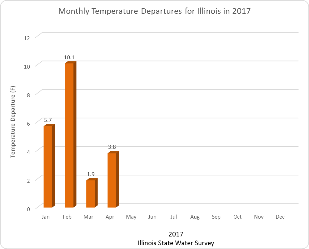
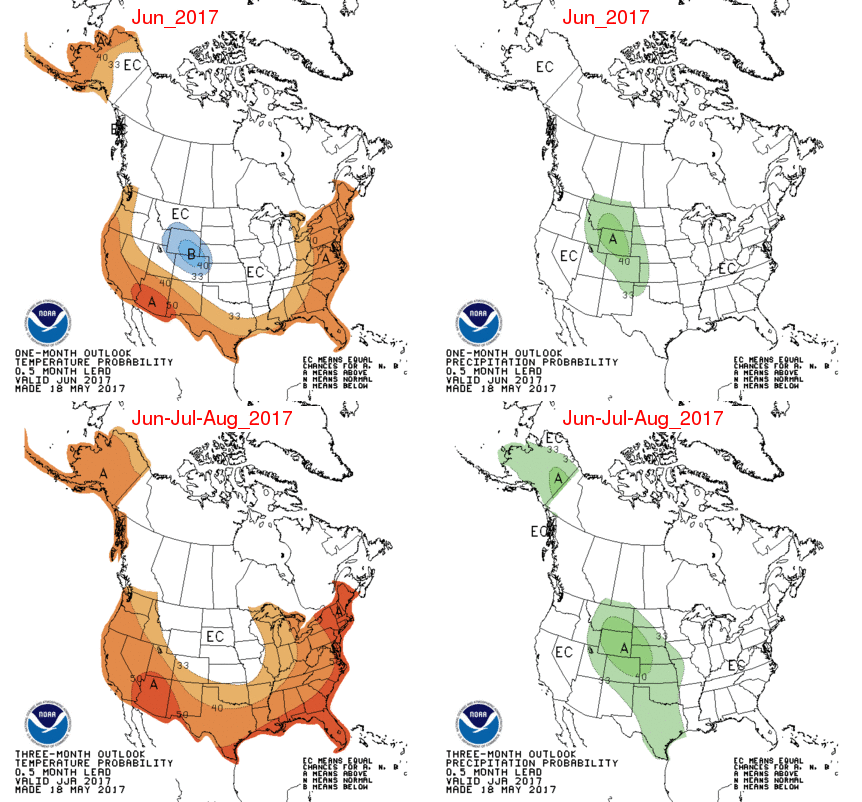
The resort to humor occurred because there was not much exciting to report from the latest NWS monthly and seasonal forecasts released yesterday. For June, Illinois has equal chances of above, below, and near-normal temperature and precipitation. For summer (June-August), Illinois has a slightly increased chance of above-normal temperatures, and equal chances on above, below, and near-normal precipitation. Or to put it another way, there are no strong indications of anything out of the ordinary for this summer.
page2

Summer Temperature and Humidity

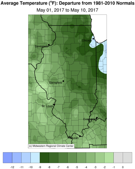
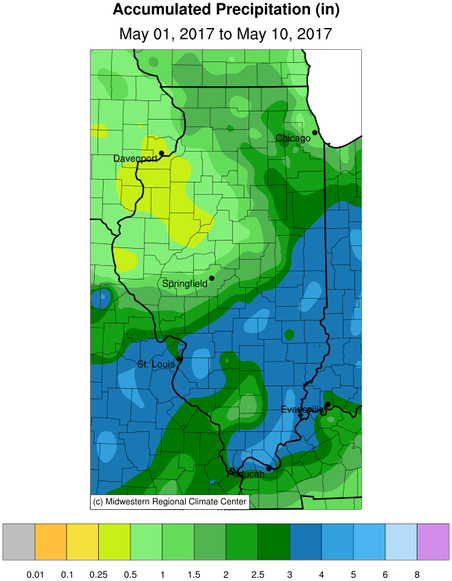
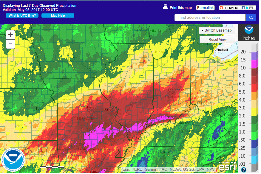
Here is how I think summer will likely play out – plenty of humidity, daytime highs near-normal, and nighttime lows above-normal. Right now we are coming off a very wet April and May, resulting in an abundance of soil moisture that will be recycled into the air this summer as higher humidity.
Continue reading “Outlook for Summer in Illinois – Warm, Humid, Chance of Thunderstorms”

Cool, Wet Start to May in Illinois

May is starting out cool across Illinois. Temperatures are running 2 to 4 degrees below normal in parts of western and southern Illinois, to over 9 degrees below normal in the Chicago area (first map). The statewide average temperature for May so far is 53.4 degrees, 5.2 degrees below normal. This comes on the heels of a very warm April.
Parts of Illinois have been wet as well. Rainfall totals of 2 to 4 inches were common in the southern half of Illinois while the northern half has been drier with many areas at 1 to 2 inches and a few areas in northwestern IL with less than an inch of rain (second map).
map2
map1
Continue reading “Cool, Wet Start to May in Illinois”

Rainfall Over the Last 2 Weeks in Illinois

 
Here are the amounts for the last week, as of this morning. The areas in purple in far southern Illinois have received between 10 and 15 inches. Areas in shades of red have received between 5 and 10 inches. The areas in orange and yellow have received between 2 and 5 inches. Areas in green in northwest IL have received between  0.5 and 2 inches.
map7
 
Here are the rainfall totals for the past two weeks. Same color scheme as before. Notice how the areas with 10 to 15 inches have expanded across much of southern IL south of Interstate 64 with a few areas just to the north.
map14
NWS Cooperative Observer Network rainfall totals in Illinois for the period of April 26 to May 5, 2017, ranked from high to low. Totals that have exceeded the expected 10-day, 100-year rainfall amounts for that area are in red. Continue reading “Rainfall Over the Last 2 Weeks in Illinois”

Wet April and 2nd Warmest January-April on Record for Illinois

Precipitation: The statewide average precipitation for April in Illinois was 7.01 inches, 3.23 inches above normal and the 2nd wettest April on record. Here are the top five wettest Aprils. Notice a pattern? Three out of the five have been since 2011.

  1. April 2011 – 7.62 inches
  2. April 2017 – 7.01 inches
  3. April 1957 – 6.99 inches
  4. April 2013 – 6.93 inches
  5. April 1927 – 6.87 inches

The largest monthly total for April in Illinois was Carbondale with 14.41 inches. Several other sites in southern Illinois had similar amounts including Bush (Williamson County) with 13.63 inches, West Frankfort (Franklin County) with 13.35 inches, Kaskaskia (Randolph County) with 13.34 inches, and Murphysboro (Jackson County) with 13.02 inches.
Temperature: The statewide average temperature for April was 56.4 degrees, 3.8 degrees above average and the 11th warmest April on record. The warmest reading for April was 89 degrees at Kaskaskia on April 20.  The coldest reading for the month was 19 degrees at Morrison on April 10.
Statewide records of temperature and precipitation go back to 1895.

Graphs

Here are the temperature departures for 2017. As you can see, every month in 2017 has been well above normal. So far this January-April is the 2nd warmest such period on record with a statewide average temperature of 43.2 degrees, 5.4 degrees above normal. Only 2012 was warmer at 44.5 degrees, 6.7 degrees above normal. [corrected from an earlier version]
image022
Continue reading “Wet April and 2nd Warmest January-April on Record for Illinois”