60th Anniversary of the First Tornado Detected by Radar

Today is the 60th anniversary of the first documented case of a tornado detected by radar. Water Survey staff, at Willard Airport in Champaign, IL, captured the historic event on film on April 9, 1953. This discovery helped lead to the first national weather radar network in the United States.
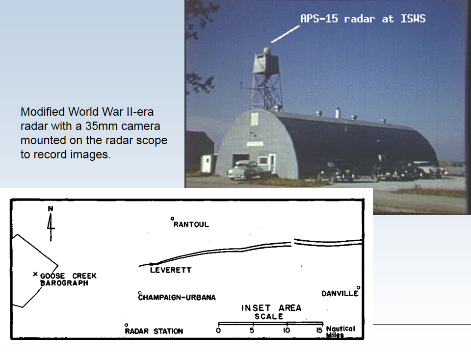
The radar was located at Willard Airport, south of Champaign IL, and was being used along with a rain gauge network to relate radar signals with rain rates. Don Staggs, the radar technician, had stayed late to complete repairs on the radar. While testing the repairs, he noticed an interesting radar return and began recording the radar scope using the mounted 35 mm camera. As a result, he captured a well-defined hook echo on film. See photo below.  The hook echo is best described by the National Severe Storm Laboratory:

“hook echo” describes a pattern in radar reflectivity images that looks like a hook extending from the radar echo, usually in the right-rear part of the storm (relative to the motion of the storm). A hook is often associated with a mesocyclone and indicates favorable conditions for tornado formation. The hook is caused by the rear flank downdraft and is the result of precipitation wrapping around the back side of the updraft.

 
Afterwords, researchers related the radar data that Don recorded to detailed damage damage reports along the tornado’s path (see map and photos below).
I find this story fascinating for a variety of reasons. Some of the reasons are personal. It happened at my home institution (Illinois State Water Survey) and I knew several of the people involved (Don Staggs, Glen Stout, Floyd Huff, Stan Changnon). But beyond that there were several key ingredients to the story:

  1. The radar was on when it should have been off. If Don Staggs had not been working late to replace a piece of equipment on the radar, the discovery would have been missed. The storm occurred in the early evening hours when the radar was normally turned off.  Don had the foresight to keep the radar running when he saw the unusual return on the radar.
  2.  The tornado occurred near one of the few radars in the country at that time designed for weather research, as opposed to defense or air traffic control. There was no network of weather radars like we enjoy today. In addition, this radar set was equipped with a 35-mm camera to record what was on the scope.
  3. The thunderstorm was strong enough to produce a clear hook echo, and was located to the north of the radar so there was no attenuation (interference) from rain.
  4. The tornado was well-documented in terms of the location and timing of the damage. This allowed scientists to relate what happened on the radar scope with what happened on the ground.

The 1954 Water Survey report on the tornado stated, “It may be possible to establish radar storm warning systems in tornado areas to reduce loss of lives.” The April 9, 1953, event, along with subsequent events, helped provide the push in the US for developing a nationwide network of weather radars.

Radar hook echo
First recorded radar hook echo that was later associated with a tornado, April 9, 1953, near Champaign, IL. Photo by Illinois State Water, Prairie Research Institute, University of Illinois. 

The radar site and track of tornado on April 9, 1953.
The radar site and track of tornado on April 9, 1953. The radar station is at the bottom of the map while the tornado passed north of Champaign-Urbana, Illinois. The radar was a highly-modified version of an airborne radar set from World War II.

Damage caused by the April 9, 1953, tornado.

Don Staggs, recounting the events of April 9, 1953, at a talk on the subject about 10 years ago.
Don Staggs, recounting the events of April 9, 1953, at a talk on the subject about 10 years ago. I have known Don for many years – he is an excellent electrical engineer and a nice guy.

Additional information on this event:

Trouble Continues on the Missouri River

The US Corps of Engineers put out a press release today on the continued problems on the Missouri River due to the drought. From the release,

Based on the current soil moisture and snowpack conditions, 2013 runoff in the Missouri River basin above Sioux City, Iowa is forecast to be 20.5 million acre feet, 81 percent of normal.  Runoff for the month of March was 55 percent of normal.

Full press release
At this time, 75 percent of the Missouri River Basin is in some stage of drought according to the US Drought Monitor. In addition 52 percent of the Upper Mississippi River Basin (above St. Louis) is in drought. See map below. Closer to home, recent rains and melted snow have kept the Mississippi River on the western boundary of Illinois in good shape this spring.

U.S. Drought Monitor.

Ten Coldest March's and What Follows

As previously reported, based on preliminary data this March in Illinois was 34.1 degrees and the 11th coldest March on record. What were the ten coldest March’s on record? I have listed them in the table below. Also I looked to see what happened in April after these chilly March’s. It turns out that half are above average and half are below average – a virtual coin toss.
The columns labeled “Depart” are the departures from the 1981-2010 statewide averages. Probably the biggest turnaround was between March 1960, which was the coldest March on record and 15.5 degrees below average, compared to April 1960 which was 2.2 degrees above average. The statewide temperature records go back to 1895. 

Rank Year March Depart April Depart
1 1960 25.6 -15.5 54.6 2.2
2 1906 30.3 -10.8 54.5 2.1
3 1912 30.4 -10.7 52.6 0.2
4 1965 31.1 -10.0 52.9 0.5
5 1984 33.0 -8.1 49.8 -2.6
6 1932 33.2 -7.9 52.1 -0.3
7 1978 33.5 -7.6 52.5 0.1
8 1989 33.5 -7.6 51.1 -1.3
9 1947 33.8 -7.3 51.0 -1.4
10 1926 34.0 -7.1 45.4 -7.0
11 2013 34.1 -7.0 ?? ??

BTW, so far this April has been cool. The first 7 days averaged 44.4 degrees statewide, and about 3 degrees below average.

March – Much Colder Than Last Year

The preliminary numbers are in – the statewide temperature for March of this year was 34.1 degrees. That is 7 degrees below the long-term average of 41.1 degrees and the 11th coldest March on record. That is in remarkable contrast to March 2012, which ended up at 55.3 degrees. That March was 14.2 degrees above the long-term average and the warmest March on record. In fact, the difference between this March and last March was a whopping 21.2 degrees.
The statewide precipitation was 2.85 inches, which is 0.15 inches below the long-term average of 3.00 inches. Precipitation amounts were largest just east of St. Louis and lightest in east-central Illinois. The largest monthly total came from Kaskaskia with 6.42 inches of precipitation. Several surrounding sites had in excess of 5 inches.
[updated 4/11/13] Snowfall was above-average for the month thanks mostly to a large storm that passed through central Illinois on March 24-25 and some earlier events that passed through northern and western Illinois. The Springfield COOP site received 17 inches in 24 hours, a new 24-hour record for that site, and a storm total of 18.5 inches. They finished the month with 19.6 inches of snow. The CoCoRaHS site at Nokomis (IL-MY-1), to the south of Springfield, had a similar experience with 19 inches of snow from the one storm and a monthly total that tied Springfield with 19.6 inches. A CoCoRaHS site at Springfield (IL-SG-17) reported 18 inches during the one storm and a monthly total of 19.5 inches.
Precipitation totals and departures from the long-term average for March:

Click to enlarge.
Click to enlarge.

Click to enlarge.
Click to enlarge.

Snowfall totals and departures from the long-term average for March:
Click to enlarge.
Click to enlarge.

Click to enlarge.
Click to enlarge.