The wetter and warmer than normal weather continued in Illinois this week. For the period of June 16-22, the state average temperature was 76.8 degrees, 3.6 degrees above normal. Meanwhile the statewide average precipitation was 2.46 inches, 1.55 inches above normal.
Illinois already experienced above normal temperature and precipitation in the first half of June. Combined with this week’s weather, the statewide average temperature for June so far is 74.5 degrees, 3.4 degrees above normal. The statewide average precipitation at this point is 6.35 inches, 3.37 inches above normal.
If you are thinking that we must be closing in on a record, you are correct. Statewide this is already the 10th wettest June on record. The wettest June on record is 1902 with 8.37 inches. Several individual station records will be set as well. For example, Galesburg has already received 11.25 inches this month. This handily beat the old June record of 9.97 inches set in 1974. This is impressive given that their records go back to 1927.
The wettest areas of the state are western Illinois and east-central Illinois. Based on radar estimates and reports from weather observers, monthly totals of 9 inches or more were common in these areas. The wettest spot so far is Warsaw (Hancock County CoCoRaHS observer) which has reported 11.38 inches through today (June 22) with more rain falling after the regular reporting time.
Here are the precipitation and precipitation departure maps for June 1-22, 2010, for Illinois.


First Half of June – Warm and Wet
Based on preliminary data, the statewide average temperature for the first half of June was 73.4 degrees, 3.3 degrees above normal.
The statewide average rainfall for the first half of June was 3.85 inches, 1.78 inches above normal. Much of the southern and northern thirds of the state were near normal while central Illinois was much above normal.
The wettest areas are in a region between Quincy and the Quad Cities (again) and in east-central Illinois. For June 1-15, the following rainfall totals were reported: Moline with 4.35 inches, Quincy with 4.78 inches, Springfield with 3.85 inches, Champaign with 4.88 inches , and a CoCoRaHS observer in Sidney (SE of Champaign) with 7.84 inches.
The National Weather Service provides a high-resolution precipitation product that combines both rain gauge and radar data. It can be found at http://water.weather.gov/precip/. Here is the rainfall departure map for June 1-15, 2010, clearly showing the heavy rain areas in western and east-central Illinois.
More rains are falling in Illinois while this is being written on the afternoon of June 15.

Warmer Conditions Prevail in Late May
After a cold start to May (see earlier post), the period between May 18 and 27 was much warmer. The statewide average temperature during this period was 3.7 degrees above normal. The earlier cold period and this later warm period will pretty much cancel out, leaving May temperatures close to normal as we near the end of the month.
The statewide rainfall for the month is at 5.48 inches, 1.71 inches above normal. While wetter than normal, this is a long ways from the record May rainfall for Illinois of 8.87 inches set in 1943.
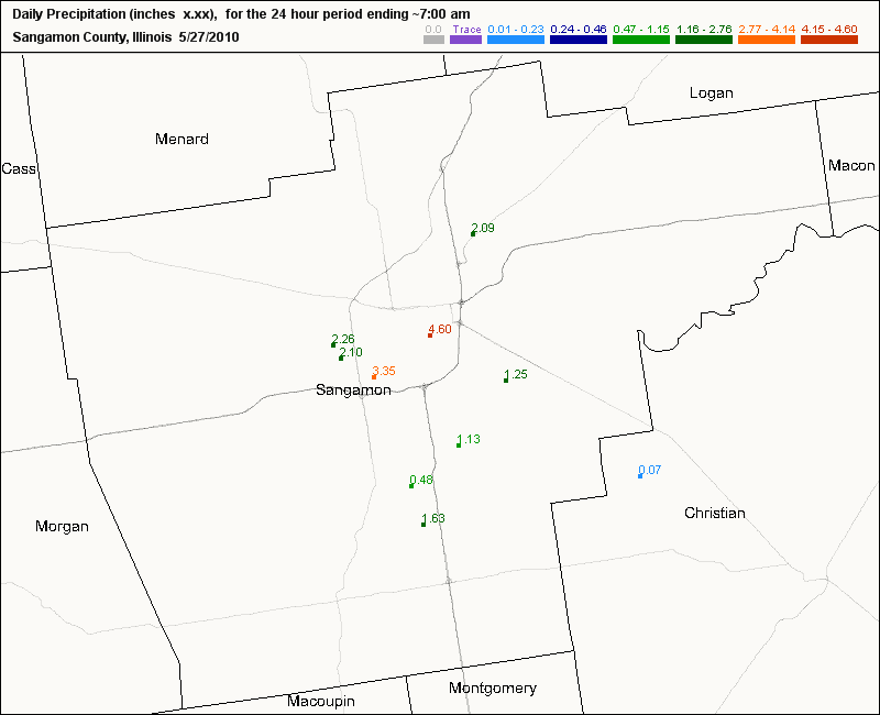
On a personal note, I drove through Springfield on I-72 on the afternoon of May 26 when a severe thunderstorm developed over the city. According to CoCoRaHS weather observers in Springfield, rainfall reports ranged from 2.10 on the far west side to 4.60 inches in the east-central side of the city – all in less than 2 hours (see map). I drove through wind-driven rain, lightning, and pea-sized hail. The flooding along the I-72 and I-55 entrance and exit ramps was impressive but conditions were even worse in town.

Impact of Wet Fields on Corn
Emerson Nafziger, University of Illinois agronomist, posted an interesting article about the impact of wet fields on newly planted corn. The article appears in the current issue of The Bulletin, published by the College of Agricultural, Consumer, and Environmental Sciences (ACES). The article starts out about frost damage but halfway down Emerson addresses the potential damage of all the heavy rains.
A larger concern after heavy rainfall in parts of Illinois this week will be standing water and, for the crop recently planted, the possibility of emergence problems. There were a few reports of death of germinating seeds in fields planted a few days before heavy rain in parts of western and southwestern Illinois, but this is not widespread. We think that such seeds simply ran out of oxygen and that shoots died before emergence. Seedlings that have emerged and have roots are more resilient, but there is a very good chance that plants that stand in water for more than two or three days will not survive, especially if temperatures go up. Higher temperatures mean less oxygen in the water and also faster seedling metabolism rates, so plants run out of oxygen sooner.
Even if plants survive, their regrowth can be slow due to poor conditions around the roots. Diseases can also invade plants that stand in water; one example is the downy mildew fungus that can carry crazy-top, whose symptoms won’t appear for weeks after the water is gone. In any case, we often see plant size and health diminish as we move from the edge to the middle of low areas where water stood. If the size of the drowned-out area is large enough to justify a repair-planting after it dries up, it might be a good idea to plant into the area around the edge with living but slow-growing plants as well, in order to replace sickly plants with healthy ones.
In an earlier post, I noted that areas in western and northern Illinois were exceptionally wet in the first half of May. The latest NASS report for Illinois shows that as of May 16, 56 percent of the state had topsoil moisture rated as surplus.

