A Weak El Nino Has Arrived, Another Winter Storm for Southern Illinois

1680v1_20150305-ElNino_arrives_1200
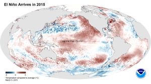
El Niño Arrives in 2015. This image shows the average sea surface temperature for February 2015 as measured by NOAA satellites. The large area of red (warmer than average) can be seen extending through the equatorial Pacific. (Credit: NOAA)

Today the National Weather Service reported that the long-awaited El Niño has arrived in the Pacific Ocean. El Niño occurs when we have above-average temperatures in the Pacific Ocean along the equator. It alters the Pacific weather pattern, which in turn alters our weather patterns over the US. The NWS forecasters say “it is likely (50 to 60 percent chance) that El Niño conditions will continue through summer. ” Due to the weak nature of this event, they are not expecting widespread or strong impacts from this event.

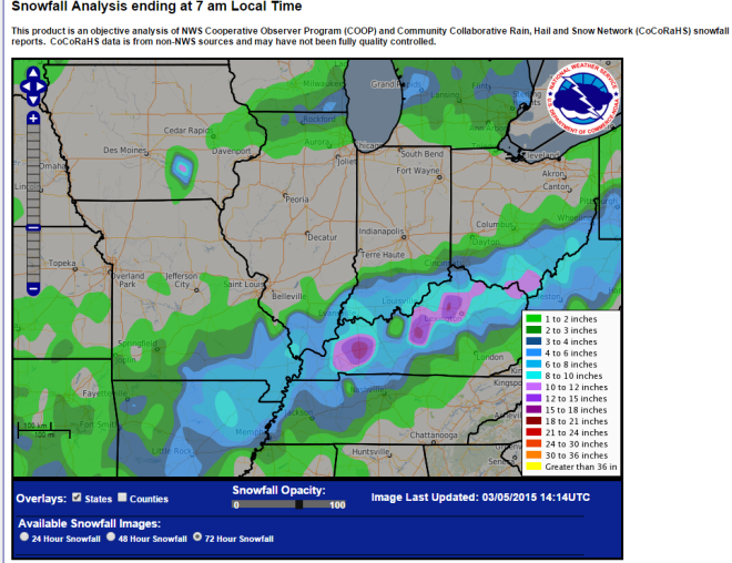
In other news, far southern Illinois was hit this week with another winter storm that passed through Arkansas; southeastern Missouri;  southern Illinois, Indiana, and Ohio; as well as most of Kentucky and points beyond. Some of the largest snowfall totals from this event include Grand Chain Dam with 10.0 inches and Brookport Dam with 9.0 inches.
snow-south

Latest Outlook for Winter in the US

Today the NOAA Climate Prediction Center released their latest winter forecast. First, there are two important notes about the winter forecast. One is that El Niño has not arrived yet, and if it does, it is expected to be mild.

The other point is that the current conditions are not always a reliable predictor of future conditions. In other words, just because we are having a cold November (9 degrees below average), that does not doom us to another cold winter. To give a recent example, November of 2012 was 1.3 degrees below average, while the following winter of 2012-13 was 3.0 degrees above average.

The first panel shows the temperature odds for December-February, our core winter months. Southern Illinois has a slightly elevated chance of colder-than-average temperatures as does most of the southern states. There is a stronger chance that temperatures will be above-average on the West Coast and Alaska.

DecJanFeb_temp_outlooks_with_pies_610

The second panel shows the precipitation odds for winter. The outstanding feature for us is the large area around the Great Lakes with an increased chance of being drier-than-average that covers all of Illinois.

DecJanFeb_precip_outlooks_with_pies_610

El Nino and the Midwest

NOAA has released a new 2-page fact sheet on El Niño and the Midwest (links below). Several people in the Midwest had input into this, including myself. El Niño typically results in warmer and drier than average winters. Confidence in these patterns is higher during stronger El Niño events.

Right now the NOAA Climate Prediction Center states that El Niño is favored to begin in the next 1-2 months and last into spring of 2015. The current thinking is that the odds are 2-in-3 in favor of it arriving and that the event will likely remain weak throughout its duration.

PDF version: EN-MW-Sep2014

Online version:

[scribd id=242836832 key=key-2ql4MIpJSjgpfv25L5Zd mode=scroll]

Weather Outlook for Fall and Winter in Illinois

The NOAA Climate Prediction Center released their monthly outlook for September and 3-month outlooks for September and beyond. At this time, they are not expecting a repeat of last winter for Illinois.

According to them, the chance of El Niño has decreased to about 65% during the Northern Hemisphere fall and early winter. If it does show up, it is expected to a moderate to weak event. As a result, the impacts on the US and the Midwest will likely be modest at best.

September and FALL

For both September and this fall, there is an equal chance (EC) of above, below, near-average temperature and precipitation (4-panel figure below) for Illinois. The north-central US is not expected to have below-average temperatures, like it has experienced this summer. This may give crops in those areas a better chance of reaching maturity this fall.

It does look like temperatures are expected to stay above-average on the West and East Coast, as well as Alaska. Wetter-than-average conditions are expected to prevail in the southwest US, and expand into the Plains and parts of Iowa and Missouri later in the fall.


page2


WINTER (December-February)

For Illinois, the current forecast is for equal chances of above, below, and near-average temperatures. Or to put it another way, they see no sign of a repeat of last winter. And they are expecting below-average precipitation in Illinois and across the Great Lakes region. It is still early in the year to lock in on this forecast so I would not cancel orders for snow blowers or salt deliveries just yet.

off04_tempoff04_prcp