2011: A Year of Extremes

I think we will remember 2011 as a year of extreme events. In Illinois we have already faced a February blizzard, flooding, record rainfalls, drought, and a heat wave.  The latest newsletter of the NOAA’s Regional Climate Centers Program has highlighted several major events from around the country, including:

  • wildfires
  • tornadoes
  • spring flooding in the Midwest
  • record flooding in the Missouri River Basin
  • drought
  • snow

Check it out. I don’t know about anyone else but I’m ready for a quiet fall.
BTW, the Midwestern Regional Climate Center is housed at the Illinois State Water Survey.
Late Season Snowfall in Chicago and Rockford

Gino Izzi of the NWS office in Romeoville rounded up these statistics for late season snowfall in Chicago and Rockford…

PUBLIC INFORMATION STATEMENT
NATIONAL WEATHER SERVICE CHICAGO IL
1128 AM CDT FRI MAR 25 2011 /1228 PM EDT FRI MAR 25 2011/
...LATE SEASON SNOWFALLS...
NOTHING SAYS SPRING TIME IN ILLINOIS MORE THAN TEMPERATURES IN THE
20S AND GRAY CLOUDY SKIES...BUT HISTORICALLY SPEAKING IT MAY BE A
BIT TOO SOON TO STOW AWAY THOSE SHOVELS. IN FACT...PORTIONS OF
MISSOURI AND DOWNSTATE ILLINOIS ARE SEEING SNOW THIS MORNING. SO
HOW COMMON IS IT TO SEE SHOVEL-ABLE SNOW IN OUR AREA THIS TIME OF
YEAR?
IN CHICAGO...54 OF THE PAST 139 YEARS (OR ABOUT 39%) HAVE HAD AT
LEAST ONE DAY WITH AN INCH OR MORE OF SNOWFALL ON OR AFTER MARCH
25TH. IN FACT...17 OF THOSE YEARS HAD MULTIPLE DAYS WITH OVER AN
INCH OF SNOWFALL INCLUDING 6 DAYS WITH OVER AN INCH OF SNOW BACK IN
1926! HERE ARE SOME OF THE RECENT LATE SEASON (AFTER MARCH 25TH)
CHICAGO SNOWFALLS...
SNOWFALL    DATE
 3.0     4/11/2007
 3.0     4/ 7/2003
 2.1     4/ 5/2009
 1.9     3/27/2008
 1.6     4/ 7/2000
 1.2     3/29/2009
HERE ARE THE TOP 10 BIGGEST LATE SEASON SINGLE DAY SNOWFALL TOTALS
FOR CHICAGO...
RANK   SNOW      DATE
 1    13.6    3/25/1930
 2     9.4    4/ 5/1982
 9.4    4/ 2/1975
 4     9.0    4/ 6/1938
 5     8.9    3/26/1970
 6     8.2    4/ 1/1970
 7     7.8    3/30/1926
 8     7.7    3/29/1954
 9     7.1    3/29/1964
10     6.6    3/26/1934
IN ROCKFORD...47 OF THE PAST 118 YEARS (OR ABOUT 40%) HAVE HAD DAYS
WITH AN INCH OR MORE OF SNOWFALL ON OR AFTER MARCH 25TH. OF THOSE
YEARS...10 HAVE HAD MULTIPLE DAYS WITH OVER AN INCH OF SNOW
INCLUDING 4 DAYS IN 1970 AND 1926. HERE ARE SOME RECENT LATE SEASON
ROCKFORD SNOWFALLS...
SNOWFALL    DATE
 1.9     4/11/2007
 1.8     3/29/2009
 1.2     4/ 7/2000
 1.1     4/ 1/2002
 1.0     4/12/2007
HERE ARE THE TOP 10 BIGGEST LATE SEASON SINGLE DAY SNOWFALL TOTALS
FOR ROCKFORD...
RANK   SNOW      DATE
 1    13.5    3/31/1926
 2    10.4    3/29/1972
 3     7.0    4/18/1912
 4     6.3    4/ 5/1982
 5     6.0    4/ 6/1938,  6.0    3/25/1933
 7     5.0    3/29/1954
 8     4.8    3/29/1964
 9     4.6    4/ 2/1975
10     4.5    4/ 2/1936,  4.5    3/28/1894
WHILE NO BIG SNOWS ARE CURRENTLY IN THE FORECAST FOR THE REGION...IT
IS WORTH NOTING THAT LATE SEASON SNOWS ARE NOTORIOUSLY DIFFICULT TO
PREDICT MUCH IN ADVANCE. CURRENT INDICATIONS ARE THAT THE COLD AIR
OVER THE AREA NOW WILL REMAIN IN PLACE THROUGH THE WEEKEND INTO
EARLY NEXT WEEK.
$$
IZZI

Tenth Wettest February for Illinois

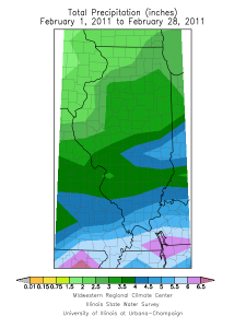
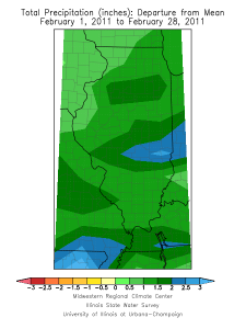
The statewide average precipitation in Illinois for February was 3.39 inches, 1.46 inches above normal and the tenth wettest February since statewide records began in 1895. Precipitation includes rainfall and the water content of any snow (and freezing rain, sleet, snow pellets as was the case in February). See maps below (click to enlarge). The highest monthly precipitation total in Illinois was 7.05 inches in Paris.
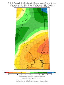
Snowfall was above normal in February across much of Illinois thanks to the February 1-2 winter storm.  Snowfall totals for the month ranged from just under 4.5 inches in southeastern Illinois to over 20 inches across much of northern Illinois. The highest monthly snowfall total in Illinois was 30.5 inches in Spring Grove.
Some outstanding monthly snowfall totals include Chicago with their snowiest February on record with 29.0 inches; Rockford with their fifth snowiest February on record with 20.2 inches, Peoria with their second snowiest February on record with 20.9 inches, and Springfield with their fourth snowiest February on record with 16.5 inches.
The statewide average temperature in Illinois for February was 29.5 degrees, 0.7 degrees below normal. The highest temperature for February in Illinois was 78 degrees in Waterloo on February 21. The lowest temperature for February was -22 degrees in Elizabeth on February 10.

February 2011 precipitation.

February 2011 precipitation departure.

February 2011 snowfall.

February 2011 snowfall departure.

Snowy Winter in Illinois

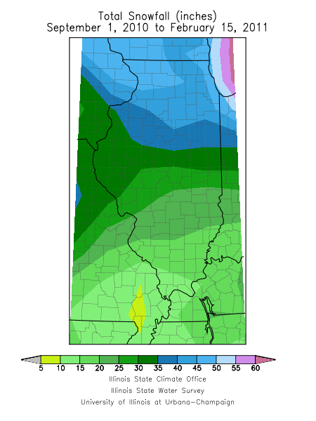
Does it seem like this has been an unusually snowy winter in Illinois? The answer is yes. We are halfway through February and the snowfall totals for this winter are already impressive. Amounts range from about 10 to 20 inches in southern Illinois, 15 to 35 inches across central Illinois, and 35 to  over 50 inches in northern Illinois. See first map.
The second map shows the snowfall departure from normal for the period ending on February 15. Essentially all of Illinois has experienced above normal snowfall so far in the season. The southern half of the state is about 4 to 12 inches above normal. Meanwhile, the northern half of the state is about 12 to 24 inches above normal.

Total snowfall through February 15.
Total snowfall through February 15 for the 2010-2011 season in Illinois.

Snowfall departure for Illinois
Snowfall departures for Illinois through February 15, 2011.