Staying Ahead of Intense Precipitation in Illinois

The Prairie State is no stranger to intense precipitation and consequential flooding. However, the frequency and intensity of rainfall have been increasing in recent decades, putting a renewed focus on the information, warning systems, planning and preparation needed to protect Illinois from the threat of intense rainfall.

Intense Rainfall Background

The philosopher Luke Bryan argued, “rain is a good thing.” However, rainfall is much like Oreos, such that problems arise when there is too much of a good thing. Intense precipitation — generally defined as surplus rain that falls in a relatively short period of time — is known to cause significant problems, the most common of which is flooding. Intense rainfall has a higher risk of causing flooding, especially flash flooding and urban or “pluvial” flooding because of more runoff. When rain reaches the ground, it will either move or infiltrate into the soil, stay on the surface (e.g., ponding, etc.) or runoff on the surface. The last of these, runoff, increases substantially as rainfall intensity increases (Figure 1).

Figure 1. Rainfall infiltration, surface detention, and surface runoff with varying rainfall intensity. The plots show the spike in runoff with higher precipitation intensity over a relatively short period of time. Figure source: Guo et al. 2019.

Impacts of Intense Rainfall

When we have a very intense rainfall event, runoff increases and can overwhelm stormwater drainage systems, natural and human-made drainage ditches, and cause flooding in and out of known flood zones. We have seen recent examples of localized intense rainfall that caused flooding in both rural areas and urban areas of Illinois, including the 2021 Gibson City storm and 2023 flash flood events in the Chicagoland area. Flooding remains the costliest weather-related hazard across Illinois. In fact, flooding in urban areas caused at least $2.4 billion in documented damages in Illinois between 2007 and 2014 (Winters et al. 2015). The July 2023 Chicago flooding event alone caused an estimated $500 million in flood damages (Lincoln, 2024).

Increased runoff from more intense precipitation can cause other impacts besides flooding, including excess nutrient runoff, soil erosion and sedimentation, and water contamination. Nutrient runoff from agriculture and municipal and industrial sewage or wastewater treatment facilities has been a water quality problem in Illinois for decades. The most recent Illinois Nutrient Loss Reduction Strategy Biennial Report showed both nitrate-nitrogen and total phosphorous loads increased in Illinois waterways in the period 2017-2021 relative to the 1980-1996 baseline (Illinois EPA, 2023). These increases were partly attributed to greater runoff associated with more frequent intense rainfall across the state.

Intense rainfall and corresponding higher runoff and flooding risk can also cause significant personal and public health impacts (Figure 2). According to the Illinois BRACE program, flooding in the state from intense rainfall is linked to injuries and deaths as well as contamination of potable water from sewage overflow, and disruptions to drinking water availability.

Figure 2. Intense precipitation impacts on public and personal health across urban and rural areas. The figure is adopted from the U.S. government’s Climate Toolkit.

The health impacts from intense rainfall and flooding disproportionately impact residents in flood-prone areas as well as the elderly, children, and low-income communities in both urban and rural parts of the state. Sewage overflows and corresponding health impacts are chronic issues that are made worse by intense rainfall in several parts of the state, such as has been seen in Chicago and southern Illinois.

Prediction of Intense Precipitation is Tricky

Many intense rainfall events are produced by strong convective storms and often impact a relatively small area such as one or multiple counties. In some cases, a storm will produce devastating intense precipitation in one neighborhood of a city and little to no rainfall in another neighborhood. Figure 3 shows an example of these large gradients in rainfall from the July 2024 intense precipitation and flash flooding event in the Rockford area. Most of the central part of the city of Rockford was inundated with 4-6 inches of precipitation overnight on July 13-14, 2024, but areas just 10 miles north or south of downtown Rockford only had around 1 inch over the same period. 

Figure 3. One-day rainfall ending at 7 a.m. local time on July 14, 2024, around Rockford. The map was produced by the National Weather Service Chicago Office. More details on this storm and flash flooding event are available in a National Weather Service report.

In addition to producing very large precipitation gradients across very small distances, these storms can form, evolve, and die within hours. These characteristics make it very challenging to forecast the exact timing, location, and magnitude of the heaviest rainfall. In many cases, National Weather Service offices will issue excessive precipitation advisories or flood statements if intense rain is expected. However, forecasters may only be able to provide warnings of potentially devastating or life-threatening intense rainfall and flooding minutes ahead of time. Advances in weather forecasting and communication have greatly reduced flood vulnerability across Illinois in recent decades. However, as recent events in our state and in other places have shown, more work is needed to both accurately forecast and effectively communicate intense rainfall risk.

Intense Precipitation in a Changing Climate

The most recent National Climate Assessment showed that the most intense rainfall events have increased by 45% in the Midwest over the past several decades (Marvel et al. 2023). Here in Illinois, the observed number of extreme precipitation events has increased by around 40% since the early 1900s (Wuebbles et al. 2021; Figure 4). These changes are primarily driven by human-caused climate warming and are largely projected to continue through the 21st century without further greenhouse gas emissions abatement (Wuebbles et al. 2021; Wilson et al. 2023).

Figure 4. The number of extreme precipitation days — those with 2 or more inches of rain — across Illinois between 1900 and 2018. The values are averaged for five-year periods. Dots show annual values and the horizontal black line shows the long-term annual average frequency of extreme precipitation events.

The recent and likely near-future increase in the frequency of intense precipitation requires further efforts to make communities, businesses, ecosystems, and people resilient to this hazard and resulting flooding and other impacts. Fortunately, many solutions and strategies are effective for mitigating impacts from intense rainfall and flooding. Individuals can consider water conservation practices including using rain barrels that help reduce stormwater surges, as well as converting portions of lawn to naturalized areas that are able to absorb more water, such as rain gardens. Landowners and land managers should consider the development and restoration of wetlands, floodplain reconnection, and stream restoration as potential strategies for reducing flooding issues. Farmers and agriculture land owners can further soil and water conservation practices, including extended crop rotation, winter field cover, and conservation-minded tillage and input practices. Municipalities and local governments can explore community-centered water infrastructure upgrades, flood-ready development, and policy incentives for flood resilience.

Keeping Track of Intense Rainfall

At a very basic level, we are only able to plan for, respond to, and mitigate intense precipitation impacts if we understand their risk across Illinois. Assessing risk requires high quality, continuous, and long-running measurements of precipitation across the state. For well over a century, the National Weather Service has coordinated daily precipitation measurements at many locations across the state through the Cooperative Observer Program (COOP). These precipitation observations, going back to the late 1800s in some places, are taken by citizen volunteers, and they are the backbone of understanding the risk of intense precipitation and how that risk has changed over the past 100-plus years. Figure 5 shows the annual maximum one-day rainfall at four places with weather records that stretch back to at least 1895. Unfortunately, Illinois — as with many states — has struggled to keep COOP stations running over the last few decades. The data and information these stations and their citizen volunteers provide are invaluable for assessing and reducing the risk of intense precipitation, and COOP should therefore be supported to continue its successful role in rainfall and flood protection.

Figure 5. Time series of annual maximum one-day precipitation from Mount Carroll, Normal, Du Quoin, and Olney between 1895 and 2025. Each of these long-running stations is part of the important National Weather Service COOP program.

One of the limitations of COOP is that it largely provides daily summary weather information, including one-day precipitation totals and maximum and minimum temperature. The most impactful intense rainfall events, though, often do not span an entire day or multiple days, but may only last for a few hours. Measuring precipitation at sub-daily, and even sub-hourly, intervals is important for understanding and predicting the dynamics and mechanisms that create intense precipitation. The Illinois Climate Network, part of the Illinois State Water Survey’s Water and Atmospheric Resources Monitoring Program helps to fill this gap of sub-daily precipitation observations. The network operates 20 stations across Illinois, each observing many weather variables at very fine time intervals, in some cases every one to five minutes. These high frequency measurements help scientists and emergency managers study, understand, predict, and plan for intense precipitation. For example, the station near Brownstown in Fayette County observed a very intense precipitation event overnight on July 20-21, 2025. The station recorded a total of around 5 inches of rainfall in a short period of time; however, nearby stations picked up closer to 10-12 inches. The Illinois Climate Network station was able to measure precipitation over the course of the storm at five-minute intervals, shown in Figure 6a.

Figure 6a. Five-minute rainfall measurements at the Illinois Climate Network site near Brownstown during the July 20-21 intense rain event.

The high frequency measurements allow us to see that well over 0.50 of rain fell in just five minutes between 10 and 11 p.m. on July 20. This means that while the average rainfall intensity of this storm — as measured by the Illinois Climate Network station — was around 0.50-0.75 inches per hour, the peak five-minute intensity was closer to 12 inches per hour.

Figure 6b. Maximum amount of precipitation measured during that event at Brownstown for different time periods ranging from five minutes to 90 minutes.

These high frequency observations also allow us to see that nearly 2.5 inches fell in just 30 minutes in this storm, which is incredibly intense. Just like the COOP station measurements, it is important that we continue to support high impact weather measurements through the Illinois Climate Network for flood and other hazard protection.

Making Sense of Rainfall Information: Design for Storms

A perfect weather prediction is of no value if it cannot or does not inform better decision making to reduce impacts. Therefore, we need to use the rain measurements from our weather stations to inform decision making such as for engineering infrastructure, flood mapping, and warning systems. One specific case is the use of intense precipitation measurements to inform the design of water infrastructure like reservoirs and storage ponds, culverts, and storm drains. This process, known as design rainfall, estimates the total amount of precipitation with a certain probability of occurrence over a given time. For example, locations in northeast Illinois have a 1% chance of getting at least 8.25 inches in 24-hours, according to the Illinois State Water Survey’s Bulletin 75 (Angel et al. 2020). These estimates help engineers and planners properly design infrastructure and other development to minimize flooding and inundation risk caused by intense rainfall. There have been many updates to design storm estimates in Illinois and the broader United States over the past several decades. Table 1 shows the 1% annual exceedance probability — also informally known as a 100-year storm — estimate for 24-hour rainfall in northeast Illinois, and how that estimate has changed over the decades. The publication year is listed next to each source.

Table 1. Design storm rainfall total estimates for northeast Illinois, showing 1% annual exceedance probability storm totals for a 24-hour period and a 72-hour period. The table shows rainfall estimates from various sources published in the past 60 years.

It is evident that the 1% annual exceedance probability in northeast Illinois has increased over the years, from 6.46 inches in Technical Paper 40, published in 1961, to 8.25 inches in Bulletin 75, published in 2020. This increase in design storm rainfall illustrates the challenges of building and development in a changing climate. For example, if a city built a storage pond or culvert for a subdivision in the 1960s and sized it for the 1% annual exceedance probability at that time, that same infrastructure would likely be undersized for the risk of intense precipitation in our current climate. It is therefore critical that we not only continue and expand precipitation measurements, but also regularly update design storm estimates to ensure our development and infrastructure is resilient to our current climate. The National Oceanic and Atmospheric Administration is currently updating design storm estimates nationwide in the forthcoming Atlas 15.

The last row of Table 1 shows design storm estimates from the Illinois State Water Survey’s Bulletin 76, which was published in 2025. The reference in the table to 2050 is because Bulletin 76, for the first time in state history, uses future rainfall information from projections and not historical rainfall information to estimate design storms. Bulletin 76 was undertaken by the Illinois State Water Survey in response to strong demand from water managers, engineers, and decision makers who wanted to know how much intense precipitation is expected to increase by mid-century. This information is very important to properly design and engineer infrastructure that will, hopefully, last well beyond 2050. 

Making Sense of Rainfall Information: Flood Modeling & Mapping

Forecasting and measuring rainfall totals alone does not properly communicate flood risk, because different places are at higher or lower risk of flooding due to their soils, topography, proximity to large bodies of water, and many other factors. Flood modeling and mapping techniques use rainfall information to better understand and predict flooding, which can better prepare communities and reduce the risk of flood impacts. The Coordinated Hazard Assessment and Mapping Program at the Illinois State Water Survey maps and models flood risk across Illinois, assesses flood zones and overall flood risk, and works with communities to reduce flood risk. One example of the intersection between intense precipitation data and flood forecasting is from the intense rainfall event in southern Illinois in April 2025. Figure 7 shows the 72-hour total precipitation that fell across southern Illinois during this event and the annual exceedance probability of those totals. The storm produced exceptionally heavy rain across much of southern Illinois, including 72-hour totals that exceeded 9 inches in part or most of Jefferson, Marion, Alexander, and Pulaski counties. The intense precipitation in these areas exceeded a 1% annual exceedance probability, or 100-year storm, in Jefferson and Marion counties and exceeded a 0.2% annual exceedance probability, or 500-year storm, in Alexander and Pulaski counties.

Figure 7. Maps of 72-hour precipitation and 72-hour annual exceedance probabilities from the April 2025 storm in southern Illinois.

The Coordinated Hazard Assessment and Mapping Program group used their modeling and mapping techniques to estimate potential inundation and damages across the flooded areas. These modeling and mapping efforts provide critical information that the state, counties, and local decision makers can use to assess and reduce flood risk from intense precipitation like the April event in southern Illinois.

Summary

Intense rainfall causes significant problems in Illinois, from flooding to water quality and public health. Climate change is making intense rainfall more frequent across our state. It is therefore critically important that we measure and monitor these extreme events and use this information to make better flood mapping and modeling that can inform better decisions to reduce flood risk for all Illinoisans.

Sources

Baker, J.M., Wilson, A.B., Ainsworth, E.A., Andresen, J., Austin, J.A., Dukes, J.S., Gibbons, E., Hoppe, B.O., Ledee, O.E., Noel, J., Roop, H.A., Smith, S.A., Todey, D.P., Wolf, R., Wood, J.D. 2023. Midwest. In: Fifth National Climate Assessment. Crimmins, A.R., C.W. Avery, D.R. Easterling, K.E. Kunkel, B.C. Stewart, and T.K. Maycock, Eds. U.S. Global Change Research Program, Washington, DC, USA. https://doi.org/10.7930/NCA5.2023.CH24, available online at: https://repository.library.noaa.gov/view/noaa/61592.

Crimmins, A.R. (editor), Avery, C.W. (editor), Easterling, D.R., Kunkel, K.E. (editor), Stewart, B.C. (editor), and Maycock, T.K. (editor), 2023: Fifth National Climate Assessment, U.S. Global Change Research Program. United States. National Environmental Satellite, Data, and Information, DOI : https://doi.org/10.7930/NCA5.2023, available online at: https://repository.library.noaa.gov/view/noaa/61592.

Illinois Nutrient Loss Reduction Strategy Biennial Report 2021-22, 2023: Illinois Environmental Protection Agency and Illinois Department of Agriculture; Springfield, Illinois. University of Illinois Extension; Urbana-Champaign, Illinois. https://epa.illinois.gov/topics/water-quality/watershed-management/excess-nutrients/nutrient-loss-reduction-strategy.html.

Lincoln, W.S., and Ford, T.W., 2024: An Analysis of Extreme Rainfall Events in Chicago and Vicinity Since 1950. National Weather Service Central Region Technical Service Publication 21, https://www.weather.gov/media/crh/publications/TSP/TSP-21.pdf.

Winters, B.A., and coauthors, 2015: Report for the Urban Flooding Awareness Act, Illinois Department of Natural Resources, State of Illinois, https://dnr.illinois.gov/content/dam/soi/en/web/dnr/waterresources/documents/final-ufaa-report.pdf. Wuebbles, D., J. Angel, K. Petersen, and A.M. Lemke, (Eds.), 2021: An Assessment of the Impacts of Climate Change in Illinois. The Nature Conservancy, Illinois, USA. https://doi.org/10.13012/B2IDB-1260194_V1

Flooding – Deadly Risk in Illinois with 28 Deaths in 19 Years

Right now the attention is on the widespread flooding in Texas and Oklahoma, with the number of deaths sitting at 21 and climbing. Illinois has been faced with deadly flooding in the past. An examination of the national storm database reveals that Illinois has had 28 flood-related deaths in the last 19 years*.

Here are the numbers by year in Illinois. Some years like 2000, 2008, 2009, and 2013 were especially bad with 4 to 5 deaths each. A few years had no deaths, including 2004-07, 2012, and 2014. While not part of this database, six deaths were reported in Illinois during the 1993 flood, according the ISWS report.

Flood-related deaths in Illinois from 1996 to 2014, based on data from the National Climatic Data Center.

Continue reading “Flooding – Deadly Risk in Illinois with 28 Deaths in 19 Years”
Lightning Deaths Decline

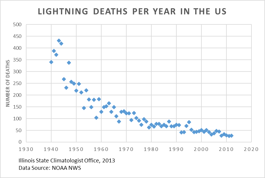
image001Good news for this Friday – lightning deaths have fallen dramatically since 1940. Using data from the NOAA NWS weather hazards page, reported lightning deaths in the US have declined to the point that they are now one-tenth of the number in the early 1940s.
I am not an expert on lightning deaths. However, I suspect one reason for the decline is due to changes in lifestyle including the end of WW II (less outdoor military training), more people working in offices, fewer people working on farms, etc. The other reason is the better communication over time on the general risk of lightning and better forecasts on the specific risk of thunderstorms.
Even with the decline in the number of deaths, it is still important to respect lightning and seek shelter when needed.
Data Source: http://www.nws.noaa.gov/om/hazstats/resources/weather_fatalities.pdf