
I dropped my car off at the shop for some brake work this morning here in Champaign and decided to walk to work. The air temperature was 21 degrees and the wind chill was 4 degrees. That was an uncomfortable stroll even with a winter coat, hat, and gloves. A year ago this morning (March 20, 2012), the air temperature was 63 degrees and well on its way up to a high of 82 degrees, a record high for this date.
So far this year, the statewide March temperature is 33.3 degrees. A year ago through this date, the statewide temperature was 51.1 degrees. That’s a whopping 17.8 degree difference. March went on to become the warmest March on record at 55.3 degrees, 14.2 degrees above the long-term average monthly March temperature of 41.1 degrees.
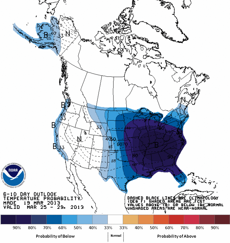
The rest of March does not look promising. The 1-5 day forecast shows temperature 10 to 14 degrees below average for Illinois. The 6-10 and 8-14 day forecast show widespread cold weather across Illinois and the central US. Figures below.
The long-term average temperatures for March were calculated from the 1981-2010 period.


Frost on the Pumpkin in Illinois
Here are the median dates of the first time we hit 32 degrees in the fall. Since we don’t have reports of when frost occurs, we use 32 degrees as a proxy. It is no surprise that the frost date occurs earlier in northern Illinois than southern Illinois.
If you look closely, you may see differences of several days between neighboring sites. Nighttime temperatures, especially on calm, clear nights in the fall, can be very sensitive to the local conditions. Sites in town tend to be a little warmer than those in the countryside, and result in delaying the arrival of colder temperatures.
Chilly temperatures have already visited the northern part of the state this weekend. Mt. Carroll reported a low of 29 on September 23 and Elizabeth reported a low of 28 on September 24.
You can read more about frost and see many more maps on the state climatologist’s frost webpage.

Lows for the Morning of April 11
After the record warmth in March left plants vulnerable to freezing temperatures, and with the average dates of the last freeze in mid April for most of Illinois, we were destined to get some damaging cold weather.
Here are the low temperatures reported for this morning from around the state (April 11):
| Station | Low |
| PAW PAW | 23 |
| MT CARROLL | 24 |
| WATSEKA 2 NW | 24 |
| NORMAL 4NE | 25 |
| MONMOUTH 4 NW | 25 |
| ALTONA | 25 |
| LISLE-MORTON ARBORETUM | 25 |
| LA HARPE | 26 |
| SULLIVAN | 26 |
| PRINCEVILLE 2W | 26 |
| MARSEILLES LOCK | 26 |
| GALENA | 26 |
| DWIGHT | 26 |
| NEOGA 4NW | 26 |
| PARIS WTR WKS | 27 |
| TUSCOLA | 27 |
| GALESBURG | 27 |
| DE KALB | 27 |
| MCHENRY STRATTON L&D | 27 |
| ELIZABETH | 27 |
| PERRY 6 NW | 27 |
| MUNDELEIN 4 WSW | 27 |
| PRAIRIE CITY 2S | 27 |
| EFFINGHAM | 27 |
| CARLINVILLE | 28 |
| MINONK | 28 |
| PONTIAC | 28 |
| WINDSOR | 28 |
| RAMSEY | 28 |
| MORRISONVILLE | 28 |
| BENTLEY | 28 |
| MORRIS | 28 |
| BARRINGTON 3 SW | 28 |
| FREEPORT WWP | 28 |
| BLOOMINGTON 5W | 28 |
| ROBINSON | 28 |
| ROCHELLE | 28 |
| ELGIN | 28 |
| ALEDO | 29 |
| OTTAWA | 29 |
| PANA | 29 |
| RUSHVILLE | 29 |
| KEWANEE 1 E | 29 |
| CHICAGO BOTANICAL GARDEN | 29 |
| WINCHESTER | 29 |
| OGDEN | 29 |
| SPRINGFIELD #2 | 29 |
| AURORA | 30 |
| OLNEY 2S | 30 |
| SPARTA | 30 |
| PARK FOREST | 30 |
| JOLIET BRANDON RD DM | 30 |
| FISHER | 30 |
| GRIGGSVILLE | 31 |
| KANKAKEE METRO WWTP | 31 |
| IUKA | 31 |
| CHICAGO MIDWAY AP 3 SW | 31 |
| JACKSONVILLE 2 E | 32 |
| JERSEYVILLE 2 SW | 32 |
| PITTSFIELD #2 | 32 |
| JACKSONVILLE 2 | 32 |
| STREATOR | 32 |
| MT VERNON 3 NE | 32 |
| WHITE HALL 1 E | 33 |
| GLADSTONE DAM 18 | 33 |
| NEW BOSTON DAM 17 | 33 |
| CHANNAHON DRESDEN ISLAND | 33 |
| ILLINOIS CITY DAM 16 | 33 |
| LAWRENCEVILLE | 33 |
| LEBANON | 33 |
| FLORA | 33 |
| SALEM | 33 |
| BIRDS 2E | 33 |
| NASHVILLE 1 E | 36 |
| QUINCY DAM 21 | 36 |
| BROOKPORT DAM 52 | 37 |
| SMITHLAND L&D | 37 |
| KASKASKIA RIV NAV LO | 37 |
| GRAND CHAIN DAM 53 | 40 |
| CAIRO 3 N | 42 |
Cold In Alaska
While Illinois enjoys a relatively mild winter, things are far different in Alaska. A colleague alerted me to these reports coming out of Alaska. I don’t know which is more impressive: the nighttime lows or the daytime highs.
REGIONAL TEMPERATURE AND PRECIPITATION ROUNDUP
NATIONAL WEATHER SERVICE FAIRBANKS AK
958 PM AKST SUN JAN 29 2012
 ALL VALUES ARE FOR 18 HOURS BETWEEN 3AM AND 9PM ALASKA
 LOCAL TIME TODAY
:
 SNOWFALL AND SNOW DEPTH DATA AVAILABLE ONLY AT AUGMENTED
 SITES
 PRECIPITATION DATA RELIABLE DURING THE WINTER ONLY AT
 AUGMENTED SITES
.B PAFG 0129 Z DH18/TXL/TNL/PPL/SF/SD
:
: ID           STATION            HI    LO    PCPN   SNOW SNOW
:                                                    FALL DEPTH
PAFA  : FAIRBANKS AIRPORT      : -38 / -51 /  0.01 /     /
PAEI  : EIELSON AFB            : -36 / -52 /    T  /     /
PANN  : NENANA                 : -26 / -54 /  0.00 /     /
PAMH  : MINCHUMINA             : -33 / -53 /       /     /
PAIN  : DENALI PARK            : -24 / -49 /       /     /
PABI  : DELTA JUNCTION         : -21 / -50 /  0.00 /     /
PAOR  : NORTHWAY AIRPORT       : -27 / -48 /    T  /     /   15
PAEG  : EAGLE                  :     /     /  0.00 /     /
PFYU  : FORT YUKON             : -51 / -62 /       /     /
PARC  : ARCTIC VILLAGE         : -42 / -54 /       /     /
PABT  : BETTLES                : -37 / -59 /  0.00 /     /   32
PAHL  : HUSLIA                 : -45 / -60 /       /     /
PAGA  : GALENA                 : -49 / -59 /    T  /     /
PAKV  : KALTAG                 : -44 / -56 /    T  /     /
PAMC  : MCGRATH                : -24 / -49 /  0.00 /     /   35
PAFS  : NIKOLAI                : -26 / -49 /    T  /     /
PANV  : ANVIK                  : -24 / -27 /       /     /
PAHC  : HOLY CROSS             : -25 / -30 /       /     /
:
PABR  : BARROW AIRPORT         : -19 / -24 /    T  /     /
PPIZ  : POINT LAY              : -19 / -24 /    T  /     /
PAWI  : WAINWRIGHT             : -14 / -20 /  0.00 /     /
PATQ  : ATQASUK                : -20 / -26 /       /     /
PAQT  : NUIQSUT                : -19 / -25 /  0.00 /     /
PASC  : DEADHORSE              : -18 / -25 /  0.00 /     /
PABA  : BARTER ISLAND          : -30 / -36 /  0.00 /     /
PAKP  : ANAKTUVUK PASS         : -31 / -36 /       /     /
:
PAOM  : NOME                   : -20 / -35 /  0.00 /     /
PAOT  : KOTZEBUE               : -32 / -39 /    T  /     /
PAPO  : POINT HOPE             :  -9 / -22 /       /     /
PAVL  : KIVALINA               : -24 / -27 /    T  /     /
PAWN  : NOATAK                 : -35 / -42 /       /     /
PAFM  : AMBLER                 :     /     /       /     /
PASH  : SHISHMAREF             : -17 / -24 /       /     /
PADE  : DEERING                : -19 / -38 /    T  /     /
PABL  : BUCKLAND               :     /     /       /     /
PAIW  : WALES                  :  -5 / -12 /       /     /
PATE  : TELLER                 :     /     /       /     /
PAGL  : GOLOVIN                : -27 / -35 /       /     /
PAKK  : KOYUK                  : -15 / -29 /       /     /
PAUN  : UNALAKLEET             : -17 / -27 /       /     /
PACM  : SCAMMON BAY            : -17 / -22 /       /     /
PAMK  : SAINT MICHAEL          : -23 / -26 /       /     /
PAEM  : EMMONAK                : -17 / -20 /       /     /
PASM  : SAINT MARYS            :  -9 / -17 /       /     /
.END
 COOPERATIVE OBSERVATIONS
 ALL VALUES ARE FOR 24 HOURS ENDING AROUND 9AM ALASKA
 LOCAL TIME TODAY
.B PAFG 0129 Z DH17/TX/TN/PPD/SF/SD
:
: ID           STATION            HI    LO    PCPN   SNOW SNOW
:                                                    FALL DEPTH
PATA  : TANANA                 : -47 / -61 /  0.00 /     /   20
GSCA2 : GOLDSTREAM CREEK       : -41 / -55 /  0.00 /  0.0/   17
FYKA2 : FORT YUKON #2          : -39 / -65 /  0.00 /  0.0/   22
FAOA2 : COLLEGE OBSERVATORY    : -38 / -48 /  0.00 /  0.0/   17
STHA2 : MILE 42 STEESE HWY     :     /     /       /     /
DNPA2 : DENALI PARK HQ         : -27 / -37 /  0.00 /  0.0/   23
HLYA2 : HEALY 2NW              : -30 / -41 /  0.00 /  0.0/    8
LMHA2 : LAKE MINCHUMINA        : -39 / -50 /  0.00 /  0.0/   18
CHSA2 : CIRCLE HOT SPRINGS     : -49 / -58 /  0.00 /  0.0/   20
PRCA2 : PORCUPINE RVR AT COLEEN:     /     /       /     /
RUBA2 : RUBY 14NE              :     /     /       /     /
BIGA2 : DELTA JUNCTION 20SE    : -40 / -58 /  0.00 /  0.0/   19
DDAA2 : DELTA 6N               :     /     /       /     /
PACA2 : PORT ALCAN             : -36 / -49 /  0.00 /  0.0/   13
CQNA2 : CHICKEN COOP           : -43 / -59 /  0.00 /  0.0/   14
EGLA2 : EAGLE                  : -40 / -57 /  0.00 /  0.0/   18
CCVA2 : COLVILLE VILLAGE       : -17 / -37 /    T  /    T/    8
WITA2 : WHITESTONE FARMS       : -38 / -52 /  0.00 /  0.0/   11
.END
 COOPERATIVE OBSERVATIONS
 ALL VALUES ARE FOR 24 HOURS ENDING AROUND 2PM ALASKA
 LOCAL TIME TODAY
.B PAFG 0129 Z DH23/TX/TN/PPD/SF/SD
:
: ID           STATION            HI    LO    PCPN   SNOW SNOW
:                                                    FALL DEPTH
GCQA2 : GILMORE CREEK          : -23 / -47 /  0.00 /  0.0/   16
DRYA2 : DRY CREEK              : -32 / -54 /  0.00 /  0.0/   26
TOFA2 : TOK FORESTRY           :     /     /       /     /
ACLA2 : ALPINE CREEK LODGE     :     /     /       /     /
.END
 COOPERATIVE OBSERVATIONS
 ALL VALUES ARE FOR 24 HOURS ENDING AROUND 6PM ALASKA
 LOCAL TIME TODAY
.B PAFG 0129 Z DH03/TX/TN/PPD/SF/SD
:
: ID           STATION            HI    LO    PCPN   SNOW SNOW
:                                                    FALL DEPTH
TOKA2 : TOK                    :     /     /       /     /
TOAA2 : TOK #2                 : -27 / -51 /  0.00 /  0.0/   22
GALA2 : GALENA                 : -50 / -65 /  0.00 /  0.0/   32
WSMA2 : WISEMAN                :     /     /       /     /
KOBA2 : KOBE HILL              :     /     /       /     /
PALP  : ALPINE                 : -18 / -31 /    T  /    T/   29
MISSI : MISSING                :     /     /       /     /
DIKA2 : KANDIK RIVER           : -52 / -64 /  0.00 /  0.0/   22
.END
 COOPERATIVE OBSERVATIONS
 ALL VALUES ARE FOR 24 HOURS ENDING AROUND 10PM ALASKA
 LOCAL TIME TODAY
.B PAFG 0129 Z DH06/TX/TN/PPD/SF/SD
:
: ID           STATION            HI    LO    PCPN   SNOW SNOW
:                                                    FALL DEPTH
AURA2 : AURORA/FAIRBANKS       : -40 / -51 /    T  /    T/   17
CSKA2 : CLEAR SKY              : -42 / -60 /  0.00 /  0.0/   18
NOPA2 : NORTH POLE             :     /     /       /     /
FMTA2 : FAIRBANKS MIDTOWN      :     /     /       /     /
.END