Three Dog Night for Illinois As Extremely Cold Air Arrives

A cold-air outbreak is expected to impact a large part of the US east of the Rockies. Lows tonight expected to drop below zero tonight (first map) across Illinois and most of the Midwest. These extremely cold temperatures will come close to the record lows for February 19 in many locations in the state, but is not likely to break them.

Strong winds out of north are expected as well, causing NWS to issue a wind chill advisory for Illinois as windchill values fall into the minus teens and twenties. Values in this range can lead to frostbite of exposed skin in 30 minutes or less, as well as greatly increase the risks of hypothermia. Stay tuned to your local forecasts as this situation develops.

Even before this cold air outbreak, the statewide average temperature for February in Illinois was 4.4 degrees below average.

nws1Note #1. You can see how windchill is calculated on this NWS web page.

Note #2. Three dog night is a folk expression of how many dogs you will need to stay warm at night [one dog night = cold, two dog night = colder, three dog night = coldest].
February Snowfall in Illinois

Much of the southern third of Illinois received between 1 and 12 inches in this last winter storm. The highest amount reported was 12.5 inches at Smithland with several other stations reporting in the 7 to 8 inch range, including Jerseyville with 7.8 inches, Newton with 7.8 inches, and Brookport Dam with 8.8 inches.

map1The northern third of Illinois received a considerable amount of snow from the January 31 – February 2, 2015 storm.

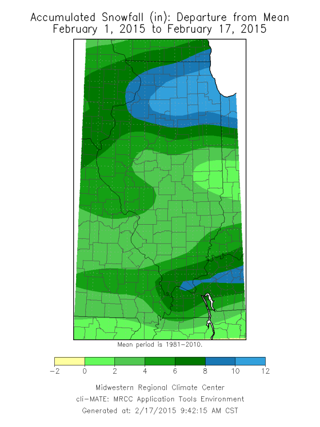
As a result, total February snowfall has ranged from 15 to 20 inches in northeast Illinois and widespread amounts of 5 to 15 inches across the state (first map below). As a result for the month to date, most of the state is 1 to 8 inches above average except for the northeast which is 8 to 12 inches above average (second map below).

map2map3

Now You See It – Now you Don’t, Drought Monitor Removes D0 in Illinois

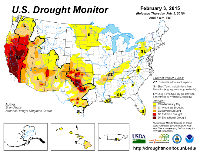
There is an inside joke for those of us who work with the folks at the US Drought Monitor. If you want to make it rain (or snow), just put an area in D0 “abnormally dry” and the heavens will open up. That’s basically what happened this week – the rain and snow in Illinois reduced the concern of dry conditions across the state. As a result, the D0 in northern and western Illinois has been removed.

By the way, it is a lot easier to move in and out of “abnormally dry”. It becomes increasingly difficult to recover from drought as you increase the intensity and duration of the drought. 20150203_usdm_home

After Slow Start to Snow Season, Illinois Catching Up

After a slow start to the snowfall season in Illinois, we are now catching up. Heavy snow fell across northern Illinois over the weekend and more snow is arriving today.

The Chicago NWS office has a nice write-up on the recent historic winter storm that stretched all the way across Illinois and into Indiana. We can call it a historic winter storm because it was the fifth largest in Chicago history with 19.3 inches reported at O’Hare airport.

Here are our snowfall departure from average as of a week ago and as of this morning. Northern Illinois went from a deficit of 1 to 8 inches to a surplus of 1 to 8 inches in green and 8 or more inches in blue. And more snow is falling as I write this so some of the deficits across central Illinois may be erased soon.

xjan29
Snowfall departure from average as of January 29, 2015. Click to enlarge.
xfeb4
Snowfall departure from average as of February 4, 2015. Click to enlarge.