The University of Illinois Extension has just released a new web site dealing with drought and heat, including issues related to crops, livestock, home and garden, and finances. Check it out at:
First Half of July – Hot and Dry
Rainfall
The statewide average rainfall for Illinois in the first half of July is only 0.8 inches. That is 1.2 inches below average or 40 percent of average. The statewide 1981-2010 average rainfall for the first half of July is 2.0 inches.
The driest July on record was July 1930 with only 1.01 inches. Next in line was 1916 with 1.23 inches and 1936 with 1.24 inches. More recently, 1983 came in 12th place with 1.93 inches and 1988 came in 25th place with 2.60 inches.
Temperature
The statewide average temperature for the first half of July was 82.0 degrees, 6.2 degrees above average. The hottest July on record was 1936 at 83.1 degrees.
Based on preliminary data, there have been 186 new daily records set in July so far and another 33 tied previous records. You can check out the records yourself at http://www.ncdc.noaa.gov/extremes/records/.
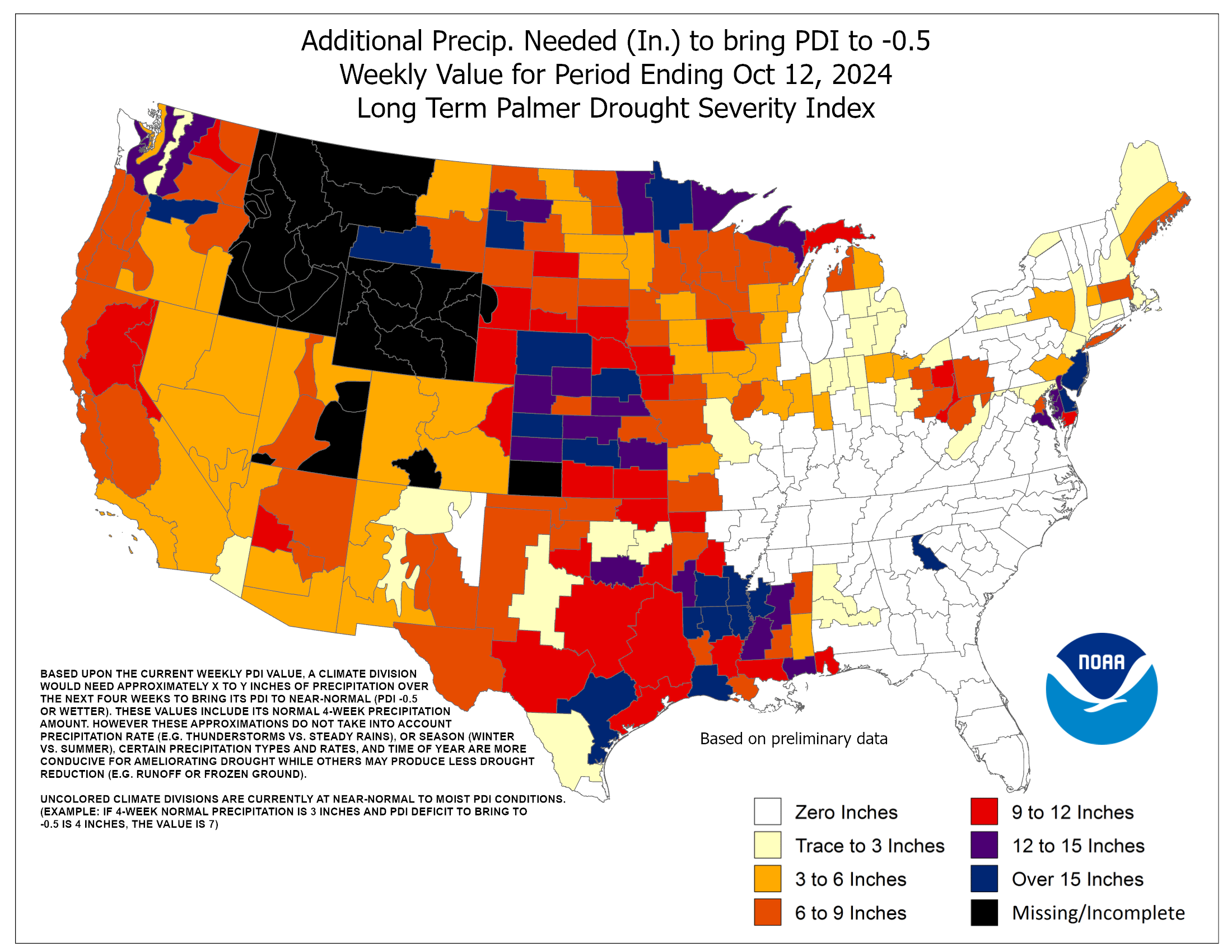
How Much Rain Do We Need to End the Drought
[Updated July 20 for a more frequently updated map from the Climate Prediction Center]
People have asked me several times this week, “how much rain do we need to end the drought?”
There is no easy way to answer this. The normal rainfall per week in Illinois is about an inch. So we need that inch per week just to keep from slipping farther behind. Taking it a step farther, that means you need well over an inch per week to start recovering from drought. Of course, no amount of rain at this point will undo the damage done to crops already.
There is one product, based on the Palmer Hydrological Drought Index, that attempts to answer this question from the Climate Prediction Center. However, I would treat it as an estimate. Even so, it gives you an idea of how far we have to go for a recovery. They estimate that we would have needed 9 to 15 inches of rain across much of Illinois to end the drought. That is a tall order. The wettest July on record for Illinois is 8.03 inches in 1958 and the wettest August on record was 6.91 inches in 1977.
Personally, I’m not sure it would take record-breaking rainfall. And I’m not sure we want 9 to 15 inches over the course of one or two months because that could lead to all kinds of other problems like flooding and heavy soil erosion.
Based on past droughts in Illinois, a month with rainfall 50 percent above normal (around 6 inches) followed by several months with near-normal rainfall would be capable of turning things around without the more serious consequences of heavy rainfall.

Drought Worsens in Illinois
The U.S. Drought Monitor just increased the drought coverage in Illinois to 100 percent. In addition, the area of D2 “severe drought” expanded in eastern Illinois and east of St. Louis and along the Illinois-Wisconsin border.
The statistics for July so far (July 1 – 11) show why the drought has worsened so quickly. The statewide average precipitation was 0.5 inches, just 37 percent of what we would normally receive in the first 11 days of July. The statewide average temperature during this time was 83.1 degrees, 7.5 degrees above normal.
The table that accompanies the map has some interesting statistics. A year ago at this time there was no drought in Illinois thanks to an exceptionally wet spring and early summer. And this year started out with no drought in Illinois. Even three months ago only a small part of southern Illinois (5 percent) was considered in a moderate drought.
The U.S. Drought Monitor is a joint effort between NOAA, USDA, and the National Drought Mitigation Center. They do consider local input on drought impacts. If you have any impacts – text and/or picture – that you would like to include for consideration, please contact me at jimangel@illinois.edu – thank you.


