End of the Snow Drought in Illinois

With the looming winter storm expected to reach Illinois on Wednesday and Thursday, we should see the end of the 2012 snow drought in Illinois. Last winter’s snowfall season was cut short by warm and dry conditions in February and March. Meanwhile, the start of this winter’s snowfall was much delayed by the warm, dry conditions of the past several weeks. As a result, many sites in northern and central Illinois approached or set their records for the longest snow-free period.
Here is the map of total snowfall for this winter through December 17, how much we normally get through December 17, followed by reports on the remarkable snow-free season in Illinois. A few sites in western Illinois reported snowfall this morning.
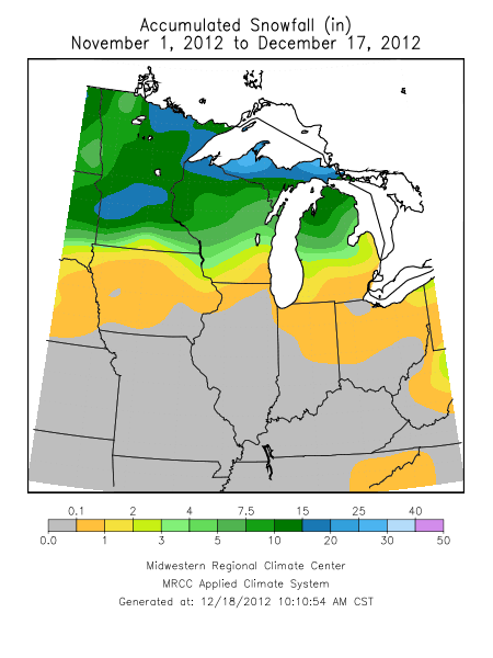
dec17snow

Normal snowfall from November 1 to December 17 for the period 1981-2010.

Here is the report for Chicago. Here are additional reports for central Illinois and northwest Illinois.

PUBLIC INFORMATION STATEMENT
NATIONAL WEATHER SERVICE CHICAGO IL
1153 AM CST MON DEC 17 2012 /1253 PM EST MON DEC 17 2012/
...LATEST ON SNOWFALL RECORDS...
SUNDAY DECEMBER 16TH MARKED THE 287TH CONSECUTIVE DAY WITHOUT
MEASURABLE SNOWFALL AT ROCKFORD...BREAKING THE PREVIOUS
CONSECUTIVE DAY RECORD THAT HAD BEEN SET IN 1922. THIS IS NOW THE
LONGEST PERIOD OF TIME WITHOUT MEASURABLE SNOWFALL IN ROCKFORD ON
RECORD. THE LAST DAY WITH MEASURABLE SNOWFALL WAS MARCH 4TH.
CHICAGO HAS ALREADY BROKEN THEIR RECORD.
ROCKFORD
RANK # DAYS DATES W/O MEASURABLE SNOW
 1) 287 03/05/2012-12/16/2012+
 2) 286 03/03/1922-12/13/1922
 3) 284 02/26/1908-12/05/1908
 4) 282 03/31/1939-01/06/1940
 5) 270 03/06/2011-11/30/2011
 270 03/10/1999-12/04/1999
CHICAGO
RANK # DAYS DATES W/O MEASURABLE SNOW
 1) 287 03/05/2012-12/16/2012+
 2) 280 03/01/1994-12/05/1994
 3) 277 03/10/1946-12/11/1946
 4) 269 03/11/1999-12/04/1999
ON AVERAGE...CHICAGO HAS 226 DAYS IN A ROW WITHOUT MEASURABLE
SNOWFALL /SEVEN AND A HALF MONTHS/ AND ROCKFORD HAS 233 /ALMOST
EIGHT MONTHS/.
GIVEN THE CURRENT FORECAST...IT APPEARS BOTH LOCATIONS COULD HAVE
THEIR RECORD SNOW DROUGHT PERIODS COME TO AN END ON WEDNESDAY NIGHT
OR THURSDAY...WITH EVEN THE POSSIBILITY OF A BRIEF SNOW EARLIER ON
TUESDAY MORNING.
HERE ARE SOME STATISTICS REGARDING FIRST/LAST MEASURABLE SNOWFALLS...
CHICAGO ROCKFORD
 EARLIEST: 10/12/2006 10/12/1909
1ST AVERAGE: NOV 16 NOV 20
 LATEST ??/??/2012 01/07/1940
EARLIEST: 02/27/1997 02/06/1911
LAST AVERAGE: APR 4 APR 1
 LATEST 05/11/1966 05/11/1966
HERE ARE THE LATEST FIRST MEASURABLE SNOWFALLS FOR CHICAGO AND
ROCKFORD...
CHICAGO ROCKFORD
1) ??/??/2012 1) 01/07/1940
2) 12/16/1965 2) 12/21/1996
3) 12/14/2001 3) 12/19/2001
4) 12/12/1946 12/19/1948
5) 12/10/2003 5) ??/??/2012
6) 12/09/2011 6) 12/14/1922
 12/09/1948 7) 12/12/1916
8) 12/07/1914 8) 12/11/1924
9) 12/06/1994 9) 12/10/1970
10) 12/05/1999 12/10/1932
 12/05/1984 11) 12/08/1956
 12/05/1973 12/08/1927
 12/05/1909 12/08/1914
$$
MTF/RODRIGUEZ
Chances of a White Christmas

What are the chances of a White Christmas (defined as at least an inch of snow on the ground on Christmas Day)? The National Climatic Data Center has updated their US map to show the current 1981-2010 averaging period. The odds are high in the Rocky Mountains, the upper Midwest, and the Northeast. However, a White Christmas is rarely, if ever, seen in much of the southern half of the US or along the West Coast.
We did a similar map with more detail for Illinois last year (second map).  It should come as no surprise that the highest odds are in northern Illinois.  In general, the odds are about 40-60 percent in the northern third of Illinois, 20-40 percent in central Illinois, and 0-20 percent in southern Illinois.
There can be large differences from site to site. Snowfall is notoriously difficult to measures with two nearby sites having different results due to exposure to sun and wind.

Chances of a White Christmas across the US. National Climatic Data Center (NOAA).

odds of a white Christmas
The odds of a white Christmas in Illinois, based on 1981-2010 data. Click to enlarge.

First Snow in Illinois


The other night we had a brief period of snow with no accumulation on the ground here in Champaign. However I did see some on my car for a few minutes (see right) before it melted. That reminded me that Zoe and I had worked on some “first snowfall” maps. These maps are based on sites that reported snowfall regularly since 1981. The dates are the earliest and median dates of the first measurable snow (0.1 inches or more) for the standard averaging period of 1981 to 2010 (also known as “normal”).
No real surprises for anyone who has experienced winter in Illinois. The earliest dates are in the late October, early November time frame. And the median dates range from late November in northern Illinois to the second half of December in southern Illinois. Even so, the dates can vary considerably between nearby sites since many of the early season snows are sporadic and not very widespread.
The median is also known as the 50th percentile and represents in the “middle” of the distribution of dates. In many cases it is a better measure than the average, which can be thrown off by some date that is extraordinarily early or late.

Earliest measurable snow in Illinois for the period from 1981 to 2010. Click to enlarge.

Median date of the first measurable snowfall in Illinois for the period from 1981 to 2010. Click to enlarge.

Getting Around Illinois in Winter

The Illinois Department of Transportation maintains a website called http://www.gettingaroundillinois.com/ According to the site,

Getting Around Illinois is a web-based interactive mapping site that provides the ability to search and display several sources of transportation data. You can find information on winter road conditions, average annual daily traffic, road construction, trucking routes, and planned road projects.

From that main page, you can get current winter road conditions at http://wrc.gettingaroundillinois.com/pages/wrc.htm. I have found this site to be very valuable for  making travel plans during or after a winter storm in Illinois.

Have you ever noticed the weather instruments alongside Interstate Highways? Those systems are called Road Weather Information Systems, or RWIS for short. They include weather sensors as well as roadway sensors to measure pavement temperatures and detect wet or icy conditions. Here is the link for the RWIS data in Illinois: http://www.gettingaroundillinois.com/mapviewer.aspx?mt=rwis