The statewide average precipitation was 2.06 inches, 1.6 inches below average and 56 percent of average. This was the 13th driest August on record since 1895, based on preliminary data.
The driest area was south of and parallel to Interstate 74 (Figure 1). Rainfall amounts in that region were generally an inch or less. One of the driest spots in Illinois was Lovington (Moultrie County in east-central Illinois) with only 0.03 inches for the entire month. Other familiar sites with extremely low readings included: Decatur with 0.15 inches, Springfield with 0.25 inches, and Quincy with 0.25 inches.
Only northern Illinois received average to above-average rainfall in August (Figure 2). One of the wettest spots in Illinois was Morris (Grundy County) with 7.02 inches, followed closely by Earlville (LaSalle County) with 7.01 inches.
Moderate to severe agricultural drought arrived in Illinois in August (Figure 3), according to the US Drought Monitor. This was the result of much less than average rainfall in July and August, as well as warmer than average temperatures. Damage to corn and soybean crops appears to be significant in places. However, the full extent of the damage will not be known until harvest.
Temperatures were above average for much of Illinois (Figure 4). Highs in the 90s and even low 100s were common across the state. The hottest spots in the state were Cairo with 103 degrees on August 4 and Bentley with 103 degrees on August 25. Both Quincy and Grand Chain Dam were close with 102 degrees on August 2 and August 4 respectively.
The statewide mean temperature (an average of both the high and low temperatures) was 74.9 degrees, 1.2 degrees above average.


VegDRI: A view of Illinois corn and soybean crops from space
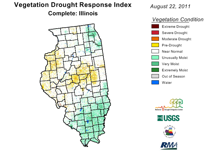
There is a new way to look at drought stress in Illinois – from space. Called VegDRI, this product integrates “satellite-based observations of vegetation conditions, climate data, and other biophysical information such as land cover/land use type, soil characteristics, and ecological setting. The VegDRI maps that are produced deliver continuous geographic coverage over large areas, and have inherently finer spatial detail (1-km resolution) than other commonly available drought indicators such as the U.S. Drought Monitor,” according to the VegDRI website.
In other words, it looks at crop stress as it relates exclusively to drought. The maps are updated every two weeks.
The August 22, 2011, map below shows that crops in much of western and central Illinois are showing much stress from the lack of rain and high temperatures in July and August. If you go to the VegDRI website, you can see a national map. Click on a state to get a closer view. Scroll down the state page and click on the quadrant map of the state so see even more detail.


The National Drought Mitigation Center produces VegDRI in collaboration with the US Geological Survey’s (USGS) Center for Earth Resources Observation and Science (EROS), and the High Plains Regional Climate Center (HPRCC), with sponsorship from the US Department of Agriculture’s (USDA) Risk Management Agency (RMA). Main researchers working on VegDRI are Dr. Brian Wardlow and Dr. Tsegaye Tadesse at the NDMC, and Jesslyn Brown with the USGS, and Dr. Yingxin Gu with ASRC Research and Technology Solutions, contractor for the USGS at EROS.
Hot, Humid Weather and Crops
Temperatures in Illinois this week have ranged from the upper 90s to the low 100s. At times the night-time lows have been in the upper 70s and low 80s as a result of the high humidity.
Emerson Nafziger, University of Illinois Extension, has a thoughtful discussion about the effects of these conditions on crops in Illinois. In general, high day-time temperatures are not a major concern for corn until they get above 100 degrees. Other potential problems include: high night-time temperatures leading to higher losses of sugars available for crop growth; high humidity levels increasing the risk of foliar disease; and the lack of rain in parts of Illinois since the beginning of July leading to reduced photosynthesis.
You can read the full story on the University of Illinois web site “The Bulletin: Pest Management and Crop Development Information for Illinois” High Temperatures and Crops.
30-Day Dry Spot in Corn Belt
As of July 13, 2011, the map of 30-day precipitation departures (figure below) showed a large area of below-average precipitation extending from eastern Iowa, through Illinois and Wisconsin and into parts of Michigan, Indiana, and Ohio. At first, this was not a concern because of the wet conditions that occurred through much of the spring. However, the lack of rainfall and hot conditions in the first part of July have begun to dry out the topsoil in Illinois. The rainfall departures range from 0.5 to 3 inches below average across northern and eastern Illinois.
Comparing the NASS report for July 5 and July 11:
- the Northwest crop reporting district (CRP) went from 11% dry to very dry topsoil to 30% dry to very dry in one week
- the Northeast CRP went from 4% dry to very dry to 29% dry to very dry in one week
- the East CRP went from 12% dry to very dry to 37% dry to very dry in one week.
The potential loss of water from soils from evaporation and transpiration from crops is on the order of 0.2 inches per day in Illinois now (link to potential evapo-transpiration maps). That means that we need about 1.4 inches of rain per week in July just to keep up with the demand from the crops. If the crops don’t get the water from rainfall then they have to rely more on soil moisture. So a week with no rain and temperatures in the 90s can dry out the topsoil quickly.
According to the Crop Watchers in the Illinois Farm Bureau’s FarmWeek, corn and soybeans in the sandy soils and in the thin soils on the ridges are showing signs of stress. Today we have seen slightly cooler temperatures across Illinois, along with some rain. However, the NWS is forecasting a return of hot weather over the weekend. In addition the NWS 6-10 day and 8-14 day forecast show a greater chance of above-average temperatures across all of Illinois. Those forecasts show a greater chance of below-average rainfall across the southern two-thirds of the state and near-to-above average rainfall in the northern third of the state.
While northern Illinois has been dry, much of southern and western Illinois has received much-above average rainfall, by as much as 2 to 5 inches or more in many locations. The wet conditions have led to flooded fields and widespread planting/replanting delays.


