Champaign-Urbana Illinois Gets Soaked

Heavy rains fell over Champaign-Urbana, Illinois on Saturday with more rain early Sunday morning. The two-day total through Sunday morning was 4.42 inches at the official NWS COOP station at the Illinois State Water Survey near the corner of First and Windsor in Champaign. Here is the breakdown by day, with the official observation time at 8 am:

  • 0.09 inches of rain by 8 am July 12
  • 4.33 inches of rain by 8 am July 13

The 4.33 inches for July 13, 2014, at the official, long-term site for Champaign-Urbana, falls short of the historical record 1-day total, which is 5.32 inches of rain from August 12, 1993.

Here are the reports from the CoCoRaHS network for Champaign-Urbana, showing two reports of over 5 inches, and several reports of between 4 and 5 inches.

GetMap

Here is a wider view showing the rains of the last two days from a NWS product that combines radar and rain gage information. The amounts of 2.5 to 4 inches stretches from Chicago down to east-central Illinois with the heaviest amounts of possibly up to 6 inches in Champaign, Piatt, McLean, and Ford counties.

july13-mpe

June in Illinois – Warmer and Wetter Than Average

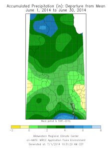
The statewide average precipitation for June 2014 in Illinois was 6.78 inches, 2.58 inches above average and the 8th wettest June on record. The wettest June on record was 1902 with 8.27 inches. Four out of the last five June’s have been wetter than average in Illinois:

  • 2010: 7.71 inches, 3.51 inches above average
  • 2011: 6.69 inches, 2.49 inches above average
  • 2012: 1.73 inches, 2.47 inches below average
  • 2013: 5.33 inches, 1.13 inches above average
  • 2014: 6.78 inches, 2.58 inches above average 

The statewide average temperature for June 2014 in Illinois was 72.9 degrees, 1.1 degrees above average.

Here are the maps of accumulated rainfall in June, 2014, as well as the departure from the 1981-2010 average. The rainfall was widespread across the state, and above-average as well. The area with the highest departures was the northwest corner of the state. There were 13 stations with 10 or more inches of rain in June. The wettest was Galena with 12.42 inches of rain for the month.

Much of the Corn Belt was wetter than average for June (last map) with precipitation departures from average in the range of 6 to 10 inches. That’s more than double the average in many locations. The results are high flows on many rivers and streams and flooding along the main stem of the Mississippi River south of Dubuque, IA.

fig1
Click to enlarge.
fig2
Click to enlarge.
fig3
Click to enlarge.