NWS Outlook for November and Winter

Today the NWS Climate Prediction Center has released their latest outlook for November and this winter. Below are the maps for November temperature, November precipitation, December-February temperature, and December-February precipitation.

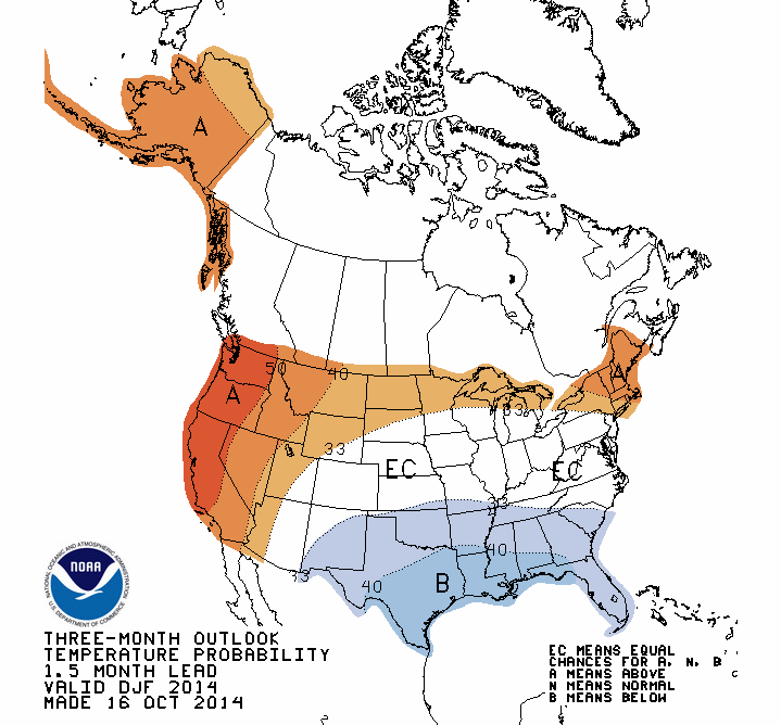
For Illinois, November temperatures have equal chances (EC) of being above, below, or near-average. November precipitation is rated as EC except for the northeast quarter of the state, which has an increased chance of below-average precipitation. This is part of a larger area with increased chances of below-average precipitation across the Great Lakes region.

The category of EC is a little hard to interpret. Basically, it means that there are no consistent indications that conditions could be too warm/cold/wet/dry. Sometimes I call it a neutral forecast.

For December-February, the traditional winter months, Illinois has equal chances (EC) of above, below, and near-average temperatures. However, Illinois has an increased chance of below-average precipitation.

Continue reading “NWS Outlook for November and Winter”

October Cooler and Wetter Than Average So Far in Illinois

The statewide average temperature for October so far in Illinois is 56.5 degrees, 1.4 degrees below average. The statewide average precipitation for October so far is 2.5 inches.

Here is the map showing how the precipitation has fallen in Illinois and surrounding states. The heaviest amounts in Illinois were the 3 to 5 inches between Interstates 70 and 74. Amounts of 1 to 3 inches were common in the northern and southern thirds of the state. The largest total so far is 8.38 inches reported at Greenfield in Greene County

Most of Missouri has seen amounts of 3 to 6 inches or more as well as parts of Indiana and Michigan. It was a little drier in the Minnesota, Wisconsin, Iowa, Ohio and the rest of Indiana where amounts of 0.5 to 2 inches were common.
map_btd  Continue reading “October Cooler and Wetter Than Average So Far in Illinois”

Weather Outlook for Fall and Winter in Illinois

The NOAA Climate Prediction Center released their monthly outlook for September and 3-month outlooks for September and beyond. At this time, they are not expecting a repeat of last winter for Illinois.

According to them, the chance of El Niño has decreased to about 65% during the Northern Hemisphere fall and early winter. If it does show up, it is expected to a moderate to weak event. As a result, the impacts on the US and the Midwest will likely be modest at best.

September and FALL

For both September and this fall, there is an equal chance (EC) of above, below, near-average temperature and precipitation (4-panel figure below) for Illinois. The north-central US is not expected to have below-average temperatures, like it has experienced this summer. This may give crops in those areas a better chance of reaching maturity this fall.

It does look like temperatures are expected to stay above-average on the West and East Coast, as well as Alaska. Wetter-than-average conditions are expected to prevail in the southwest US, and expand into the Plains and parts of Iowa and Missouri later in the fall.


page2


WINTER (December-February)

For Illinois, the current forecast is for equal chances of above, below, and near-average temperatures. Or to put it another way, they see no sign of a repeat of last winter. And they are expecting below-average precipitation in Illinois and across the Great Lakes region. It is still early in the year to lock in on this forecast so I would not cancel orders for snow blowers or salt deliveries just yet.

off04_tempoff04_prcp

First Half of May in Illinois – Warm, Wet, And Then Snow

According to preliminary records, the first half of May was both warmer and wetter than average for many locations in Illinois. The statewide average temperature was 61.2 degrees, about 1.4 degrees above average. Meanwhile, this morning there are reports of snow falling in northern Illinois. Talk about weather extremes. This was after last weekend when we saw widespread reports of highs in the upper 80s and low 90s.

The statewide average precipitation was 2.43 inches, 18 percent above average. Here is a screenshot of the last 14 days showing the widespread and heavy rainfall in much of the northeast, east-central, and southern parts of Illinois with many sites reporting between 3 to 6 inches of rain. Parts of western and central Illinois have not been as wet with amounts in the range of 1 to 3 inches of rain.
14days


Snow in May? Read more on the Chicago NWS page. It looks like Rockford set a new record for the latest report of snowfall in the season. The Chicago record still stands at June 2, 1910.

snow
Map courtesy of the Chicago NWS office.