There is a 95% chance that El Niño will continue through winter and gradually weaken through spring 2016, according to the NOAA Climate Prediction Center today. That remains essentially unchanged from last month’s outlook. As noted in a earlier post, this increases the chances of a mild winter in Illinois.
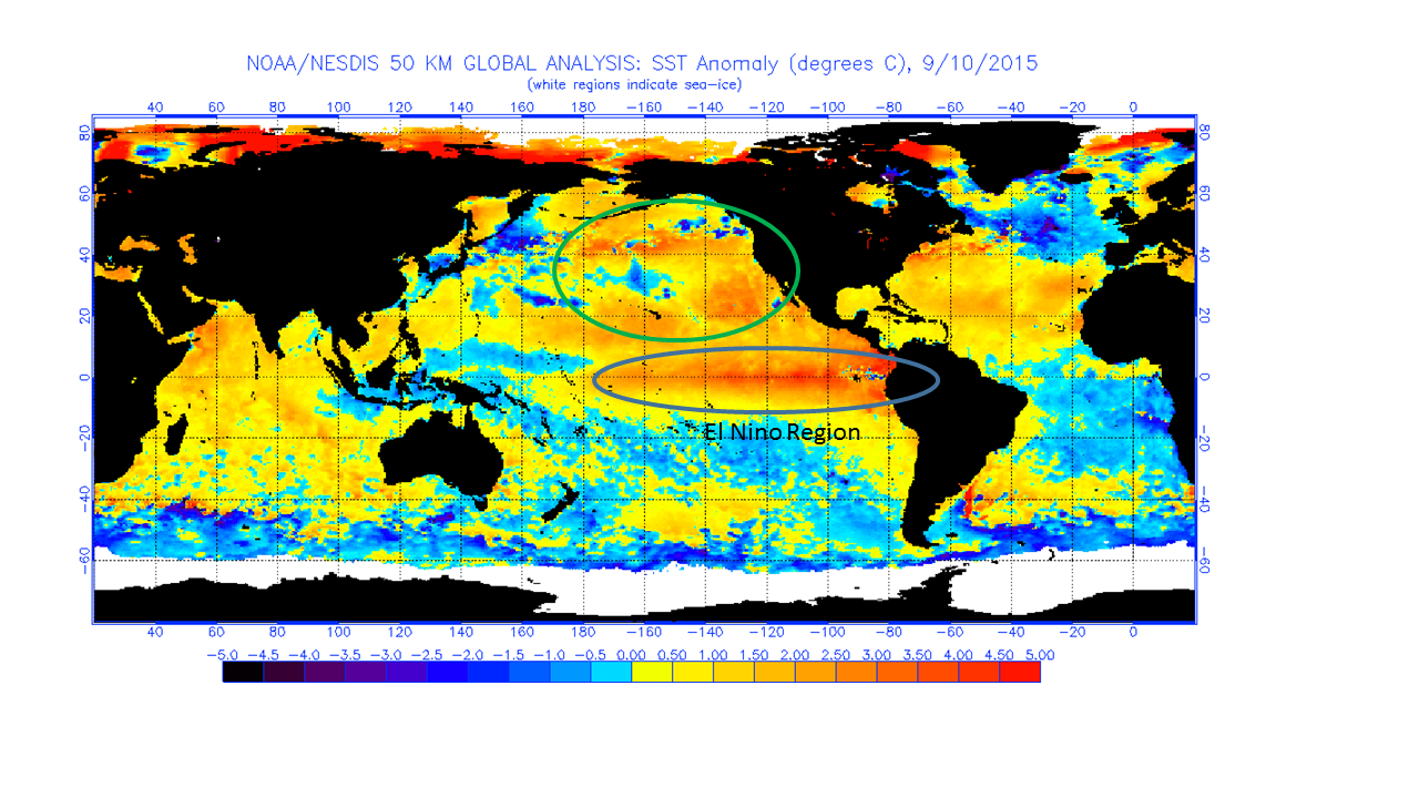
Here are the recent sea surface temperatures, as a departure from the average, in the Pacific Ocean basin. The units are in degrees Celsius, so just double the number to get the approximate departure in degrees Fahrenheit. This represents an impressive amount of heat, considering that these warmer water temperatures cover thousands of square miles.
The traditional area for El Niño formation is circled and labeled on the map. The one wild card in the current situation is that we have exceptionally warm waters farther to the north than what I have seen in past El Niño episodes (green circle). This could potentially change the impacts of El Niño over North America.
Click to enlarge. Source NOAA http://www.ospo.noaa.gov/Products/ocean/sst/anomaly/
The Australian Bureau of Meteorology announced today (April 8) that for our summer (their winter):
It is now likely (estimated at a greater than 70% chance) that an El Niño will develop during the southern hemisphere winter … surface and sub-surface ocean temperatures have warmed considerably in recent weeks, consistent with a state of rapid transition [to El Niño]
The Australian Bureau of Meteorology has had a long history of monitoring and understanding conditions in the tropical Pacific Ocean because they are directly impacted. The US Climate Prediction Center’s last statement, released on March 6, indicated only a 50% chance of El Niño development by this summer and that the timing would be a little later in the season. The next US statement on conditions in the Pacific Ocean is expected to be released April 10. I suspect the odds of occurrence and timing of an El Niño event will change somewhat in that statement.
El Niño Forecast
Here is the Australian El Niño forecast for the rest of 2014, showing a rapid warming of eastern Pacific Ocean temperatures across the temperature threshold for El Niño of +0.8 C by June, and continuing to warm for the rest of 2014.
Another one of their figures found here, shows the sub-surface temperatures in the Pacific Ocean the TAO network of buoys in the Pacific. Imagine looking at the side of an aquarium and you could see the different water temperatures in the tank. This graph is looking at the side-glass of the Pacific Ocean right along the equator. On the left side is the western Pacific, and on the right side is the eastern Pacific (where El Niños occur).
The second panel is most interesting because it shows anomalies (i.e., differences) from the long-term average ocean temperatures. Just under the surface in the eastern Pacific between 20 and 100 meters is a large pool of warmer-than-average water. The temperatures are 2 to 5 degrees C warmer (4 to 10 degrees F). There is another larger, deeper pool farther to the west at about 150 meters. As they describe it, “this pool of warmer-than-average sub-surface water is expected to cause a further warming at the surface of the tropical Pacific, which is now likely to contribute to the formation of an El Niño” during our summer in Illinois.