The latest US Drought Monitor map shows an expanded area in south-central Illinois that is completely drought-free at this point (7% of the state). In general, that area has received 8 to 16 inches of rain since August 1, which is about 4 to 8 inches above normal. The largest station total was 23.38 inches in Grayville, followed by Centralia IL with 20.01 inches.
Meanwhile, western and northern Illinois have not seen significant drought recovery so far this fall. Those areas have received only 2 to 6 inches of rain, where normal rainfall in that region is on the order of 8 inches.
Another thing that has helped recently with the drought situation in Illinois is that temperatures have run below normal since August. Most recently, October 1-10 has been 6 degrees below normal.

Rainfall Totals from Tropical Storm Isaac
Tropical Storm Isaac dropped a lot of rain on Illinois over the Labor Day weekend. As noted in an earlier post, tropical storms are rare in Illinois but they do happen. However, this one was especially interesting because the heavy rains fell over areas in drought across the state. In a normal year, such heavy rains would have produced widespread flooding in low areas, streams, and small rivers. But not this year. I have not heard any reports of significant flooding. This suggests that the dry soils absorbed most of the rainfall. And what little runoff was produced, ended up in streams that were much below-normal. More on this in another post.
The first map shows the 7-day rainfall totals from Tropical Storm (TS) Isaac. The areas in red had over 4 inches of rain. Areas north of Interstate 80 saw little of the rainfall.
The second map shows the 30-day rainfall totals. Parts of Illinois already had substantial rainfall before TS Isaac. With the addition of the rainfall from Isaac, much of central and southern Illinois had accumulated over 4 inches of rain. In fact, some areas had over 6 inches of rain (areas shaded in yellow or red).
The third map shows the 30-day rainfall departures from normal. Areas in green and blue are above normal. The areas in the two shades of blue are 2 to 4 inches above normal. The areas in purple and violet (?) are 4 to 8 inches above normal. Clearly, areas with much above normal rainfall will have a significant impact on the drought.


Rain in Central and Southern Illinois on August 16
A cold front swept through the state on Thursday (August 16), triggering some impressive thunderstorms ahead of it. An area along Interstate 74 from Peoria to Champaign and an area between Interstates 64 and 70 received over an inch of rain (see map). Meanwhile, areas west of Springfield and north of Peoria received little or no rain.
The largest rainfall totals include Vandalia with 2.71 inches and Farmer City with 2.66 inches. Champaign received 1.82 inches while Bloomington had 1.93 inches, Decatur had 1.24 inches, and Peoria had 1.02 inches. Meanwhile Springfield received only 0.28 inches.

How Much Rain Do We Need to End the Drought
[Updated July 20 for a more frequently updated map from the Climate Prediction Center]
People have asked me several times this week, “how much rain do we need to end the drought?”
There is no easy way to answer this. The normal rainfall per week in Illinois is about an inch. So we need that inch per week just to keep from slipping farther behind. Taking it a step farther, that means you need well over an inch per week to start recovering from drought. Of course, no amount of rain at this point will undo the damage done to crops already.
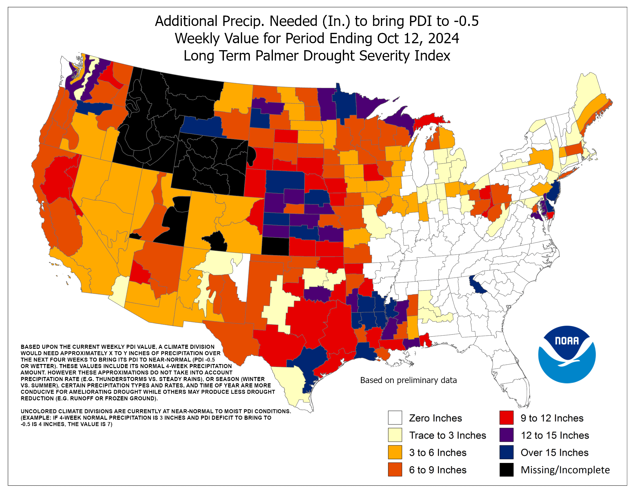
There is one product, based on the Palmer Hydrological Drought Index, that attempts to answer this question from the Climate Prediction Center. However, I would treat it as an estimate. Even so, it gives you an idea of how far we have to go for a recovery. They estimate that we would have needed 9 to 15 inches of rain across much of Illinois to end the drought. That is a tall order. The wettest July on record for Illinois is 8.03 inches in 1958 and the wettest August on record was 6.91 inches in 1977.
Personally, I’m not sure it would take record-breaking rainfall. And I’m not sure we want 9 to 15 inches over the course of one or two months because that could lead to all kinds of other problems like flooding and heavy soil erosion.
Based on past droughts in Illinois, a month with rainfall 50 percent above normal (around 6 inches) followed by several months with near-normal rainfall would be capable of turning things around without the more serious consequences of heavy rainfall.


