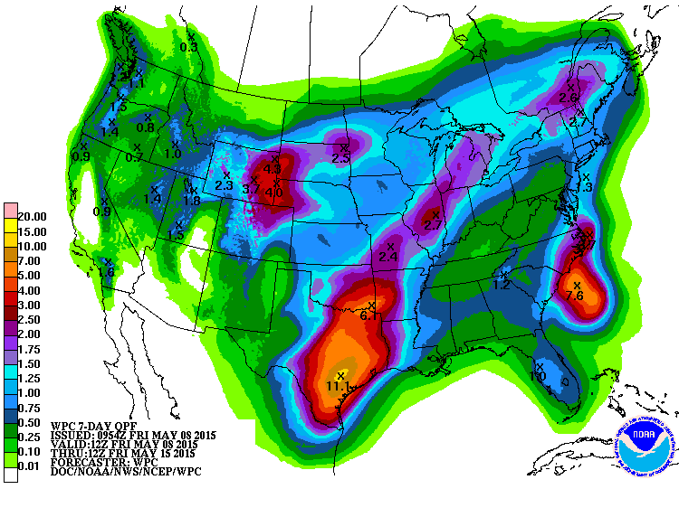
Here is the Qualitative Precipitation Forecast (QPF) for the next 7 days, according to the National Weather Service. This shows the potential amounts of rainfall, your mileage may vary. The area in shades of violet and purple are 1.5 to 2.5 inches. Shades of blue are 1 to 1.5 inches. Most of this is expected to fall in the next 3 days.
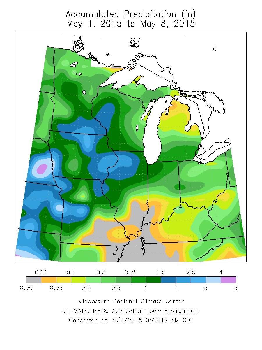
Here is how much rain has fallen so far in May across the Midwest.
NOAA has released a new 2-page fact sheet on El Niño and the Midwest (links below). Several people in the Midwest had input into this, including myself. El Niño typically results in warmer and drier than average winters. Confidence in these patterns is higher during stronger El Niño events.
Right now the NOAA Climate Prediction Center states that El Niño is favored to begin in the next 1-2 months and last into spring of 2015. The current thinking is that the odds are 2-in-3 in favor of it arriving and that the event will likely remain weak throughout its duration.
The NWS Climate Prediction Center has released the new outlooks for March as well as March-May.
One of the key things to come into play is the status of La Niña in the Pacific Ocean. A La Niña event occurs when ocean temperatures are colder-than-normal along the eastern part of the Pacific Ocean basin. The associated ocean and atmospheric pattern tends to give us a wet spring in states along the Ohio River Valley. CPC states that “La Niña is likely to transition to ENSO-neutral conditions during March-May 2012.”That’s government-talk for saying that the La Niña event is fading fast and will be gone before the end of spring.
The outlook for March in Illinois calls for an increased chance of above-normal temperatures and above-normal precipitation. The outlook for March-May calls for an increased chance of above-normal temperatures throughout the state. However, it shows an increased chance of above-normal precipitation in the eastern half of the state while the western half has “equal chances” of above-, below-, near-normal precipitation.
The new outlook for June-August (maps below), the heart of the growing season, is for an increased chance of above-normal temperatures in southern Illinois and “equal chances” for the rest of the state. The entire state is in “equal chances” with respect to precipitation.
Just a note on “equal chances”. That’s the NWS way of saying that none of their forecasting techniques are indicating a higher risk of unusual temperature or precipitation patterns. NWS Climate Prediction Center outlooks. Click to enlarge. Click to enlarge. Click to enlarge.
NOAA’s Climate Prediction Center has come out with a new forecast for December and for December-February (winter). This is part of their routine update cycle.
December
The outlook for December in Illinois calls for an increased chance of above normal temperatures. An increased chance of above normal temperatures translates into just a few degrees above normal. Temperatures in Illinois have run an average of 2.9 degrees above normal for every month since March of this year. Therefore, continuing with a forecast for above-normal temperatures is not surprising.
The outlook calls for equal chances of above, below, or near-normal precipitation (or equal chances as they call it) in December in Illinois.
December-February (winter)
The outlook for December-February remains the same as last month. There is an increased chance of above-normal precipitation for all of Illinois. And, there is an increased chance of above-normal temperatures for the southern two-thirds of the state. See the figure below for more details. NOAA's Climate Prediction Center forecast for December and December-February (click to enlarge).