Rainfall and Temperatures Across the Midwest in August

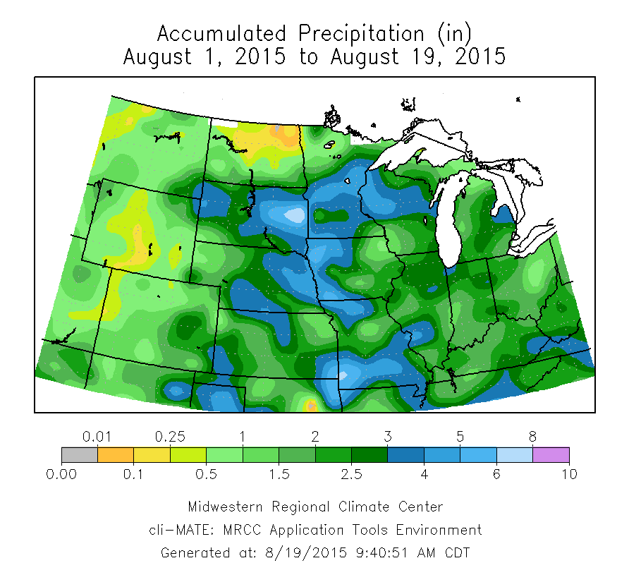
Here is a snapshot of conditions across the Midwest for August. The first map shows the actual precipitation, the second the departures from average, and the third shows the temperature departures from average. Overall, the region has been wet with temperatures close to average for August.

For Illinois, the statewide average  is 1.8 inches, which is about 20 percent below average. The heaviest amounts of 3 to 5 inches have been just east of St. Louis August. Meanwhile, widespread areas in Missouri, Iowa, Minnesota, Kansas, Nebraska, South Dakota, and Wisconsin, have reported 3 to 6 inches of rain. It has been less wet in the eastern Corn Belt.

map1

Continue reading “Rainfall and Temperatures Across the Midwest in August”
Most of Corn Belt Soaked in July

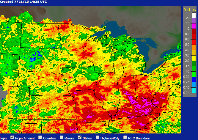
Here is the latest radar/raingauge estimated rainfall totals for July across the Midwest through this morning.

Much of the Corn Belt has been extremely wet. Heavy rains amounts of 5 to 10 inches are found across Minnesota, Wisconsin, Missouri, southern Iowa, Illinois, Indiana, Ohio, and Kentucky for July. Even portions of the Plains states received 2 to 5 inches of rain, which is well above their typically dry July.

For Illinois, amounts of 5 to 10 inches are found between East St. Louis, Moline, and eastward, as well as south of Carbondale and parts of northeast Illinois. Most of the rest of the state has received 2 to 5 inches. There are even a few small areas with less than 2 inches of rain in southern Illinois and the northwest corner.

July Rainfall. Click to enlarge.
July Rainfall. Click to enlarge. Areas shaded in red and purple have between 5 and 10 inches of rain. Areas in yellow and orange are 2 to 5 inches, and areas in green are less than 2 inches.

Continue reading “Most of Corn Belt Soaked in July”

El Nino and the Latest NWS Outlook for Summer, Fall, and Winter

Summary: According to the NWS Climate Prediction Center, El Niño has arrived and has a 90% chance of staying this summer and an 80% chance of remaining through the end of 2015. In terms of strength, this El Niño is expected to be weak to moderate. Illinois is expected to have an increased chance of cooler-than-average conditions in the late summer and on into fall.

The El Niño event has finally arrived and heavily influenced the NWS climate outlooks released this morning. For June (first figure, top row), the Southern Plains are expected to have an increased chance of cooler-than-average temperatures. A large part of the US is expected to have an increased chance of wetter-than-average precipitation, including the southern two-thirds of Illinois.

For the period June-August (first figure, second row), the increased chance for cooler-than-average conditions stretches northward and eastward and includes far western Illinois. The  increased chance for wetter-than-average conditions does not cover Illinois. This should not be a concern since no part of Illinois is in drought now.

Later forecasts for July-September, August-October, and September-November show in increased chance of cooler-than-average across Illinois (see second figure for the July-September temperatures). Continue reading “El Nino and the Latest NWS Outlook for Summer, Fall, and Winter”

2014 – 15th Coldest in the Corn Belt

In a earlier post I compared how Illinois temperatures compared to the rest of the world in 2014. Over at the Sustainable Corn blog, I posted some more thoughts on how the Corn Belt just came off the 15th coldest year on record, while the rest of the world was the warmest on record. You would have to go back to 1996 for a colder year, and before that 1978 and 1979. Here is the time series plot for annual temperature for the Corn Belt. See the Sustainable Corn blog post for more.

map1

One thing I forgot to emphasize in the Illinois post was that, according to Climate.gov, 19 out of the last 20 years have been the warmest on record for the world. That is an impressive streak.

One last thought – 2014 was very unusual year for Illinois compared to both our historical temperatures and what happened around the world. The chances of a repeat in 2015 are very slim.