The preliminary numbers are in – the statewide temperature for March of this year was 34.1 degrees. That is 7 degrees below the long-term average of 41.1 degrees and the 11th coldest March on record. That is in remarkable contrast to March 2012, which ended up at 55.3 degrees. That March was 14.2 degrees above the long-term average and the warmest March on record. In fact, the difference between this March and last March was a whopping 21.2 degrees.
The statewide precipitation was 2.85 inches, which is 0.15 inches below the long-term average of 3.00 inches. Precipitation amounts were largest just east of St. Louis and lightest in east-central Illinois. The largest monthly total came from Kaskaskia with 6.42 inches of precipitation. Several surrounding sites had in excess of 5 inches.
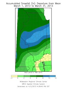
[updated 4/11/13] Snowfall was above-average for the month thanks mostly to a large storm that passed through central Illinois on March 24-25 and some earlier events that passed through northern and western Illinois. The Springfield COOP site received 17 inches in 24 hours, a new 24-hour record for that site, and a storm total of 18.5 inches. They finished the month with 19.6 inches of snow. The CoCoRaHS site at Nokomis (IL-MY-1), to the south of Springfield, had a similar experience with 19 inches of snow from the one storm and a monthly total that tied Springfield with 19.6 inches. A CoCoRaHS site at Springfield (IL-SG-17) reported 18 inches during the one storm and a monthly total of 19.5 inches.
Precipitation totals and departures from the long-term average for March:


Snowfall totals and departures from the long-term average for March:


January Climate Stats
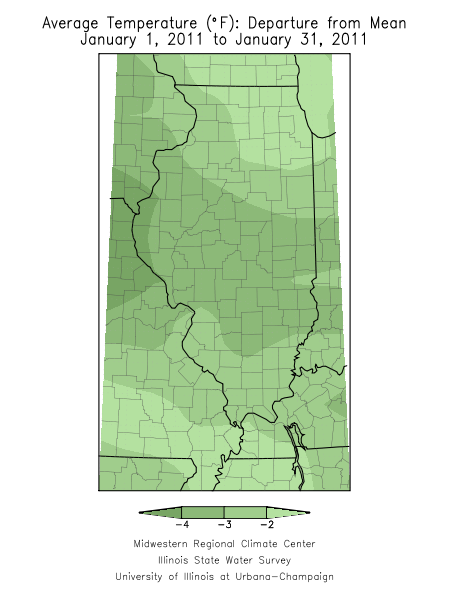
The average statewide temperature for January in Illinois was 21.8 degrees, 3 degrees below normal. That’s warmer than last January when the statewide temperature was only 20.3 degrees and a far cry from the record low January of 1977 when the average temperature was only 10.3 degrees.
The warmest temperature of the month was in Cairo with 67 degrees on January 1. The coldest temperature of the month was in Mt. Carroll with -20 degrees on January 21.
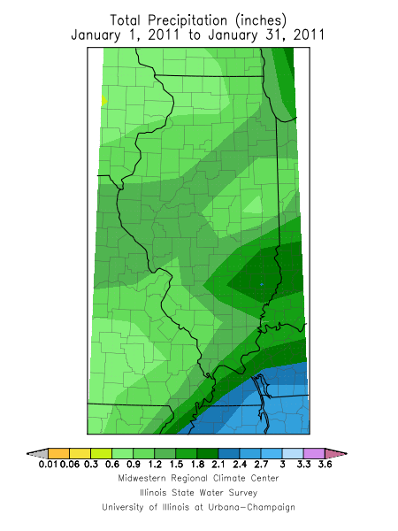
Snowfall was close to normal across much of the state. Amounts ranged from 4 inches in far southern Illinois to over 12 inches in parts of western and northeastern Illinois. Spring Grove, along the Illinois-Wisconsin border, reported the largest snowfall amount in the state with 15.1 inches.
While snowfall was close to normal in most areas, the statewide precipitation (rainfall + water content of snow) was only 1.23 inches, 0.7 inches below normal. Olney reported the largest monthly precipitation amount in the state with 2.81 inches.
Update: added maps for January snowfall, precipitation and temperature departures on February 4.


First Half of January – Slightly Colder than Normal
The Illinois statewide average temperature for January 1-15, 2010, was 21.5 degrees, 2.3 degrees below normal. The statewide average precipitation for the same period was 0.75 inches, 84 percent of normal. Precipitation includes both rainfall and the water content of any snowfall.
After a very active December in terms of snowfall, January has been relatively quiet so far. The only significant snowfall totals are in western Illinois and along Lake Michigan. However, the persistently cold weather means the snow has stuck around.

December 2010 in Illinois – Cold and Snowy
December 2010 in Illinois turned out to be one of the coldest and snowiest on record. I updated the numbers on January 3 and the maps on January 5.
Temperature
The average statewide temperature was 24.0 degrees, 5.8 degrees below normal and the 12th coldest on record, based on preliminary data.
Snowfall
Snowfall was above-normal throughout the state in December and heaviest in a band from northwest Illinois into east-central Illinois (see maps below). Snowfall totals for December include 20.4 inches in Champaign-Urbana (snowiest December on record), 18.1 inches in Bloomington-Normal(second snowiest December on record), and 19.2 inches in Peoria (third snowiest December on record). Champaign-Urbana beat both Rockford (19.2 inches) and Chicago O’Hare Airport (16.2 inches) on snowfall totals. The largest snowfall total reported in the state was 30.0 inches near Galena by a CoCoRaHS observer. Streator reported 28.5 inches, the highest amount from a NWS cooperative observer.
Precipitation
Even though snowfall was above average in most locations, the average statewide precipitation was 1.8 inches, 0.9 inch below normal. Some of the snowfall did not have a high water content, especially if it fell when the temperatures were in the 20s. While the rule of thumb is that 10 inches of snow equals 1 inch of water, a 10 to 1 ratio, I have seen ratios ranging from 4 to 1 to 22 to 1 in Illinois.


