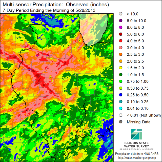
More rain fell over Illinois over the Memorial Day weekend. The heaviest amounts were in the central part of the state and ranged from 2 to 6 inches (yellow to dark red in the map below).
Right now the statewide average rainfall for May stands at 5.03 inches, based on preliminary data. More rain is forecasted for today and much of this week. So this total is likely to increase as we go through the week. By contrast, Illinois received only 2.5 inches in May 2012.

A Warm Fall for Illinois?
NOAA’s Climate Prediction Center released their latest monthly and seasonal outlooks today (Thursday). In the figure below, the outlook for October in Illinois is for an increased risk of above-normal temperatures and below-normal precipitation. The 3-month outlook for October-December in Illinois is for an increased risk of above-normal temperatures. Their precipitation outlook is neutral at this time.
That’s not the best news for drought recovery but it might make it easier on farmers for fall harvest.
One factor that could come into play this winter is El Niño. In fact, the CPC says an El Niño event is likely to arrive some time in September, according to their latest advisory. However, in the last two winters the Arctic Oscillation has played a major role in our winter weather. Two winters ago it was in the negative phase and dumped lots of cold air into Illinois. Last winter it was in the positive phase and prevented a lot of cold air from reaching us. Unfortunately, we can only forecast the Arctic Oscillation out to 14 days.

Drought Eases Slightly in Illinois
Drought eases slightly in Illinois thanks to the rainfall and cooler temperatures of the last few weeks. The US Drought Monitor for August 28 shows improvement in northeast Illinois, especially Cook County.
While not yet reflected in the Drought Monitor, August has been a better month than July with more rain and milder temperatures. I’ll post the end of the month stuff on Friday. In the meantime, here are the latest departures from normal for the month so far (second figure). Parts of western and central Illinois as well as much of Illinois north of Interstate 80 have been below normal, areas in east-central and southern Illinois received above-normal precipitation for the month.
Of course, the real game-changer is yet to come – Tropical Storm Isaac. More on that later.


2nd Wettest June on Record
Illinois has experienced the 2nd wettest June on record, based on preliminary records through June 30. The statewide average rainfall was 7.8 inches, 3.7 inches above normal. The wettest June on record was 1902 with 8.37 inches. The rains over the weekend, especially north of I-80 and along I-70 caused this June to move up from fourth to second wettest June on record. Statewide records extend back to 1895. This number is provisional and may change slightly as more data comes in.
The larger rainfall totals occurred in the northern two-thirds of the state where amounts of 7 to 12 inches were common. Meanwhile far southern Illinois remains closer to normal with amounts ranging from 3 to 6 inches.

