New Weather Outlook for June

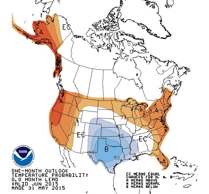
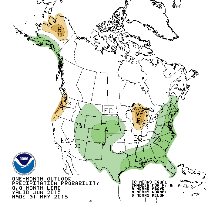
The NWS Climate Prediction Center released their updated outlook for June, 2015. The new June outlook shows northern Illinois, including the Chicago area, with an increased chance of warmer and drier than average conditions.

Much of central and southern Illinois has equal chances (EC) of above, below, and near-average temperature and precipitation. This is different from the previous outlook for June that was released mid-May. That one had central and southern Illinois with an increased chance of wetter than average conditions.

While these outlooks cover the entire month, most of the model forecast skill is in the first 10 days. So the features of warmer and drier conditions in northern Illinois may be more in line with what’s expected in the first week or two and less with the entire month.  More useful information can be obtained from the NWS 6-10 and 8-14 day forecasts which are updated daily.

off15_temp
Temperature forecast for June. Click to enlarge.
off15_prcp
Precipitation forecast for June. Click to enlarge.

February – 7th Coldest on Record for Illinois

The statewide average temperature for February was 18.6 degrees. That is 12.3 degrees below the 1981-2010 average and the 7th coldest February on record. By comparison, February 2014 was 9th coldest at 19.5 degrees.

Here are some amazing statistics for Chicago. February was tied with 1875 for the coldest on record, according to the Chicago National Weather Service.  The average temperature for February was 14.6 degrees, 13.1 degrees below average. In addition, it was the 10th coldest month overall on record. February snowfall in Chicago was the third largest on record with 26.8 inches, 17.7 inches above average.

Snowfall for February in Illinois was widespread and well above average. Amounts of 15 to 20 inches were common in western and northern Illinois and 10 to 15 across central Illinois and parts of far southern Illinois. This was 8 to 12 inches above average in many locations. See maps below. Click to enlarge.

Some other February snowfall totals from around the state:

  • Chicago Midway AP: 28.3 inches
  • Rockford: 14.7 inches
  • Peoria: 12.8 inches
  • Quincy Lock and Dam: 11.2 inches
  • Springfield: 22.6 inches
  • Champaign-Urbana: 12.4 inches
  • Bloomington-Normal: 13.0 inches
  • Carbondale: 6.0 inches

The statewide average precipitation (rain plus the water content of snow) for February was 1.5 inches, 0.5 inches below average. Most of the state received 1 to 2 inches of precipitation, except for far southern Illinois which got 2 to 3 inches. See the second batch of maps for precipitation and precipitation departures from average.

Continue reading “February – 7th Coldest on Record for Illinois”

Quiet Winter for Snowfall across central US

Snowfall across the central US has been slightly below average so far this winter and stands in stark contrast to last winter. However, the impact on soil moisture, rivers, and streams has been minimal.

Here is an example of snowfall differences. At Chicago O’Hare airport the snowfall total for this winter through January 14 is 13.7 inches. Last year through this date it was 35.0 inches and the 1981-2010 average is 14.2 inches.

In the first map are the snowfall departures for this winter. All the areas in tan or beige are up to 10 inches below average. That includes almost all of Illinois, Minnesota, Iowa, Missouri, Indiana, and Kentucky, as well as large portions of the Dakotas, Nebraska, Kansas, Wisconsin, Michigan, and Ohio. Areas in green are above average and include a small area in far southern Illinois and another around Moline. Snowfall is above average across upper Wisconsin and the Michigan UP.  Continue reading “Quiet Winter for Snowfall across central US”

Friday Wrapup – Illinois Very Cold and Dry in November

snow-nov21So far, November has been much colder and drier than average. The statewide average temperature is 34.6 degrees, which is 9 degrees below average.

The statewide average precipitation (rainfall + water content of snow) was only 0.6 inches, about a third of the average through this date.

There have been astounding snowfall totals in places like Buffalo, NY, and some significant snowfall in Minnesota and Wisconsin. However, Illinois and most of the surrounding states have had far less snowfall (first map) in November. Many sites in the state had 1 to 2 inches except for a stretch between Quincy and Chicago with less than an inch.

The modest snowfall totals in November so far are not that unusual. Average snowfall totals for the month are generally less than an inch south of I-80 and about 1 to 2 inches north of I-80 (second map).

map2Illinois-snow-11NOV-normals