April Showers Finally Arrive

Temperature

Some much-needed rain arrived in Illinois over the weekend. As the first map below shows, the rains were widespread across the state. The heaviest amounts of two inches or more fell in the area from around St. Louis eastward and another band across northern Illinois.
However, rainfall in some key agriculture areas of the state remains below normal for April (second map). A band through north-central Illinois is running about 1 to 2 inches below normal for the month. Another area of dry conditions can be seen in southern Illinois  in the counties along the Ohio River. This area of dryness is connected to a larger region in southeast MO, western KY, and southern IN.

Precipitation

The statewide average temperature for the first half of April is 54.5 degrees, 5.7 degrees above normal. As noted in earlier posts, despite the warm weather we have had several days with below freezing temperatures. Considering that many plants in the landscape are about 3 to 4 weeks ahead of schedule, the freezing temperatures did cause some damage. In my yard, the list of damage included some hostas, a smoke bush, and the tips of some rose bushes and yews – all cosmetic.

Severe Weather

At least Illinois has avoided the severe weather so far in April. No tornadoes were reported  as of April 16, unlike the states to our west. The tornado count in Illinois for 2012 is 2 for January, 4 for February, and 8 for March.

Seven-day precipitation for Illinois, ending April 16, based on radar data from the NWS.

Precipitation departures from normal for April 2012, based on radar data from NWS.

Record-Setting April Rainfall in Illinois

Record-Setting Rainfall

[Updated May 2]
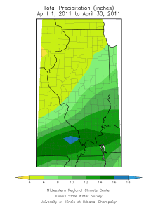
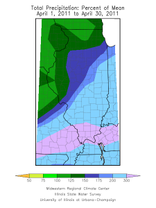
Based on preliminary data, the statewide average rainfall for April (as of May 2) is 7.59 inches, beating the old record of 7.13 inches set in 1957. Statewide records go back to 1895.

Rain, April 2011 (click to enlarge).

Rain, percent of average, for April 2011 (click to enlarge).

Selected Rainfall Totals

April rainfall has been heaviest in southern Illinois with several stations reporting over 10 inches of rain. Here are the rainfall totals through April 30 across the state, ranked from high to low. These are provisional and may change as more data comes in and as the data are processed through quality control at the national archive.

16.90 DU QUOIN 4 SE
15.29 BROOKPORT DAM 52
15.13 CAIRO 3 N
15.10 SMITHLAND L&D
15.04 MURPHYSBORO 2 SW
14.84 CARBONDALE SEWAGE PLT
13.94 CHESTER
13.92 GRAND CHAIN DAM 53
13.74 HUTSONVILLE PWR PL
13.68 CENTRALIA
13.31 OLNEY 2S
13.18 ROBINSON
12.97 SHAWNEETOWN OLD TOWN
12.56 LAWRENCEVILLE
12.53 MT VERNON 3 NE
12.40 PALESTINE 2W
12.15 MT CARMEL
11.92 KASKASKIA RIV NAV LO
11.91 PINCKNEYVILLE 2 N
11.87 CLAY CITY 6 SSE
11.78 CASEY
11.71 KINMUNDY
11.67 HIDALGO 3SW
11.66 MARTINSVILLE 10S
11.37 BEECHER CITY
11.12 EFFINGHAM SE
11.06 NEW ATHENS
11.04 FAIRFIELD RADIO WFIW
10.98 NEOGA
10.67 IUKA
10.54 EFFINGHAM
10.49 FLORA
10.47 SALEM
10.32 GRAYVILLE
10.29 PARIS WTR WKS
10.23 MATTOON
10.22 SULLIVAN
10.22 VANDALIA
10.19 RAMSEY
10.08 NASHVILLE 1 E
9.81 CHARLESTON
9.60 NEOGA 4NW
9.25 ST DAVID
9.07 FISHER
9.01 RANTOUL
9.01 GREENVILLE
9.00 SHELBYVILLE DAM
8.97 CARLYLE RSVR
8.73 WINDSOR
8.70 LEBANON
8.55 PRAIRIE DU ROCHER
8.49 HIGHLAND
8.40 TRIMBLE 1E
8.32 PANA
8.17 DANVILLE SEWAGE PLAN
8.02 TUSCOLA
7.94 EDWARDSVILLE 2 W
7.91 MT OLIVE 1 E
7.91 BELLEVILLE SIU RSRCH
7.87 TAYLORVILLE
7.81 ALTON MELVIN PRICE
7.72 DANVILLE
7.72 HOOPESTON 1 NE
7.66 PEORIA 5NW
7.59 ARTHUR 1W
7.50 GERMANTOWN HILLS
7.44 NEWMAN 3W
7.42 URBANA
7.38 PAXTON
7.35 BOURBONNAIS 3 NW
7.33 PEORIA GTR PEORIA AP
7.33 SIDELL 5 NW
7.32 ST ANNE
7.27 HAVANA
7.21 MOWEAQUA 2S
7.11 PHILO
7.10 DECATUR
7.08 LOVINGTON
7.02 OGDEN
6.95 MORRISONVILLE
6.94 MILFORD 5 NW
6.85 WATSEKA 2 NW
6.70 CLINTON 1 SSW
6.65 DAHINDA
6.52 SAYBROOK 2N
6.42 STREATOR
6.38 PARK FOREST
6.32 KINCAID
6.30 MARSEILLES LOCK
6.29 JERSEYVILLE 2 SW
6.27 CAMP GROVE
6.27 SHERMAN 1 ESE
6.24 CHANNAHON DRESDEN ISLAND
6.22 OTTAWA
6.19 DWIGHT
6.18 SPRINGFIELD #2
6.16 CHENOA
6.15 STANFORD 2S
6.08 PRINCEVILLE 2W
6.08 KEWANEE 1 E
6.04 BLOOMINGTON 5W
6.02 ROMEOVILLE LEWIS UNIV AP
6.02 PONTIAC
6.00 SPARLAND 6 SW
5.96 LANSING
5.95 LITTLE RED SCHOOL HSE
5.91 NEWARK 2 SSE
5.86 ELBURN
5.86 LA GRANGE
5.84 KNOXVILLE
5.83 FARMER CITY 3W
5.81 MASON CITY
5.73 CHICAGO MIDWAY AP 3 SW
5.73 ROANOKE
5.70 YORKVILLE 3 SW
5.65 ST CHARLES 7 NW
5.62 ELGIN
5.62 BRADFORD 3SSE
5.60 ELIZABETH
5.57 MUNDELEIN 4 WSW
5.55 MORTON
5.50 JOLIET BRANDON RD DM
5.49 NORMAL 4NE
5.49 NORMAL 4NE
5.46 SPRINGFIELD CAPITAL AP
5.45 PERU
5.45 PERU
5.45 MINONK
5.42 ALTONA
5.36 CARLINVILLE
5.35 EARLVILLE 3 S
5.35 MORRIS
5.33 CHICAGO BOTANICAL GARDEN
5.32 MENDOTA 2 SE
5.32 OAK BROOK 2W
5.32 JACKSONVILLE 2
5.31 SPRING GROVE
5.30 CHATSWORTH
5.30 WINCHESTER
5.28 EUREKA
5.25 PLAINFIELD 3 NE
5.22 LINCOLN
5.21 ALBERS 1 W
5.16 WOODSTOCK 5 NW
5.13 STREAMWOOD
5.08 BARRINGTON 3 SW
5.08 GLEN ELLYN 4 S
5.06 JACKSONVILLE 2 E
5.04 MOLINE QUAD CITY INTL AP
5.01 PRAIRIE CITY 2S
5.01 CONGERVILLE 2 NW
4.99 LAKE SPRINGFIELD
4.90 CHICAGO OHARE INTL AP
4.88 MCHENRY STRATTON L&D
4.87 VIRGINIA
4.80 MACKINAW
4.78 PITTSFIELD #2
4.78 CHICAGO MIDWAY AP
4.73 MORRISON
4.73 BLOOMINGTON WATRWRKS
4.68 BUFFALO
4.65 QUINCY DAM 21
4.63 WHITE HALL 1 E
4.57 RIPLEY
4.54 FAIRBURY WWTP
4.54 FREEPORT WWP
4.51 TOULON
4.44 AUGUSTA
4.41 DE KALB
4.35 MT PULASKI
4.35 GREENFIELD
4.34 HARVARD
4.33 ATHENS 2 N
4.30 STEWARD 3S
4.25 GENOA 2 SW
4.24 KANKAKEE METRO WWTP
4.21 CISCO
4.20 ROCHELLE
4.20 ROCHELLE
4.18 RUSHVILLE
4.16 ALEDO
4.14 GALESBURG
4.11 SHABBONA 3S
4.11 QUINCY RGNL AP
4.04 PERRY 6 NW
3.98 BELVIDERE
3.97 MONEE RSVR
3.94 BENTLEY
3.91 ROSCOE 2 SE
3.71 STOCKTON 3 NNE
3.66 BEARDSTOWN
3.65 AMBOY
3.62 PAW PAW
3.61 MT CARROLL
3.47 WHEATON 3 SE
3.45 MARENGO
3.40 ROCKFORD GTR ROCKFORD AP
3.20 GRIGGSVILLE
2.61 MONMOUTH 4 NW

First Half of April in Illinois – Warm

Based on preliminary numbers, the statewide average temperature for the first half of April is 54.0 degrees, 5.4 degrees above the 1971-2000 average.
The statewide average rainfall for the first half of April is 1.65 inches, 0.22 inches below average. Rainfall ranged from under an inch in far northern Illinois to over 2 inches in far southern Illinois (see map).

April rainfall
Rainfall for April 1-15, 2011, for Illinois.

Warmest April on Record for Illinois

Based on preliminary data, the statewide average temperature for Illinois in April was 58.4 degrees, 6.2 degrees above normal and the warmest April on record. This beats the old record of 58.2 degrees set in 1955. Official statewide average temperature records go back to 1895. The warm temperatures in April were not unique to Illinois – the entire Midwest was much above normal (see map below).
April rainfall was 3.5 inches, just 0.3 inches below normal. Areas in western Illinois around received the most precipitation, over 5 inches in some locations. A CoCoRaHS observer in Matherville (Mercer County) reported 6.50 inches for the month.

April temperature departures
Temperature departures for April across the Midwest (click to enlarge).

Midwest precipitation for April
Precipitation totals for April across the Midwest (click to enlarge).