

Tornado risk has been on a lot of minds after the events in Moore, OK. For the first time that I can recall, the local TV station (Champaign) ran an advertisement for pre-constructed storm shelters.
In 2011, we produced county-level tornado track maps for all counties in Illinois to measure the historical risk of tornadoes across the state. These maps were based on data from the NOAA Storm Prediction Center for the period of 1950 to 2010. For example, below is the map for Cook County that shows tornado tracks and touchdowns, color-coded by (E)F-scale.
To me, the strongest reminder that a strong tornado can pass through Chicago is the April 21, 1967, Oak Lawn F-4 event that killed 33 and injured 500. Here are some pictures of from the Oak Lawn Public Library of that event that look a lot like the damage in Moore, OK.
You can see the rest of the maps on the Tornado Maps page at the Illinois state climatologist website.

60th Anniversary of the First Tornado Detected by Radar
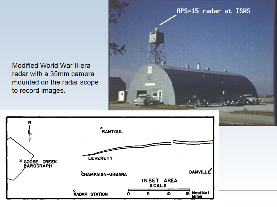
Today is the 60th anniversary of the first documented case of a tornado detected by radar. Water Survey staff, at Willard Airport in Champaign, IL, captured the historic event on film on April 9, 1953. This discovery helped lead to the first national weather radar network in the United States.
The radar was located at Willard Airport, south of Champaign IL, and was being used along with a rain gauge network to relate radar signals with rain rates. Don Staggs, the radar technician, had stayed late to complete repairs on the radar. While testing the repairs, he noticed an interesting radar return and began recording the radar scope using the mounted 35 mm camera. As a result, he captured a well-defined hook echo on film. See photo below. The hook echo is best described by the National Severe Storm Laboratory:
A “hook echo” describes a pattern in radar reflectivity images that looks like a hook extending from the radar echo, usually in the right-rear part of the storm (relative to the motion of the storm). A hook is often associated with a mesocyclone and indicates favorable conditions for tornado formation. The hook is caused by the rear flank downdraft and is the result of precipitation wrapping around the back side of the updraft.
Afterwords, researchers related the radar data that Don recorded to detailed damage damage reports along the tornado’s path (see map and photos below).
I find this story fascinating for a variety of reasons. Some of the reasons are personal. It happened at my home institution (Illinois State Water Survey) and I knew several of the people involved (Don Staggs, Glen Stout, Floyd Huff, Stan Changnon). But beyond that there were several key ingredients to the story:
- The radar was on when it should have been off. If Don Staggs had not been working late to replace a piece of equipment on the radar, the discovery would have been missed. The storm occurred in the early evening hours when the radar was normally turned off. Don had the foresight to keep the radar running when he saw the unusual return on the radar.
- The tornado occurred near one of the few radars in the country at that time designed for weather research, as opposed to defense or air traffic control. There was no network of weather radars like we enjoy today. In addition, this radar set was equipped with a 35-mm camera to record what was on the scope.
- The thunderstorm was strong enough to produce a clear hook echo, and was located to the north of the radar so there was no attenuation (interference) from rain.
- The tornado was well-documented in terms of the location and timing of the damage. This allowed scientists to relate what happened on the radar scope with what happened on the ground.
The 1954 Water Survey report on the tornado stated, “It may be possible to establish radar storm warning systems in tornado areas to reduce loss of lives.” The April 9, 1953, event, along with subsequent events, helped provide the push in the US for developing a nationwide network of weather radars.

- First recorded radar hook echo that was later associated with a tornado, April 9, 1953, near Champaign, IL. Photo by Illinois State Water, Prairie Research Institute, University of Illinois.

Additional information on this event:
- Water Survey page on the hook echo event
- History of the CHILL radar
- 1954 Water Survey report on the event (pdf)
- Dr. Fujita’s 1958 Journal of Meteorology article
Tornado Drought
Tornado Drought in Illinois
One of the side effects of drought is that usually reduces the amount of severe weather we experience in Illinois. This year was a good example of this. After the deadly Harrisburg tornado on February 29, things have been relatively quiet. Here is the monthly breakdown of tornado reports in Illinois, as reported by the NOAA Storm Prediction Center:
- 2 in January
- 4 in February
- 8 in March
- 0 in April
- 8 in May
- 0 in June
- 1 in July
- 23 total by the end of July

Tornado Drought in the US
Harold Brooks of NOAA wrote about the US tornado drought on his blog. Here is the figure he used in his post for the US.

Deadly Tornado Strikes Harrisburg IL
Based on preliminary reports, six people were killed in Harrisburg (southeastern Illinois), when a tornado struck late last night. The NWS is surveying the damage today. I will post more information when it becomes available.
Update 9:30 pm, March 1. I have updated the numbers below to reflect the addition of 2011 data.
Update 8:30 am, March 1. The Paducah NWS office has released a preliminary report on the tornado outbreak in southern Illinois, Indiana, and Kentucky.
Update 3:45 pm, February 29. According to a news conference aired on WSIL-TV, the NWS has identified this as an EF-4 tornado with wind speeds up to 170 mph. Wind speeds are estimated from the level of devastation at the scene in Harrisburg. EF-4 tornadoes are relatively rare in Illinois. Out of 2244 2322 tornadoes reported in Illinois between 1950 and 2010 2011, only 40 were in this category. However, they are very deadly. Of the 203 deaths related from tornadoes between 1950-20102011, 100 of these came from EF-4 tornadoes. That is 49 percent of the data with an average rate of 2.5 deaths per EF-4 event.
Tornadoes are more common in spring and summer, but they can occur in February. A total of 29 39 tornadoes occurred in February from 1950 to 2010 2011, causing 6 deaths and 28 serious injuries. We have a complete analysis of Illinois tornadoes here, including plots and maps. As the map below shows, many of our February tornadoes occur in the southern part of the state.
.")