

 For much of Illinois April is typically the last month that we see freezing temperatures until Fall (at least we hope). Below are the maps showing the median dates when we see 28 and 32 degrees for the last time in Spring. The median represents the middle value in the range of dates and is less sensitive than the average to unusually early or late dates.
We have more discussion and maps, including the earliest and latest dates of freezes during the 1981-2010 period on our frost webpage.
In addition you can track the status of this spring (2013) in terms of how things stand on hitting 28 and 32 degrees from the Midwestern Regional Climate Center.


Snowfall Map from the March 24-25 Snowstorm
Here is a great product from the NWS (www.srh.noaa.gov/ridge2/snow/) showing the snowfall totals of the last two days. I chose the last two days since some snow from the event fell before 7 am on Sunday. The heaviest amounts were concentrated over central Illinois, including 18.5 inches at Springfield. It was very impressive for a late season snowfall. NWS Lincoln has a listing of the snowfall totals from the storm.

Cold March
I dropped my car off at the shop for some brake work this morning here in Champaign and decided to walk to work. The air temperature was 21 degrees and the wind chill was 4 degrees. That was an uncomfortable stroll even with a winter coat, hat, and gloves. A year ago this morning (March 20, 2012), the air temperature was 63 degrees and well on its way up to a high of 82 degrees, a record high for this date.
So far this year, the statewide March temperature is 33.3 degrees. A year ago through this date, the statewide temperature was 51.1 degrees. That’s a whopping 17.8 degree difference. March went on to become the warmest March on record at 55.3 degrees, 14.2 degrees above the long-term average monthly March temperature of 41.1 degrees.
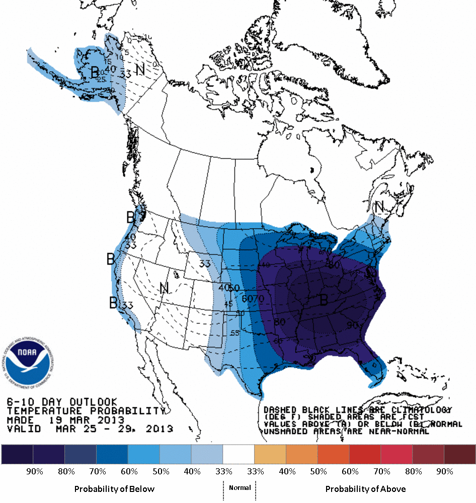
The rest of March does not look promising. The 1-5 day forecast shows temperature 10 to 14 degrees below average for Illinois. The 6-10 and 8-14 day forecast show widespread cold weather across Illinois and the central US. Figures below.
The long-term average temperatures for March were calculated from the 1981-2010 period.


Spring Frost in Illinois
Frost in spring is a concern to farmers, landscapers, and gardeners. Frost in Illinois is usually not measured directly at weather stations. Instead, it is inferred from the air temperature – when the air temperature crosses the threshold of 32°F.
The average date of the last spring occurrence of 32°F ranges from April 7 in far southwestern Illinois to April 28 in northern Illinois (see map below). The actual date can vary from year to year. The spring dates are getting earlier by about 5-10 days over the last few decades.
The actual date varies from year to year. For tender plants, add two weeks to the average date in the spring to protect against late season frost.
Although 32°F is the temperature traditionally used to show frost, visible frost can be seen on the ground and objects when temperatures are slightly above 32°F on calm, clear nights that allow cold, dense air to collect near the ground. Under these conditions, the temperature near the ground actually can be a few degrees cooler than at the 5-foot height of the official National Weather Service thermometer.
Open, grassy areas are usually the first to experience frost, while areas under trees are more protected because the trees help prevent the heat from escaping. Homeowners can protect tender plants by providing this same type of protection if they cover their plants when a frost is expected. Plants near heated buildings sometimes are spared too. Because of the abundance of warm buildings and trees in towns, they tend to experience frost less often than those living in the country.
