

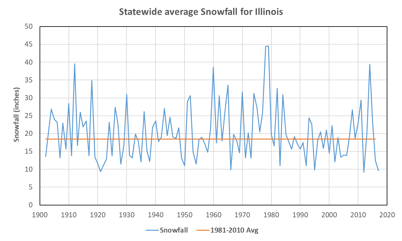
The snowiest winter on record was 1978-79 with a statewide total of 44.5 inches. The winter of 2011-12 had the least amount of snow with a statewide total of 9.2 inches.
While a few stations recorded snowfall in the 1800s, our statewide snowfall records in Illinois began in 1902. There is no long-term trend in the snowfall totals; however, some decades were snowier than others, such as the 1910s, 1960s, and 1970s. In fact, the 1970s were the snowiest decade on record with an average snowfall of 27.2 inches.
Since the 1970s, snowfall amounts dropped steeply with less year to year variability for much of the 1980s and into the early 2000s. However, snowfall amounts in the last six winters have been more variable with the winter of 2013-14 being about as snowy as the late 1970s while the winters of 2011-12 and 2016-17 had the lowest and third lowest snowfall totals, respectively, for the state.
Continue reading “Snowfall Changes Over Time in Illinois”
Snowfall Changes Over Time in Illinois
The snowiest winter on record was 1978-79 with a statewide total of 44.5 inches. The winter of 2011-12 had the least amount of snow with a statewide total of 9.2 inches.
While a few stations recorded snowfall in the 1800s, our statewide snowfall records in Illinois began in 1902. There is no long-term trend in the snowfall totals; however, some decades were snowier than others, such as the 1910s, 1960s, and 1970s. In fact, the 1970s were the snowiest decade on record with an average snowfall of 27.2 inches.
Since the 1970s, snowfall amounts dropped steeply with less year to year variability for much of the 1980s and into the early 2000s. However, snowfall amounts in the last six winters have been more variable with the winter of 2013-14 being about as snowy as the late 1970s while the winters of 2011-12 and 2016-17 had the lowest and third lowest snowfall totals, respectively, for the state.
Continue reading “Snowfall Changes Over Time in Illinois”
Snow – Date of First Snowfall and Normals for Illinois
Date of First Snowfall
Here are the median dates of the first measurable snowfall of the season in Illinois. This map is based on 1971-2000 data. While it is not based on the current 1981-2010 averages, the map is still relevant for the purpose of getting an idea of the dates. Measurable snowfall means at least a tenth of an inch.
In the northern third of Illinois, the first snowfall usually occurs around Thanksgiving. The dates move from November to December once you reach central Illinois (just north of a line between Quincy and Champaign). By the time you reach Carbondale, the date can be as late as December 20.

Continue reading “Snow – Date of First Snowfall and Normals for Illinois”
Snow – Date of First Snowfall and Normals for Illinois
Date of First Snowfall
Here are the median dates of the first measurable snowfall of the season in Illinois. This map is based on 1971-2000 data. While it is not based on the current 1981-2010 averages, the map is still relevant for the purpose of getting an idea of the dates. Measurable snowfall means at least a tenth of an inch.
In the northern third of Illinois, the first snowfall usually occurs around Thanksgiving. The dates move from November to December once you reach central Illinois (just north of a line between Quincy and Champaign). By the time you reach Carbondale, the date can be as late as December 20.
Continue reading “Snow – Date of First Snowfall and Normals for Illinois”