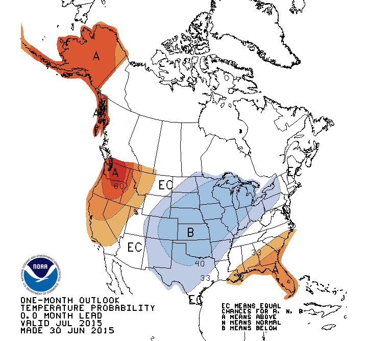
Illinois has an increased chance of below-average temperatures and above-average precipitation in July, according to the outlook released by the NWS Climate Prediction Center earlier this week.
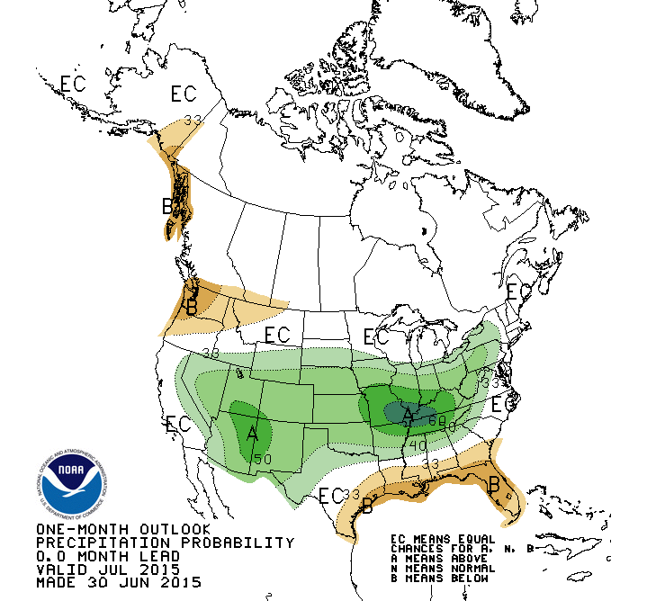
The July precipitation forecast is amazing for showing such a large area with an increased chance of above-average precipitation. The odds are especially high in southern Illinois. This does not necessarily mean that July will be record-breaking like June, just wetter than average.
Precipitation forecast for July. Click to enlarge.
The July temperature forecast shows a large area across the central US with an increased chance of below-average temperatures. Historically, it is not unusual in Illinois for wet conditions in May and June to lead to cooler temperatures in July. The wet soils keeps the air temperatures cooler. At least that’s the theory.
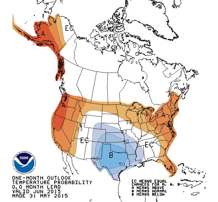
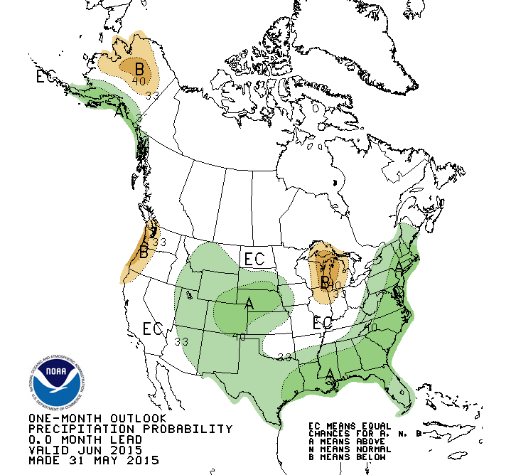
The NWS Climate Prediction Center released their updated outlook for June, 2015. The new June outlook shows northern Illinois, including the Chicago area, with an increased chance of warmer and drier than average conditions.
Much of central and southern Illinois has equal chances (EC) of above, below, and near-average temperature and precipitation. This is different from the previous outlook for June that was released mid-May. That one had central and southern Illinois with an increased chance of wetter than average conditions.
While these outlooks cover the entire month, most of the model forecast skill is in the first 10 days. So the features of warmer and drier conditions in northern Illinois may be more in line with what’s expected in the first week or two and less with the entire month. More useful information can be obtained from the NWS 6-10 and 8-14 day forecasts which are updated daily.
Temperature forecast for June. Click to enlarge.Precipitation forecast for June. Click to enlarge.
The Climate Prediction Center released their latest forecasts today (May 15) for June and this summer with cooler and wetter than average conditions expected in parts of Illinois.
The temperature forecast for June (Figure 1) in Illinois includes an area to the north of Interstate 74 with an increased chance of being cooler than average. This is part of a larger area of cooler conditions that runs across the northern states from the Rockies to the Appalachians. The rest of Illinois is labeled EC for equal chances of above, below, and near-average conditions – a neutral forecast.
Figure 1. June Temperature. Click to enlarge.
The precipitation forecast for June (Figure 2) in Illinois includes an area south of Interstate 74 with an increased chance of above average precipitation. BTW, while I used Interstate 74 as the dividing line, the forecast obviously is not that precise in terms of geography.
Figure 2. June Precipitation. Click to enlarge.
The temperature forecast for June-August (traditional summer) includes northern Illinois in an area with an increased chance of below-average temperatures along with states to the north. The rest of Illinois is labeled EC for equal chances (Figure 3).
Figure 3. Click to enlarge.
The precipitation forecast for June-August (traditional summer) has EC across Illinois and most of the Midwest (Figure 4).
Figure 4. Click to enlarge.
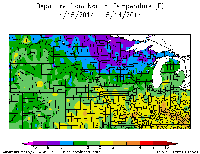
If the temperature pattern for June and June-August seems familiar, here is what we have experienced in the last 30-days for Illinois and the Midwest (Figure 5). Notice the much-colder-than average temperatures across the upper Midwest (4 to 8 degrees below average). Also central Illinois has been the dividing line between the colder-than-average conditions to the north and the slightly warmer-than-average conditions to the south.
Late last week, the NOAA Climate Prediction Center released their latest monthly and season forecast. They expect all but far southern Illinois to have an increased chance of below-average temperatures in March. They expect the northern third of Illinois to have an increased chance of below-average temperatures in March/April/May. On the precipitation side, there was nothing to say about March but they do expect an increased chance of wetter conditions in the southern third of Illinois.
On the more immediate time-frame, the latest 6-10 and 8-14 day forecasts show that another blast of Arctic air will reach into the Midwest.