Wet April and 2nd Warmest January-April on Record for Illinois

Precipitation: The statewide average precipitation for April in Illinois was 7.01 inches, 3.23 inches above normal and the 2nd wettest April on record. Here are the top five wettest Aprils. Notice a pattern? Three out of the five have been since 2011.

  1. April 2011 – 7.62 inches
  2. April 2017 – 7.01 inches
  3. April 1957 – 6.99 inches
  4. April 2013 – 6.93 inches
  5. April 1927 – 6.87 inches

The largest monthly total for April in Illinois was Carbondale with 14.41 inches. Several other sites in southern Illinois had similar amounts including Bush (Williamson County) with 13.63 inches, West Frankfort (Franklin County) with 13.35 inches, Kaskaskia (Randolph County) with 13.34 inches, and Murphysboro (Jackson County) with 13.02 inches.
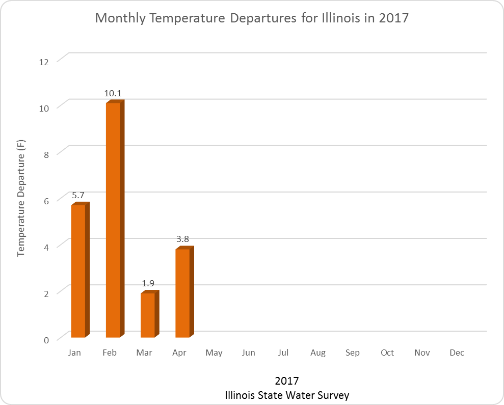
Temperature: The statewide average temperature for April was 56.4 degrees, 3.8 degrees above average and the 11th warmest April on record. The warmest reading for April was 89 degrees at Kaskaskia on April 20.  The coldest reading for the month was 19 degrees at Morrison on April 10.
Statewide records of temperature and precipitation go back to 1895.

Graphs

Here are the temperature departures for 2017. As you can see, every month in 2017 has been well above normal. So far this January-April is the 2nd warmest such period on record with a statewide average temperature of 43.2 degrees, 5.4 degrees above normal. Only 2012 was warmer at 44.5 degrees, 6.7 degrees above normal. [corrected from an earlier version]
image022
Continue reading “Wet April and 2nd Warmest January-April on Record for Illinois”

Widespread, heavy rains possible over next week in Illinois

As of April 25, the statewide average precipitation for Illinois is 2.8 inches, which is 94% of normal. However, we have several opportunities for widespread rains this week and into the weekend, according to the NWS precipitation forecast.
The first round of rain on Wednesday and Thursday has potential rainfall amounts of 1 to 2 inches across most of Illinois, along with the chance for severe weather. Continue reading “Widespread, heavy rains possible over next week in Illinois”

5-Day Rainfall in Illinois and Midwest

Here are the 5-day accumulated rainfall totals for Illinois and the Midwest. Rainfall was heaviest south of Interstate 70 where amounts of 4 to 8 inches were common (lighter shades of blue). The largest 5-day rainfall total was from a CoCoRaHS station at Waltonville (IL-JF-2) with 10.79 inches. CoCoRaHS is a national network of trained volunteer precipitation observers, learn more at cocorahs.org
Continue reading “5-Day Rainfall in Illinois and Midwest”

100-Year Storm Strikes Illinois State Fair

springfield
Radar-estimated rainfall from August 12 storm.

The 5.59 inches of rain reported at the Springfield Airport on Friday night fell in 6 hours. This represents the 100-year storm for that duration in central Illinois, according to Bulletin 70. The results were dramatic, as reported by the Springfield Journal Register.
The concept of the 100 year storm is commonly used by engineers for assessing the risk of heavy rainfall. The 100-year storm is more completely described as the storm expected to have a return period of once every 100 years on average. The phrase “on average” being key. It does not mean the storms are exactly 100 years apart. Instead it means that if you look at rainfall statistics long enough the average frequency of such a storm would be 100 years. Unfortunately, we don’t have hundreds of years of rainfall data. Instead we estimate the values based on fitting a statistical model to the observed data.
While the phrase “100-year storm” is eye catching, it does not do a good job conveying the risk of such an event. A better way of describing it would be the “1% chance storm”, Continue reading “100-Year Storm Strikes Illinois State Fair”